Loading ...
Loading ...
Loading ...
There are details of the selected target appears » page 187,
Clear all own POI categories
›
In the Navigation main menu, tap the function surface →
Manage memory
→
Delete "My POIs"
.
›
Tap the function surface
Delete
and confirm the deletion.
In user profile “ŠKODA Connect Portal” objectives created
The in the user profile on the website ŠKODA Connect Portal or in the applica-
tion ŠKODA Connect drawn objects can be imported to the infotainment
memory.
The requirement for importing the destinations is that Infotainment Online
» page 13 services are activated.
import goals
›
In the Navigation main menu, tap the function surface
→
Destinations
→
→
.
›
or: Tap the
sensor field and then the function surface
→
.
›
Tap on the function surface
Update
.
›
Are new targets available, then confirm the import.
If the user profile on the website ŠKODA Connect Portal or in the application
ŠKODA Connect creates an object and sent to the infotainment, after switch-
ing on the ignition in the infotainment screen displays a message regarding a
new destination with the option to import this displayed.
Guidance to an online destination
›
In the Navigation main menu, tap the function surface
→
Destinations
→
→
.
›
In the list of online dests to visit and select the desired destination.
Delete online dests
›
to delete all Online destinations in the main menu Navigation the function
surface →
Manage memory
→
Delete user data
→
Online destinations
.
›
to delete one Online destination in the main menu Navigation the function
surface
→
Destinations
→ → → →
Edit
→
Delete
.
Image with GPS coordinates
Fig. 218
Image with GPS coordinates
Infotainment enables guidance to the GPScoordinate data stored in the image.
›
Tap the
sensor field and then the function surface
Images
.
›
Select the connected source and open the image with GPS coordinates.
›
Tap the function surface
» Fig. 218 in the image and a menu will open with
the option to start route guidance.
The image can be obtained from an external device in which GPS coordinates
were stored at the time of image creation. This could be created in the
“MyDestination” application and imported » Fig. 216 on page 182.
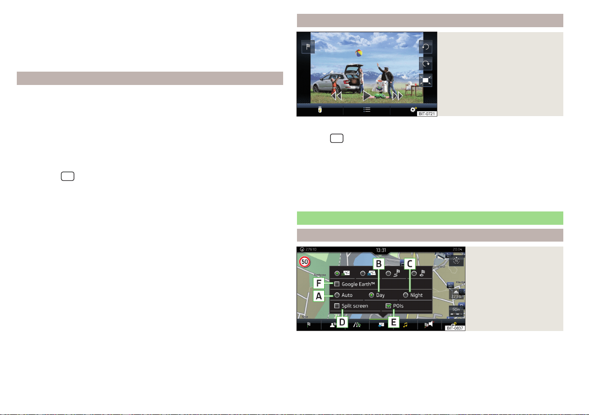
Map
Options for map display
Fig. 219
Map options
›
In the Navigation main menu, tap the function surface
.
The following function surfaces are displayed » Fig. 219.
2D - Two-dimensional map display
3D - Three-dimensional map display
184
Infotainment
Loading ...
Loading ...
Loading ...