Loading ...
Loading ...
Loading ...
Up to this point, this manual covered the assembly and basic operation of your telescope. However, to understand your telescope
more thoroughly, you need to know a little about the night sky. This section deals with observational astronomy in general and
includes information on the night sky and polar alignment.
T
T
h
h
e
e
C
C
e
e
l
l
e
e
s
s
t
t
i
i
a
a
l
l
C
C
o
o
o
o
r
r
d
d
i
i
n
n
a
a
t
t
e
e
S
S
y
y
s
s
t
t
e
e
m
m
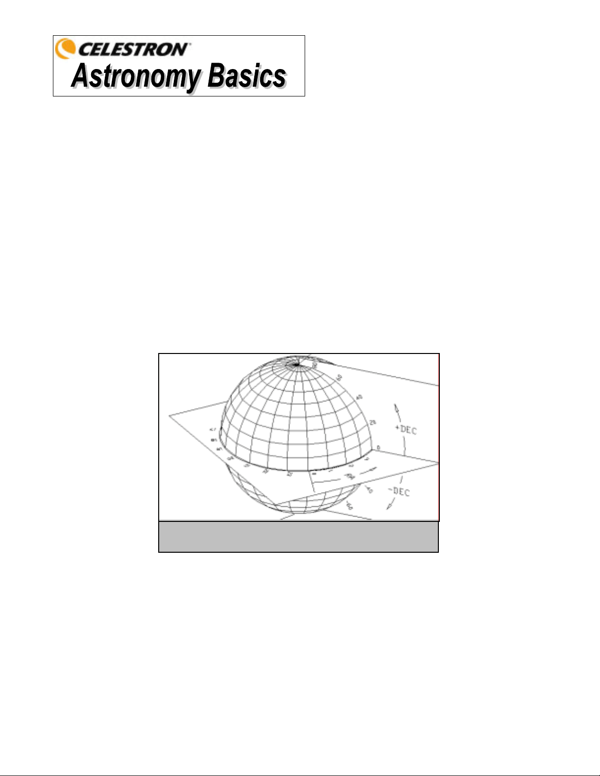
To help find objects in the sky, astronomers use a celestial coordinate system that is similar to our geographical co-ordinate
system here on Earth. The celestial coordinate system has poles, lines of longitude and latitude, and an equator. For the most
part, these remain fixed against the background stars.
The celestial equator runs 360 degrees around the Earth and separates the northern celestial hemisphere from the southern. Like
the Earth's equator, it bears a reading of zero degrees. On Earth this would be latitude. However, in the sky this is referred to as
declination, or DEC for short. Lines of declination are named for their angular distance above and below the celestial equator.
The lines are broken down into degrees, minutes of arc, and seconds of arc. Declination readings south of the equator carry a
minus sign (-) in front of the coordinate and those north of the celestial equator are either blank (i.e., no designation) or preceded
by a plus sign (+).
The celestial equivalent of longitude is called Right Ascension, or R.A. for short. Like the Earth's lines of longitude, they run
from pole to pole and are evenly spaced 15 degrees apart. Although the longitude lines are separated by an angular distance, they
are also a measure of time. Each line of longitude is one hour apart from the next. Since the Earth rotates once every 24 hours,
there are 24 lines total. As a result, the R.A. coordinates are marked off in units of time. It begins with an arbitrary point in the
constellation of Pisces designated as 0 hours, 0 minutes, 0 seconds. All other points are designated by how far (i.e., how long)
they lag behind this coordinate after it passes overhead moving toward the west.
M
M
o
o
t
t
i
i
o
o
n
n
o
o
f
f
t
t
h
h
e
e
S
S
t
t
a
a
r
r
s
s
The daily motion of the Sun across the sky is familiar to even the most casual observer. This daily trek is not the Sun
moving as early astronomers thought, but the result of the Earth's rotation. The Earth's rotation also causes the stars to do
the same, scribing out a large circle as the Earth completes one rotation. The size of the circular path a star follows
depends on where it is in the sky. Stars near the celestial equator form the largest circles rising in the east and setting in
the west. Moving toward the north celestial pole, the point around which the stars in the northern hemisphere appear to
rotate, these circles become smaller. Stars in the mid-celestial latitudes rise in the northeast and set in the northwest. Stars
at high celestial latitudes are always above the horizon, and are said to be circumpolar because they never rise and never
set. You will never see the stars complete one circle because the sunlight during the day washes out the starlight.
However, part of this circular motion of stars in this region of the sky can be seen by setting up a camera on a tripod and
opening the shutter for a couple hours. The timed exposure will reveal semicircles that revolve around the pole. (This
description of stellar motions also applies to the southern hemisphere except all stars south of the celestial equator move
around the south celestial pole.)
Figure 4-1
The celestial sphere seen from the outside showing R.A. and DEC.
Loading ...
Loading ...
Loading ...