Loading ...
Loading ...
Loading ...
76
Apple CarPlay
Attempting to connect to Apple CarPlay.
Communication failed and the system is trying to connect.
Wait for a while. Then, perform the actions below if the error
message is still displayed.
— Restart the iPhone.
— Disconnect the cable from the iPhone, and then connect
the iPhone again after a few seconds.
— Turn the ignition switch to OFF and then to ON.
If the error message is still displayed after performing the
above action, please contact your dealer or an authorized
Pioneer Service Station.
Bluetooth
Error-10
The power failed for the Bluetooth module of this product.
— Turn the ignition switch to OFF and then to ON.
If the error message is still displayed after performing the
above action, please contact your dealer or an authorized
Pioneer Service Station.
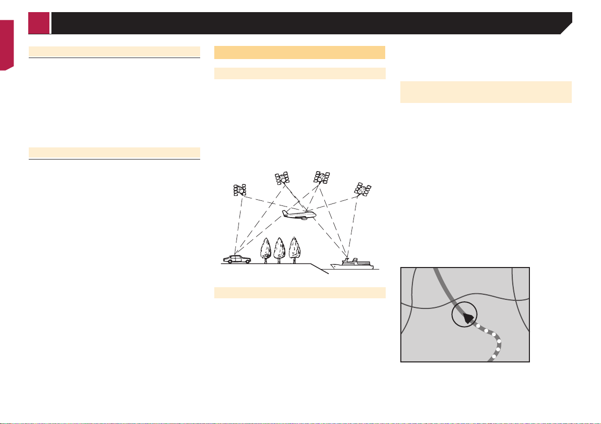
Positioning technology
Positioning by GPS
The Global Positioning System (GPS) uses a network of satellites
orbiting the Earth. Each of the satellites, which orbit at a height
of 68 900 000 feet (21 000 km), continually broadcasts radio
signals giving time and position information. This ensures that
signals from at least three can be picked up from any open area
on the ground’s surface.
The accuracy of the GPS information depends on how good the
reception is. When the signals are strong and reception is good,
GPS can determine latitude, longitude and altitude for accurate
positioning in three dimensions. But if signal quality is poor, only
two dimensions, latitude and longitude, can be obtained and
positioning errors are somewhat greater.
Positioning by dead reckoning
The built-in sensor in the navigation system also calculates your
position. The current location is measured by detecting driving
distance with the speed pulse, the turning direction with the gyro
sensor and inclination of the road with the G sensor.
The built-in sensor can even calculate changes of altitude, and
correct the discrepancies in the distance traveled caused by
driving along winding roads or up slopes.
If you use this navigation system with connecting the speed
pulse, the system will become more accurate than no connec-
tion of speed pulse. So you connect the speed pulse without fail
to get the accuracy of positioning.
p The position of the speed detection circuit vary depending
on the vehicle model. For details, consult your authorized
Pioneer dealer or an installation professional.
p Some types of vehicles may not output a speed signal while
driving at just a few kilometers per hour. In such a case, the
current location of your vehicle may not be displayed cor-
rectly while in traffic congestion or in a parking lot.
How do GPS and dead reckoning
work together?
For maximum accuracy, your navigation system continually com-
pares GPS data with your estimated position as calculated from
the data of built-in sensor. However, if only the data from the
built-in sensor is available for a long period, positioning errors
are gradually compounded until the estimated position becomes
unreliable. For this reason, whenever GPS signals are available,
they are matched with the data of the built-in sensor and used to
correct it for improved accuracy.
p If you use chains on your wheels for winter driving or put on
the spare wheel, errors may suddenly increase because of
difference in wheel diameter. Initialize the sensor status and
it may recover the accuracy to normal condition.
For details, refer to Clearing the status on page 63.
Map matching
As mentioned, the positioning systems used by this navigation
system are susceptible to certain errors. Their calculations may,
on occasion, place you in a location on the map where no road
exists. In this situation, the processing system understands that
vehicles travel only on roads, and can correct your position by
adjusting it to a nearby road. This is called map matching.
With map matching
Without map matching
< CRB5005-B >
Appendix
Loading ...
Loading ...
Loading ...