Loading ...
Loading ...
Loading ...
24
©
2020 DJI All Rights Reserved.
Phantom 4 RTK User Manual
Edit the edge points to adjust the location and shape of the operation area. The instructions are similar to
those for Photogrammetry operations.
If the points imported through the KML/KMZ le are outside of the dotted box, edit them to
make sure they are in the white dotted box so the operation can be performed.
4. After the edge points are added, the app will produce the ight route automatically. The curve of the
altitude of the whole ight route will be displayed at the bottom of the screen. Tap the point on the curve
to show the altitude of this point and the corresponding waypoint on the ight route will turn blue.
5. Congure other settings accordingly.
6. Tap Save, name the operation, and then tap OK.
Linear Flight (Adjustable Height)
Fly the aircraft to the target object and set the position and altitude of the aircraft as a point in the ight area
or import a KML le to add points, and then congure the extension length and other settings. The app
will automatically generate the corresponding linear ight area and ight routes. Once chosen, the mission
will be carried out automatically, following the ight route in the linear ight area. This feature best captures
corridor areas with large changes in elevation, for example, power line corridors, highways, or rivers.
20°
70°
o
B
C
20°
70°
o
ABB
CC
c
a
b
A
B
C
A
B
C
a
b
c
A
B
C
A
B
C
1
2
3
4
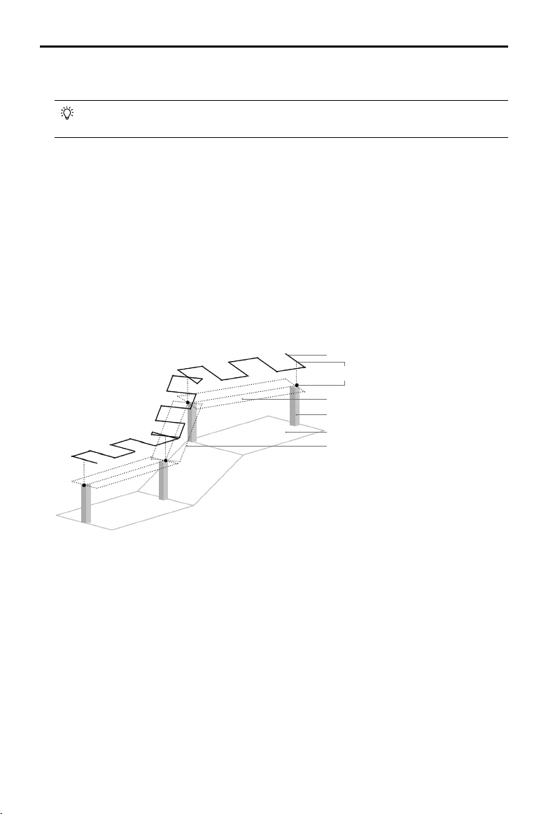
Task Height
Points 1-4 are located at the highest
points of Objects 1-4 respectively
Route
Target Surface
Object 4 (Point 4 being its highest point)
Ground
Extension: to the left and right of the
line connecting recorded points
Planning a Flight Route
Go to the main screen in the DJI GS RTK app, tap Plan, and select Linear Flight (Adjustable Height) to enter
Planning View. Read the instructions in the app carefully before planning.
1. Select the height mode for the added points: Relative Height refers to the relative height above the takeo
point. Absolute Height refers to the actual elevation. The datum of this elevation should be consistent
with the elevation datum used for aircraft positioning, such as the ellipsoidal height in the CGCS2000 or
WGS84 system.
2. Add points in the linear ight area using one of the two methods below:
• Make sure to import the KML/KMZ les according to the instructions mentioned above. Tap the KML
button to the right of Planning View and select the desired le to convert the points in the le into points
in a Linear Flight (Adjustable Height) operation.
• Fly the aircraft to the top of the target object, and then press the C2 button on the remote controller
once.
3. Edit the points: Tap the point to select it and adjust its height. Tap twice to delete a point.
Loading ...
Loading ...
Loading ...