
Loading ...
Loading ...
Loading ...
2
Swipe up or down to scroll through the data screens.
Your most recent reading appears as an oxygen saturation
percentage.
NOTE: If you are too active for the device to determine your
oxygen saturation, dashes appear instead of a percentage.
You should remain stationary for up to 30 seconds while the
device reads your blood oxygen saturation.
Navigating to the Nearest Airport
1
Hold .
2
Select > Nearest.
3
If necessary, go outside to an area with a clear view of the
sky, and wait while the device locates satellites.
A list of the nearest airports appears.
4
Select an airport.
5
Press to start the flight timer.
NOTE: Your activity data is recorded only while the flight
timer is running.
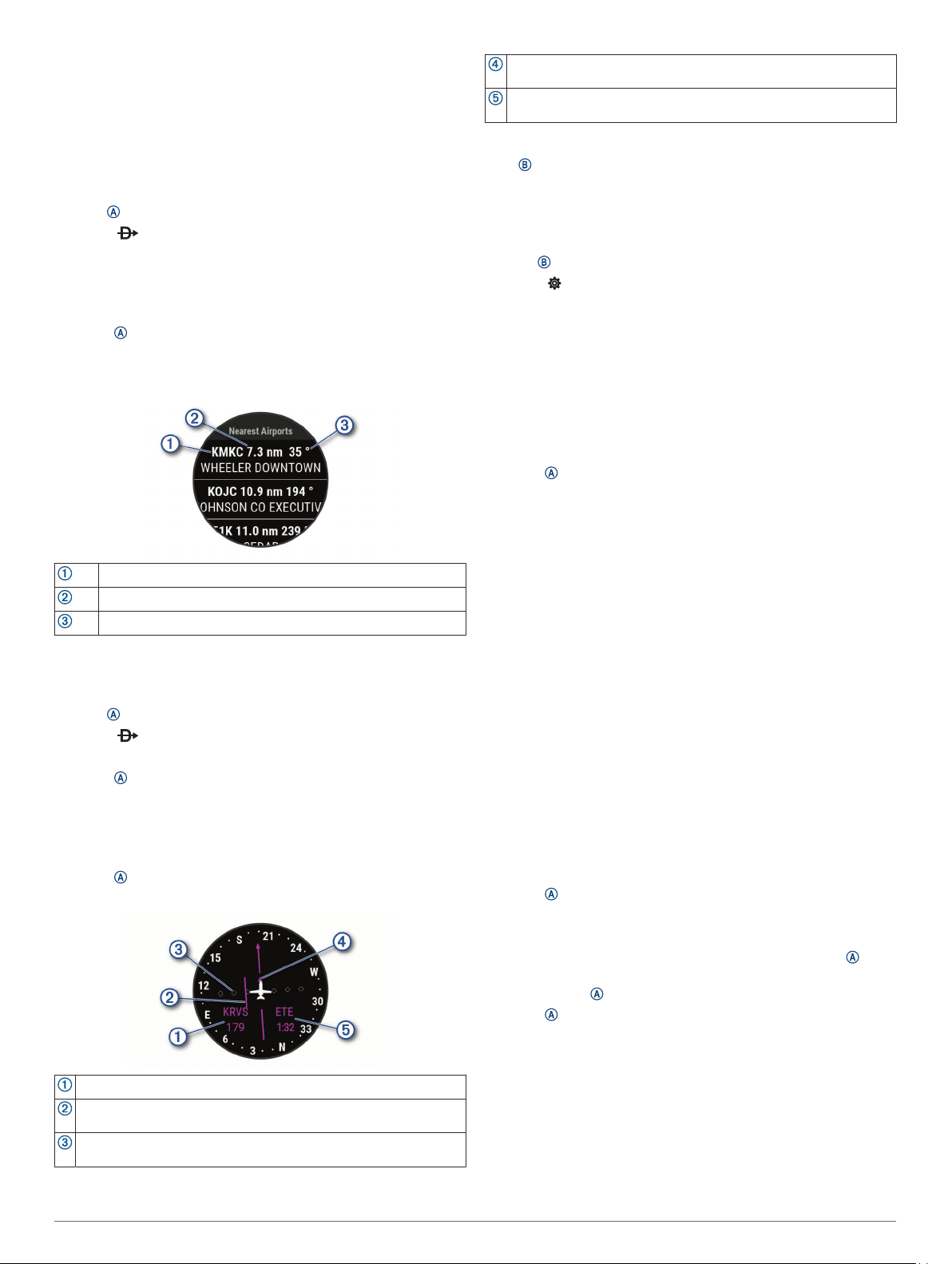
Nearest Airports
Nearest airport identifier
Distance to the nearest airport
Bearing to the nearest airport
Navigating to an Aviation Waypoint by Its Identifier
You can navigate directly to an aviation waypoint by searching
for an alphanumeric identifier.
1
Hold .
2
Select > Enter Ident..
3
Enter all or part of the alphanumeric identifier.
4
Press .
A list of matching waypoints appears.
5
Select the waypoint.
6
Go outside to an area with a clear view of the sky, and wait
while the device locates satellites.
7
Press to begin navigation.
Horizontal Situation Indicator
Distance to the waypoint.
Course deviation indicator (CDI). Indicates the location of the
desired course line in relation to your location.
Course deviation distance. The dots indicate your distance off
course.
To-and-from indicator. Indicates whether you are headed toward or
away from the waypoint.
Estimated time en route (ETE). The time remaining until you reach
your destination.
Stopping Navigation
Hold , and select Stop Navigation.
Disabling the Automatic Flight Timer
You can disable the automatic flight timer so your device does
not automatically record flight data when your ground speed
exceeds 30 kn.
1
Hold .
2
Select > Activities & Apps > FLY.
3
Select the activity settings.
4
Select Flight Timer > Manual.
Flight Plans
A flight plan is a sequence of waypoints or locations that leads
you to your final destination. Flight plans use direct routing
optimized for aviation. You can create flight plans using the
Garmin Pilot
™
app for mobile devices.
Finding a Waypoint
1
Press .
2
Select Navigate > Flight Planning > Find Waypoint.
3
Select an option:
• To find a waypoint by name, select Search by Ident..
• To select from a list of the nearest airports, select Nearest
Airports.
• To select from a list of the nearest navigational aids,
select Nearest Navaids.
• To select from a list of the nearest intersections, select
Nearest Intersection.
4
Select a location.
Sending a Flight Plan to Your Device
You can use the Garmin Pilot app to create flight plans and send
them to your D2 Air device.
1
Connect your device to the Garmin Pilot app (Connecting to
the Garmin Pilot App, page 5).
2
In the Garmin Pilot app, select Home > Flight Plan.
3
Create a flight plan.
4
Select Menu > Connext.
5
Select Send To to send the flight plan to your device.
Following a Flight Plan
1
Press .
2
Select Navigate > Flight Planning > Connext Flight Plan.
3
Select an option:
• To begin navigation for the entire flight plan, press .
• To navigate to a specific waypoint, select the waypoint,
and press .
4
Press to start the flight timer.
Smart Features
Pairing Your Smartphone
To set up the D2 Air device, it must be paired directly through
the Garmin Connect app, instead of from the Bluetooth
®
settings
on your smartphone.
1
From the app store on your smartphone, install and open the
Garmin Connect app.
Smart Features 3
Loading ...
Loading ...
Loading ...