Loading ...
Loading ...
Loading ...

Deleting a Saved Location
NOTE: Deleted locations cannot be recovered.
1 Select Where To? > Saved.
2 Select > Delete Saved Places.
3 Select the box next to the saved locations to delete, and select Delete.
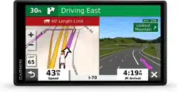
Using the Map
You can use the map to navigate a route (Your Route on the Map, page 13) or to view a map of your
surroundings when no route is active.
1 Select View Map.
2 Touch anywhere on the map.
3 Select an option:
• Drag the map to pan left, right, up, or down.
• To zoom in or out, select or .
• To switch between North Up and 3-D views, select .
• To start a route, select a location on the map, and select Go! (Starting a Route by Using the Map, page 12).
Map Tools
Map tools provide quick access to information and device functions while you view the map. When you activate
a map tool, it appears in a panel at the edge of the map.
Stop: Stops navigation of the active route.
Edit Route: Allows you to take a detour or skip locations in your route (Changing Your Active Route, page 16).
Volume: Allows you to customize the sound and notification settings (Sound and Notification Settings,
page 55).
Cities Ahead: Shows upcoming cities and services along your active route or along a highway (Cities Ahead,
page 27).
Up Ahead: Shows upcoming locations along the route or the road on which you are traveling (Up Ahead,
page 27).
Elevation: Displays elevation changes ahead.
Traffic: Displays traffic conditions along your route or in your area (Viewing Upcoming Traffic, page 30). This
feature is not available in all areas or for all device models.
Trip Data: Displays customizable trip data, such as speed or mileage (Viewing Trip Data from the Map,
page 29).
Turns: Displays a list of upcoming turns in your route (Viewing Turns and Directions, page 14).
Phone: Displays a list of recent phone calls from your connected phone, and displays in-call options while a
phone call is active (Using In-Call Options, page 33).
Weather: Displays weather conditions for your area.
photoLive: Displays live traffic cameras from your photoLive subscription (photoLive Traffic Cameras,
page 35).
Report Camera: Allows you to report a speed or red light camera. This tool is available only when you have
speed or red light camera data on your device and you have an active connection to the Garmin Drive app.
Garmin eLog: Displays hours of service information from the Garmin eLog
™
app. Allows you to change duty
status while you are not driving.
PrePass ®: Shows notifications for upcoming weigh stations and bypass decisions (PrePass
®
, page 39).
26 Using the Map
Loading ...
Loading ...
Loading ...