DĒZL
™
OTR800 / OTR1000 /
LGV800 / LGV1000
Owner’s Manual

© 2020 Garmin Ltd. or its subsidiaries
All rights reserved. Under the copyright laws, this manual may not be copied, in whole or in part, without the written consent of Garmin. Garmin reserves the right to change or
improve its products and to make changes in the content of this manual without obligation to notify any person or organization of such changes or improvements. Go to
www.garmin.com for current updates and supplemental information concerning the use of this product.
Garmin
®
and the Garmin logo are trademarks of Garmin Ltd. or its subsidiaries, registered in the USA and other countries. These trademarks may not be used without the express
permission of Garmin.
BC
™
, dēzl
™
, Garmin eLog
™
, Garmin Express
™
, and myTrends
™
are trademarks of Garmin Ltd. or its subsidiaries. These trademarks may not be used without the express permission
of Garmin.
Android
™
is a trademark of Google LLC. Apple
®
and Mac
®
are trademarks of Apple Inc, registered in the U.S. and other countries. The Bluetooth
®
word mark and logos are owned by
the Bluetooth SIG, Inc., and any use of such word mark or logo by Garmin is under license. Foursquare
®
is a trademark of Foursquare Labs, Inc. in the U.S. and in other countries.
microSD
®
and the microSDHC logo are trademarks of SD-3C, LLC. PrePass
®
is a trademark of the PrePass Safety Alliance. Tripadvisor
®
is a registered trademark of TripAdvisor LLC.
TruckDown
®
is the trademark of TruckDown Info International, Inc. Windows
®
is a registered trademark of Microsoft Corporation in the United States and other countries. Wi‑Fi
®
and
Wi‑Fi CERTIFIED MiraCast
™
are registered marks of Wi-Fi Alliance Corporation.

Table of Contents
Getting Started.................................1
Device Overview...................................... 2
Mounting and Powering the Device in
Your Vehicle............................................ 3
Installing the Screw-Down Mount on
the Dashboard..................................... 5
Installing the Ball Mount Adapter...... 6
Turning the Device On or Off.................. 6
Acquiring GPS Signals............................ 7
Home Screen...........................................7
Opening an App................................... 8
Adding Shortcuts to the Home
Screen.................................................. 8
Viewing Notifications......................... 8
Status Bar Icons.................................. 8
Using the Touchscreen...........................8
Adjusting the Screen Brightness........... 9
Vehicle Profiles................................9
Adding a Vehicle Profile......................... 9
Car Profile................................................9
Switching the Vehicle Profile................. 9
Changing Your Trailer Information...... 10
Editing a Vehicle Profile....................... 10
Driver Awareness Features and
Alerts............................................. 11
Enabling or Disabling Driver Alerts...... 11
Red Light and Speed Cameras............ 12
Navigating to Your Destination....... 12
Routes................................................... 12
Starting a Route.................................... 12
Starting a Route by Using the Map.. 12
Going Home...................................... 13
Your Route on the Map.........................13
Active Lane Guidance....................... 14
Viewing Popular Truck Paths on the
Map.................................................... 14
Viewing Turns and Directions.......... 14
Viewing the Entire Route on the
Map.................................................... 14
Arriving at Your Destination................. 14
Completing a Truck Route................15
Parking Near Your Destination.........15
Changing Your Active Route................ 16
Adding a Location to Your Route..... 16
Shaping Your Route.......................... 16
Taking a Detour................................. 16
Changing the Route Calculation
Mode.................................................. 16
Stopping the Route............................... 16
Using Suggested Routes...................... 17
Avoiding Delays, Tolls, and Areas........17
Avoiding Traffic Delays on Your
Route..................................................17
Avoiding Toll Roads.......................... 17
Avoiding Toll Stickers....................... 17
Avoiding Road Features................... 17
Avoiding Environmental Zones........ 18
Custom Avoidances......................... 18
Finding and Saving Locations......... 19
Points of Interest.................................. 19
Finding Trucking Points of Interest..... 19
Finding a Location Using the Search
Bar......................................................... 20
Finding an Address............................... 20
Finding a Location by Category........... 20
Searching Within a Category............ 20
Location Search Results...................... 21
Changing the Search Area................... 21
Custom Points of Interest.................... 22
Installing POI Loader........................ 22
Finding Custom POIs........................ 22
Parking.................................................. 22
Finding Truck Parking....................... 22
Finding Truck Parking in Europe...... 22
Finding Parking Near Your Current
Location............................................. 22
Understanding Parking Colors and
Symbols............................................. 22
Search Tools......................................... 22
Finding an Intersection..................... 23
Finding a Location Using
Coordinates....................................... 23
Foursquare............................................ 23
Connecting to Your Foursquare
Account............................................. 23
Searching Foursquare Points of
Interest.............................................. 23
Viewing Foursquare Location
Details................................................ 23
Table of Contents i

Tripadvisor............................................ 23
Finding Tripadvisor Points of
Interest.............................................. 24
Viewing Recently Found Locations..... 24
Clearing the List of Recently Found
Locations........................................... 24
Viewing Current Location
Information........................................... 24
Finding Emergency Services and
Fuel.................................................... 24
Getting Directions to Your Current
Location............................................. 24
Adding a Shortcut................................. 24
Removing a Shortcut........................ 25
Saving Locations.................................. 25
Saving a Location............................. 25
Saving Your Current Location.......... 25
Editing a Saved Location.................. 25
Assigning Categories to a Saved
Location............................................. 25
Deleting a Saved Location................26
Using the Map................................ 26
Map Tools............................................. 26
Viewing a Map Tool.......................... 27
Up Ahead............................................... 27
Viewing Upcoming Locations.......... 27
Customizing the Up Ahead
Categories......................................... 27
Cities Ahead.......................................... 27
Viewing Upcoming Cities and Exit
Services............................................. 27
Warning and Alert Symbols..................28
Restriction Warnings........................ 28
Road Condition Warnings.................29
Alerts................................................. 29
Trip Information.................................... 29
Viewing Trip Data from the Map...... 29
Viewing the Trip Log......................... 29
Resetting Trip Information............... 29
Viewing Upcoming Traffic....................30
Viewing Traffic on the Map.............. 30
Searching for Traffic Incidents........ 30
Customizing the Map........................... 30
Customizing the Map Layers........... 30
Changing the Map Data Field........... 30
Changing the Map Perspective........ 30
Live Services, Traffic, and
Smartphone Features..................... 31
Pairing with Your Smartphone............. 31
Tips After Pairing the Devices..........31
Pairing Additional Bluetooth
Devices.............................................. 31
Going to an Address or Location Using
the Garmin Drive App........................... 32
Smart Notifications.............................. 32
Receiving Notifications.................... 32
Hands-Free Calling............................... 32
Placing a Call.....................................33
Receiving a Call................................. 33
Using In-Call Options........................ 33
Saving a Phone Number as a
Preset................................................ 33
Wireless Headsets................................ 33
Enabling or Disabling Bluetooth
Features................................................ 33
Showing or Hiding App Notifications
(Android™)......................................... 33
Showing or Hiding Notification
Categories for Your Apple®
Device................................................ 34
Disconnecting a Bluetooth Device.......34
Deleting a Paired Bluetooth Device..... 34
Deleting a Paired Phone....................... 34
Traffic............................................ 34
Receiving Traffic Data Using Your
Smartphone...........................................34
Viewing Traffic on the Map.................. 34
Searching for Traffic Incidents........ 35
photoLive Traffic Cameras.................. 35
Viewing and Saving photoLive Traffic
Cameras............................................ 35
Saving a Traffic Camera................... 35
Vehicle and Driver Tools................ 35
Break Planning...................................... 35
Taking a Suggested Break............... 35
Starting the Break Timer.................. 36
Pausing and Resetting the Break
Timer..................................................36
Adjusting Drive Hours....................... 36
Adjusting the Daily Driving Limit...... 36
IFTA....................................................... 36
ii Table of Contents

Entering Fuel Data.............................36
Editing Fuel Data............................... 37
Viewing and Exporting a Jurisdiction
Summary........................................... 37
Editing and Exporting Trip Reports.. 37
Viewing Exported Jurisdiction
Summaries and Trip Reports........... 37
Logging Service History....................... 38
Adding Service Categories............... 38
Deleting Service Categories............. 38
Renaming Service Categories.......... 38
Deleting Service Records................. 38
Editing a Service Record...................38
PrePass®.............................................. 39
Garmin eLog.................................. 39
Setting Up Your Garmin eLog
Adapter.................................................. 39
Transferring Garmin eLog Data from
Another Device......................................39
Backing Up Data................................40
Restoring Data.................................. 40
Daily Operation Guidelines................... 40
Starting a Drive..................................... 40
Garmin eLog App Overview.............. 41
Garmin eLog Map Tool Overview.....42
Driving in a Team.............................. 42
Changing Duty Status....................... 43
Viewing Hours of Service................. 43
Recording Adverse Conditions........ 43
Reviewing Logs................................. 44
Certifying Daily Logs......................... 44
Submitting a Daily Log......................44
Exporting and Saving a Record of Duty
Status (RODS) Report....................... 44
Recording Trailers and Shipments.. 44
Roadside Inspection............................. 44
Viewing Inspection Information....... 44
Transferring Data to an Inspector
Using a USB Device...........................45
Transferring Data to an Inspector
Using Bluetooth Wireless
Technology........................................ 45
Diagnostics and Malfunctions............. 45
Viewing Diagnostics and
Malfunctions..................................... 46
Diagnostic Definitions...................... 47
Malfunction Definitions.................... 48
Administrator Functions...................... 49
Adding Driver Profiles....................... 49
Editing a Driver Profile...................... 49
Clearing Garmin eLog App Data...... 49
Voice Command.............................50
Tips for Speaking to the Device........... 50
Launching Garmin Voice-Activated
Navigation............................................. 50
Checking Your Arrival Time..................50
Placing a Phone Call Using Your
Voice...................................................... 50
Changing Device Settings Using Your
Voice...................................................... 50
Using the Apps............................... 50
Viewing the Owner's Manual on
Your Device........................................... 50
Viewing the Truck Map.........................51
Trip Planner........................................... 51
Planning a Trip.................................. 51
Editing and Reordering Locations in a
Trip..................................................... 51
Discovering Attractions Along Your
Trip..................................................... 51
Changing Routing Options for a
Trip..................................................... 52
Navigating to a Saved Trip............... 52
Editing and Saving Your Active
Route..................................................52
Viewing Previous Routes and
Destinations.......................................... 52
Viewing the Weather Forecast............. 52
Viewing Weather Near a Different
City..................................................... 53
Media Player......................................... 53
Adding the Music Player Tool to the
Map.................................................... 53
Settings......................................... 54
Navigation Settings.............................. 54
Map and Vehicle Settings.................... 54
Enabling Maps.................................. 54
Connecting to a Wireless Network...... 54
Enabling Bluetooth Wireless
Technology............................................54
Driver Assistance Settings................... 55
Traffic Settings..................................... 55
Table of Contents iii

Display Settings.................................... 55
Sound and Notification Settings.......... 55
Adjusting Sound and Notification
Volume.............................................. 56
Enabling or Disabling Location
Services................................................. 56
Setting the Text Language................... 56
Date and Time Settings........................ 56
Device Settings..................................... 56
Restoring Settings................................ 56
Device Information......................... 56
Viewing E-label Regulatory and
Compliance Information...................... 56
Specifications....................................... 57
Charging the Device............................. 57
Device Maintenance....................... 57
Garmin Support Center.........................57
Updating Maps and Software Using a
Wi‑Fi Network........................................ 58
Updating Maps and Software with
Garmin Express.....................................59
Installing Garmin Express................ 60
Device Care........................................... 60
Cleaning the Outer Casing................60
Cleaning the Touchscreen............... 60
Avoiding Theft................................... 60
Resetting the Device............................. 60
Removing the Device, Mount, and
Suction Cup........................................... 60
Removing the Mount from the Suction
Cup..................................................... 60
Removing the Suction Cup from the
Windshield......................................... 61
Troubleshooting.............................61
The suction cup will not stay on my
windshield............................................. 61
The mount does not hold my device in
place while I drive................................. 61
My device is not acquiring satellite
signals................................................... 61
The device does not charge in my
vehicle................................................... 61
My battery does not stay charged for
very long................................................ 61
My device does not connect to my
phone..................................................... 62
Appendix........................................62
Backup Cameras.................................. 62
Pairing a BC™ 35 Backup Camera with
a Garmin Navigation Device............. 62
Viewing the Backup Camera............ 62
Connecting a Dash Camera to the
Powered Mount.................................... 63
Data Management................................ 63
About Memory Cards........................63
Installing a Memory Card for Maps
and Data............................................ 64
Formatting the Memory Card........... 64
Connecting the Device to Your
Computer........................................... 64
Transferring Data From Your
Computer........................................... 64
Purchasing Additional Maps................ 64
Purchasing Accessories...................... 64
Index..............................................65
iv Table of Contents

Getting Started
WARNING
See the Important Safety and Product Information guide in the product box for product warnings and other
important information.
• Update the maps and software on your device (Updating Maps and Software Using a Wi‑Fi Network,
page 58).
• Mount the device in your vehicle and connect it to power (Mounting and Powering the Device in Your Vehicle,
page 3).
• Adjust the volume (Adjusting Sound and Notification Volume, page 56) and display brightness (Adjusting the
Screen Brightness, page 9).
• Set up a vehicle profile for your truck (Adding a Vehicle Profile, page 9).
• Navigate to your destination (Starting a Route, page 12).
Getting Started 1

Device Overview
Microphone for hands-free calling and voice command
Volume control
Power key
Micro USB power and data port
Map and data memory card slot
Magnetic mount interface with 14-pin connector
Speaker
2 Getting Started
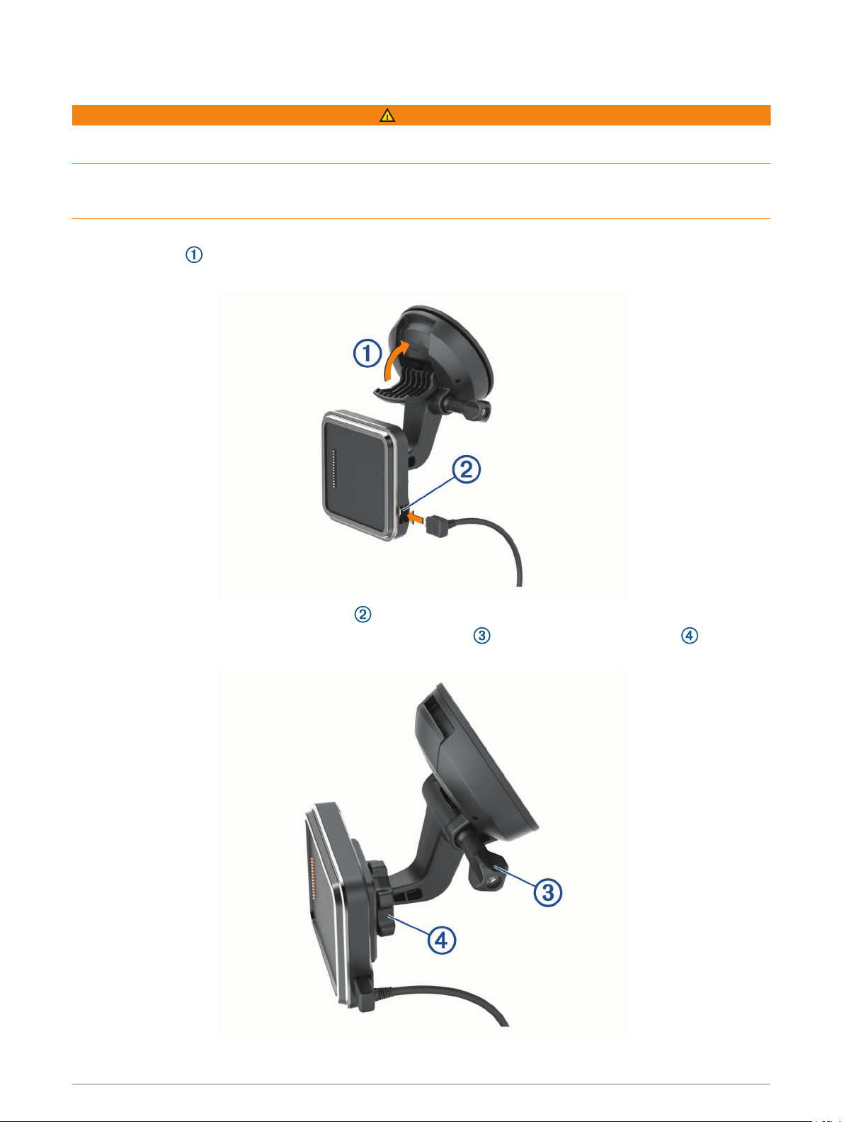
Mounting and Powering the Device in Your Vehicle
WARNING
This product contains a lithium-ion battery. To prevent the possibility of personal injury or product damage
caused by battery exposure to extreme heat, store the device out of direct sunlight.
Both the device and its mount contain magnets. Under certain circumstances, magnets may cause interference
with some internal medical devices and electronic devices, including pacemakers, insulin pumps, or hard drives
in laptop computers. Keep the device away from medical devices and electronic devices.
Before you use your device on battery power, you should charge it.
1 Open the lever , press the suction cup to the windshield, and flip the lever back toward the windshield.
The lever must be oriented toward the top of the windshield.
2 Plug the vehicle power cable into the port on the mount.
3 If necessary, loosen the thumbscrew on the suction cup arm and the nut on the ball mount , and adjust
the mount for better viewing and operation.
Getting Started 3
4 Tighten the thumbscrew on the suction cup arm and the nut on the ball mount.
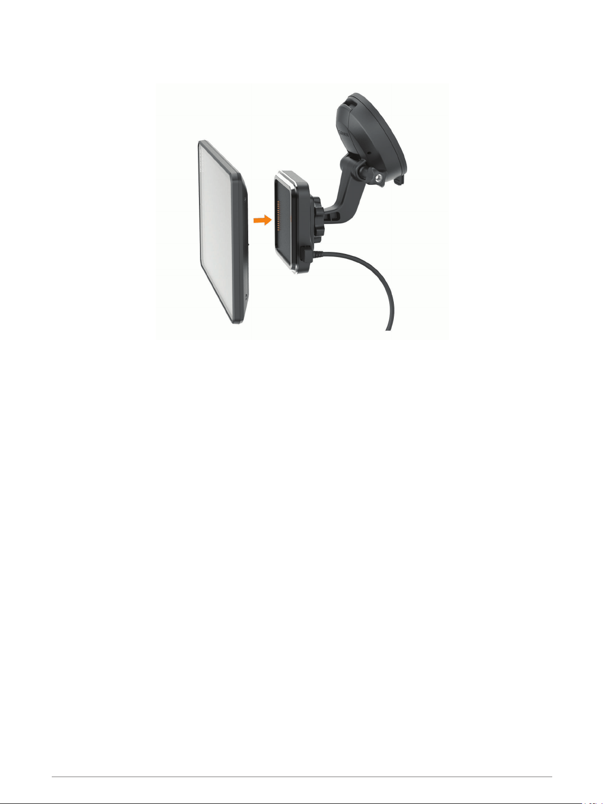
5 Place the device onto the magnetic mount.
6 Plug the other end of the vehicle power cable into a power outlet in your vehicle.
4 Getting Started
Installing the Screw-Down Mount on the Dashboard
Before you can attach the screw-down ball mount to your dashboard, you must select a suitable location on the
dashboard.
WARNING
It is your responsibility to ensure the mounting location complies with all applicable laws and ordinances, and
does not block your view of the road during the safe operation of your vehicle.
NOTICE
Avoid wires, gauges, air bags, air bag covers, HVAC, and other items when drilling pilot holes and attaching the
mount to the vehicle. Garmin
®
is not responsible for any damages or consequences arising from the
installation.
NOTICE
Garmin recommends professional installation of the screw-down ball mount.
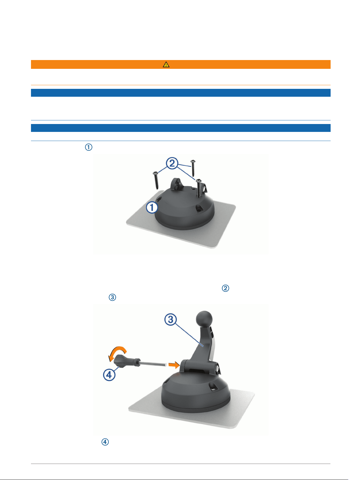
1 Place the mount on the selected location.
2 Using the mount as a template, mark the three screw locations.
3 Drill pilot holes (optional).
For some types of mounting material, drilling pilot holes is necessary.
4 Securely fasten the mount to the surface using the supplied screws .
5 Insert the ball mount arm into the mount.
6 Insert the thumbscrew into the mount, and tighten it to secure the ball mount arm.
Getting Started 5

Installing the Ball Mount Adapter
Your device includes a one-inch ball mount that is compatible with third-party mounting solutions.
1 Remove the four screws securing the mount socket to the magnetic mount.
2 Remove the mount socket.
3 Secure the one-inch ball mount to the magnetic mount using the screws removed in step 1.
Turning the Device On or Off
• To turn the device on, press the power key , or connect the device to power.
• To put the device in power saving mode, press the power key while the device is on.
While in power saving mode, the screen is off and the device uses very little power, but it can wake instantly
for use.
TIP: You can charge your device faster by putting it in power saving mode while charging the battery.
• To turn off the device completely, hold the power key until a prompt appears on the screen, and select Power
Off.
6 Getting Started
Acquiring GPS Signals
When you turn on your navigation device, the GPS receiver must collect satellite data and establish the current
location. The time required to acquire satellite signals varies based on several factors, including how far you
are from the location where you last used your navigation device, whether you have a clear view of the sky, and
how long it has been since you last used your navigation device. The first time you turn on your navigation
device, it may take several minutes to acquire satellite signals.
1 Turn on the device.
2 Verify appears in the status bar, and enable location services if it does not (Enabling or Disabling Location
Services, page 56).
3 If necessary, go to an open area with a clear view of the sky, away from tall buildings and trees.
Acquiring Satellites appears at the top of the navigation map until the device determines your location.
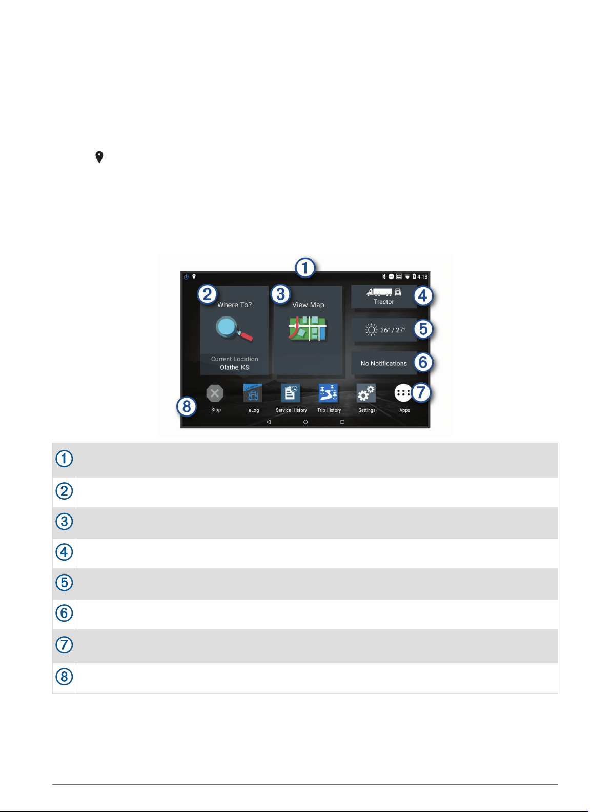
Home Screen
NOTE: The home screen layout may vary if it has been customized.
Swipe down to view notifications.
Swipe down twice to quickly change settings and backlight brightness.
Select to start a route.
Select to view the map.
Select to change your vehicle profile.
Select to view weather information for your current location. The Garmin Drive
™
app is required.
Select to view smart notifications. The Garmin Drive app is required.
Select to open the app drawer. The app drawer contains shortcuts to all the apps installed on your
device.
Hold to customize the wallpaper or add widgets to the home screen.
Getting Started 7
Opening an App
The home screen contains shortcuts for frequently used apps. The app drawer contains all the apps installed
on your device, organized into two tabs. The dēzl tab contains Garmin apps useful for navigation, dispatching,
and hours of service recording. The Tools tab contains apps useful for communication and other tasks.
Select an option to open an app:
• Select an app shortcut from the home screen.
• Select , select a tab, and select an app.
Adding Shortcuts to the Home Screen
1 Select .
2 Select an app tab to view additional applications.
3 Hold an application, and drag it to a location on the home screen.
Viewing Notifications
1 Swipe down from the top of the screen.
The list of notifications appears.
2 Select an option:
• To launch the action or app mentioned in the notification, select the notification.
• To dismiss a notification, swipe the notification to the right.
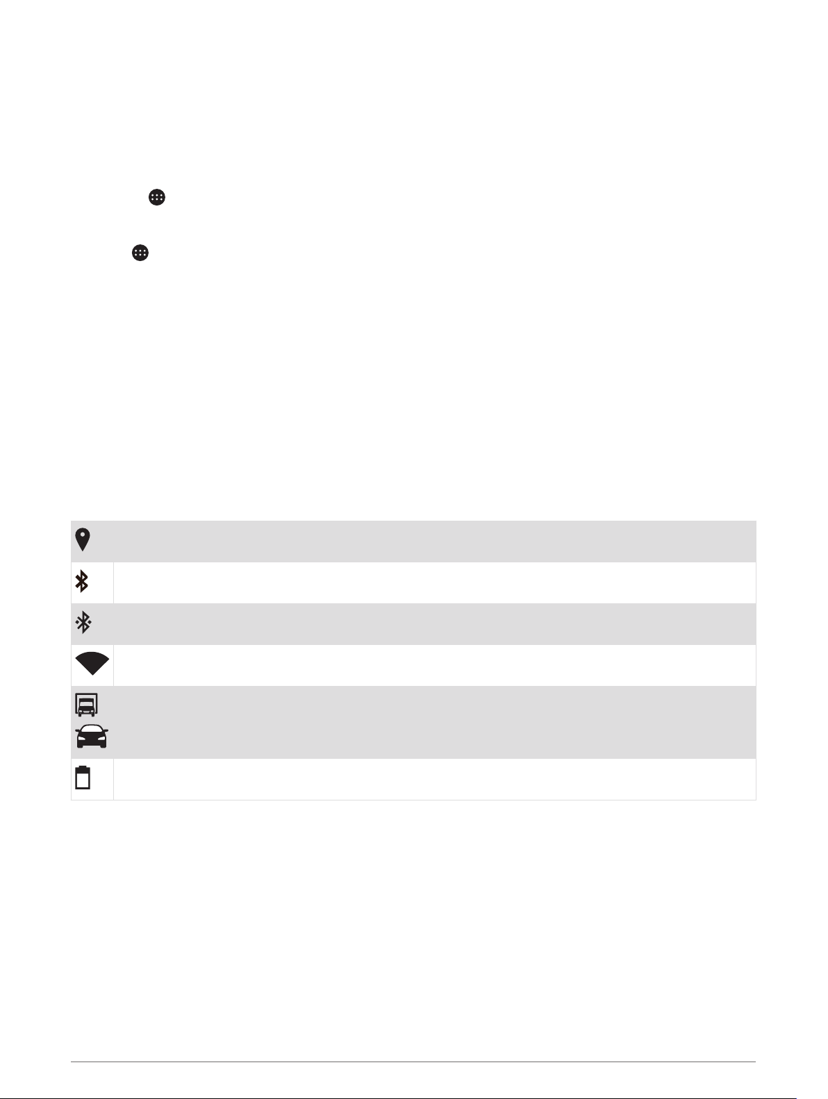
Status Bar Icons
The status bar is located at the top of the main menu. The status bar icons display information about features
on the device.
Location services is enabled (Enabling or Disabling Location Services, page 56).
Bluetooth
®
technology is enabled.
Connected to a Bluetooth device.
Connected to a Wi‑Fi
®
network (Connecting to a Wireless Network, page 54).
Active vehicle profile. Swipe down twice and select to view the vehicle profile settings (Vehicle Profiles,
page 9).
Battery charge level.
Using the Touchscreen
• Tap the screen to select an item.
• Drag or swipe your finger across the screen to pan or scroll.
• Pinch two fingers together to zoom out.
• Spread two fingers apart to zoom in.
8 Getting Started

Adjusting the Screen Brightness
The device can use an ambient light sensor to adjust the screen brightness to your vehicle conditions
automatically (Display Settings, page 55). You can also adjust the brightness manually, using either the
notification panel or the settings menu.
1 Select an option:
• Swipe down twice from the top of the screen to expand the quick settings in the notification panel.
• Select Settings > Device > Display > Brightness Level.
2 Use the slider bar to adjust the brightness.
Vehicle Profiles
WARNING
Entering your vehicle profile characteristics does not guarantee that your vehicle's characteristics will be
accounted for in all route suggestions or that you will receive the warning icons in all cases. Limitations may
exist in the map data such that your device cannot account for these restrictions or road conditions in all
cases. Always defer to all posted road signs and road conditions when making driving decisions.
Routing and navigation are calculated differently based on your vehicle profile. The activated vehicle profile is
indicated by an icon in the status bar. The navigation and map settings on your device can be customized
separately for each vehicle type.
When you activate a truck vehicle profile, the device avoids including restricted or impassable areas in routes
based on the dimensions, weight, and other characteristics you entered for your vehicle.
Adding a Vehicle Profile
You can add a vehicle profile that includes the weight, dimensions, and other characteristics for your vehicle.
1 From the home screen, select the vehicle profile widget (Home Screen, page 7).
2 Select an option:
• To add a straight truck with a permanently attached cargo area, select Straight Truck.
• To add a tractor or a tractor-trailer combination, select Tractor.
• To add a bus, select Bus.
3 Follow the on-screen instructions to enter the vehicle characteristics.
After you add a vehicle profile, you can edit the profile to enter additional detailed information, such as the
vehicle identification number or trailer number (Editing a Vehicle Profile, page 10).
Car Profile
The car profile is a preloaded vehicle profile intended for use in an automobile without a trailer. While using the
car profile, the device calculates standard automobile routes, and routing for large vehicles is not available.
Some features and settings specific to large vehicles are not available while using the car profile.
Switching the Vehicle Profile
Each time you turn on your device, it prompts you to select a vehicle profile. You can manually switch to
another vehicle profile at any time.
1 Select an option:
• Swipe down twice from the top of the screen, and select the vehicle profile icon, such as or .
• From the home screen, select the vehicle profile widget (Home Screen, page 7).
2 Select a vehicle profile.
The vehicle profile information appears, including measurements and weight.
3 Select Select.
Vehicle Profiles 9

Changing Your Trailer Information
Before you can change your trailer information, you must enter a vehicle profile for a tractor (Adding a Vehicle
Profile, page 9).
When you change the trailer on your tractor, you can change the trailer information in your vehicle profile
without changing the tractor information. You can switch quickly between frequently used trailers.
1 From the home screen, select the vehicle profile widget (Home Screen, page 7).
2 Select the tractor vehicle profile to use with the trailer.
3 Select .
4 Select an option:
• To use a recent trailer configuration, select a trailer configuration from the list.
• To enter a new trailer configuration, select New Configuration, and enter the trailer information.
Editing a Vehicle Profile
You can edit a vehicle profile to change vehicle information or to add detailed information to a new vehicle
profile, such as the vehicle identification number, trailer number, or odometer reading. You can also rename or
delete a vehicle profile.
1 From the home screen, select the vehicle profile widget (Home Screen, page 7).
2 Select the vehicle profile to edit.
3 Select an option:
• To edit the vehicle profile information, select , and select a field to edit.
• To rename a vehicle profile, select > > Rename Profile.
• To delete the vehicle profile, select > > Delete.
10 Vehicle Profiles

Driver Awareness Features and Alerts
CAUTION
The driver alerts and speed limit features are for information only and do not replace your responsibility to
abide by all posted speed limit signs and to use safe driving judgment at all times. Garmin is not responsible
for any traffic fines or citations you receive for failing to follow all applicable traffic laws and signs.
Your device provides features that can help encourage safer driving and increase efficiency, even when you are
driving in a familiar area. The device plays an audible tone or message and displays information for each alert.
You can enable or disable the audible tone for some types of driver alerts. Not all alerts are available in all
areas.
Schools: The device plays a tone and displays the distance to and speed limit (if available) for an upcoming
school or school zone.
Speed limit reduction: The device plays a tone and displays the upcoming reduced speed limit so you can be
prepared to reduce your speed.
Speed limit exceeded: The device plays a tone and displays a red border on the speed limit icon when you
exceed the posted speed limit for the current road.
Speed limit change: The device plays a tone and displays the upcoming speed limit so you can be prepared to
adjust your speed.
Railroad crossing: The device plays a tone and displays the distance to an upcoming railroad crossing.
Animal crossing: The device plays a tone and displays the distance to an upcoming animal crossing area.
Curves: The device plays a tone and displays the distance to a curve in the road.
Slower traffic: The device plays a tone and displays the distance to slower traffic when you approach slower
traffic at a higher speed. Your device must be receiving traffic information to use this feature (Traffic,
page 34).
No trucks allowed: The device plays a tone when you approach a road where no trucks are allowed.
Risk of grounding: The device plays a tone and displays a message when you approach a road where your
vehicle could become grounded.
Lateral wind: The device plays a tone and displays a message when you approach a road where there is risk of
lateral wind.
Narrow road: The device plays a tone and displays a message when you approach a road that may be too
narrow for your vehicle.
Steep hill: The device plays a tone and displays a message when you approach a steep hill.
State and country borders: The device plays a tone and displays a message when you approach the border of a
state or country.
Enabling or Disabling Driver Alerts
You can enable or disable several types of driver alerts.
1 Select Settings > Driver Assistance > Audible Driver Alerts.
2 Select or clear the check box next to each alert.
Driver Awareness Features and Alerts 11

Red Light and Speed Cameras
NOTICE
Garmin is not responsible for the accuracy of or the consequences of using a red light or speed camera
database.
NOTE: This feature is not available for all regions or product models.
Information about red light and speed camera locations is available in some areas for some product models.
The device alerts you when you approach a reported speed or red light camera.
• In some areas, your device can receive live red light and speed camera data while connected to a
smartphone running the Garmin Drive app.
• You can use the Garmin Express
™
software (garmin.com/express) to update the camera database stored on
your device. You should update your device frequently to receive the most up-to-date camera information.
Navigating to Your Destination
Routes
A route is a path from your current location to one or more destinations.
• The device calculates a recommended route to your destination based on the preferences you set, including
the route calculation mode (Changing the Route Calculation Mode, page 16) and avoidances (Avoiding
Delays, Tolls, and Areas, page 17).
• The device can automatically avoid roads that are not appropriate for the active vehicle profile.
• You can start navigating to your destination quickly using the recommended route, or you can select an
alternate route (Starting a Route, page 12).
• If there are specific roads you need to use or avoid, you can customize the route (Shaping Your Route,
page 16).
• You can add multiple destinations to a route (Adding a Location to Your Route, page 16).
Starting a Route
1 Select Where To?, and search for a location (Finding and Saving Locations, page 19).
2 Select a location.
3 Select an option:
• To start navigating using the recommended route, select Go!.
• To choose an alternate route, select , and select a route.
Alternate routes appear to the right of the map.
• To edit the course of the route, select > Edit Route, and add shaping points to the route (Shaping Your
Route, page 16).
The device calculates a route to the location and guides you using voice prompts and information on the map
(Your Route on the Map, page 13). A preview of the major roads in your route appears at the edge of the map
for several seconds.
If you need to stop at additional destinations, you can add the locations to your route (Adding a Location to Your
Route, page 16).
Starting a Route by Using the Map
You can start route by selecting a location from the map.
1 Select View Map.
2 Drag and zoom the map to display the area to search.
3 Select a point, such as a street, intersection, or address location.
4 Select Go!.
12 Navigating to Your Destination

Going Home
The first time you start a route home, the device prompts you to enter your home location.
1 Select Where To? > Go Home.
2 If necessary, enter your home location.
Editing Your Home Location
1 Select Where To? > > Set Home Location.
2 Enter your home location.
Your Route on the Map
As you travel, the device guides you to your destination using voice prompts and information on the map.
Instructions for your next turn or exit, or other actions appear across the top of the map.
Distance to the next action.
Next action in the route. Indicates the next turn, exit, or other action and the lane in which you should
travel, if available.
Name of the street or exit associated with the next action.
Route highlighted on the map.
Next action in the route. Arrows on the map indicate the location of upcoming actions.
Select to toggle popular truck routes on the map.
Map tool shortcuts.
Map tools. You can select the tools to show you more information about your route and surroundings.
Data fields.
TIP: You can touch these fields to change the information they show (Changing the Map Data Field,
page 30).
Vehicle speed.
Navigating to Your Destination 13
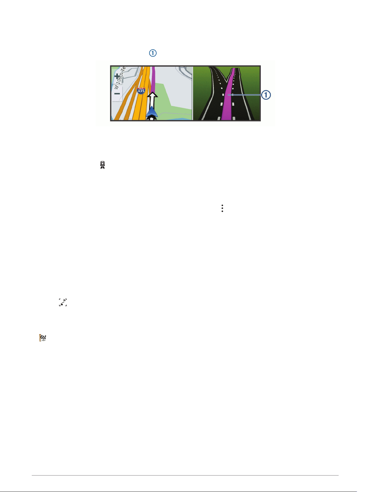
Active Lane Guidance
As you approach some turns, exits, or interchanges in your route, a detailed simulation of the road appears
beside the map, if available. A colored line indicates the proper lane for the turn.
Viewing Popular Truck Paths on the Map
You can enable the device to highlight popular truck paths on the map. This can be useful to help you choose
roads that are more accessible for your vehicle.
From the map, select .
Viewing Turns and Directions
While navigating a route, you can view upcoming turns, lane changes, or other directions for your route.
1 From the map, select an option:
• To view upcoming turns and directions as you navigate, select > Turns.
The map tool displays the next several turns or directions beside the map. The list updates automatically
as you navigate the route.
• To view the complete list of turns and directions for the entire route, select the text bar at the top of the
map.
2 Select a turn or direction (optional).
Detailed information appears. An image of the junction may appear for junctions on major roadways, if
available.
Viewing the Entire Route on the Map
1 While navigating a route, select anywhere on the map.
2 Select .
Arriving at Your Destination
When you approach your destination, the device provides information to help you complete your route.
• indicates the location of your destination on the map, and a voice prompt announces you are approaching
your destination.
• When you approach some destinations, the device automatically suggests parking areas. You can select
More to view a full list of suggested parking areas (Parking Near Your Destination, page 15).
• When you approach some destinations while using a truck vehicle profile, the device automatically prompts
you to find a truck destination such as a loading dock or truck parking. You can select a suggested point on
the map, and then select Go! to navigate to that destination.
• When you stop at your destination, the device automatically ends the route. If the device does not detect
your arrival automatically, you can select Stop to end your route.
14 Navigating to Your Destination
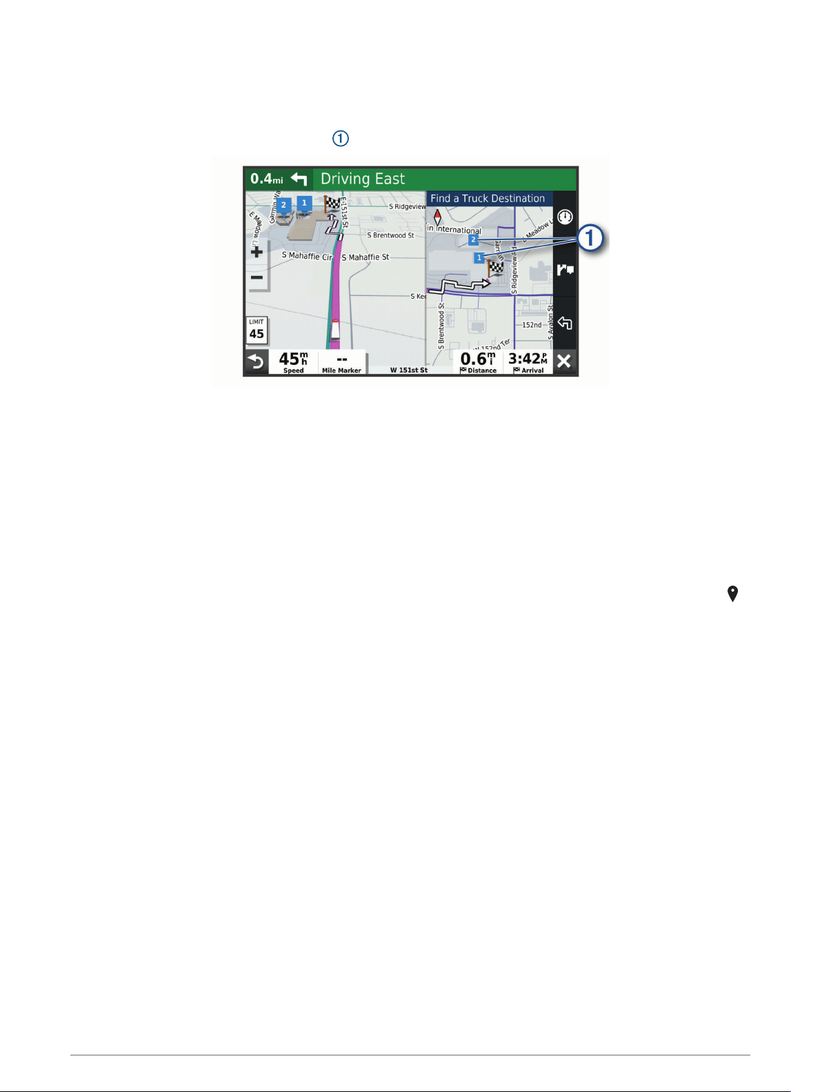
Completing a Truck Route
When you approach some truck destinations, a map tool appears to help you find common truck destinations
such as parking areas and loading docks.
1 Select a numbered trucking destination .
2 Select Go!.
Parking Near Your Destination
Your device can help you find a parking spot near your destination. When you approach some destinations, the
device automatically suggests parking areas.
NOTE: This feature should be used only when you are using the car vehicle profile. While using a truck vehicle
profile, you can search for truck parking near your destination (Finding Truck Parking, page 22).
1 Select an option:
• When the device suggests parking, select More to see all suggested parking areas.
NOTE: When you select a suggested parking area, the device automatically updates your route.
• If the device does not suggest parking locations, select Where To? > Categories > Parking, and select >
My Destination.
2 Select Filter Parking, and select one or more categories to filter parking by availability, type, price, or
payment methods (optional).
NOTE: Detailed parking data is not available in all areas or for all parking locations.
3 Select a parking location, and select Go!.
The device guides you to the parking area.
Navigating to Your Destination 15

Changing Your Active Route
Adding a Location to Your Route
Before you can add a location to your route, you must be navigating a route (Starting a Route, page 12).
You can add locations to the middle or end of your route. For example, you can add a fuel station as the next
destination in your route.
TIP: To create complex routes with multiple destinations or scheduled stops, you can use the trip planner to
plan, schedule, and save a trip (Planning a Trip, page 51).
1 From the map, select > Where To?.
2 Search for a location (Finding and Saving Locations, page 19).
3 Select a location.
4 Select Go!.
5 Select an option:
• To add the location as the next destination in your route, select Add As Next Stop.
• To add the location to the end of your route, select Add As Last Stop.
• To add the location and edit the order of destinations in your route, select Add to Active Route.
The device re-calculates the route to include the added location and guides you to the destinations in order.
Shaping Your Route
Before you can shape your route, you must start a route (Starting a Route, page 12).
You can manually shape your route to change its course. This allows you to direct the route to use a certain
road or go through a certain area without adding a destination to the route.
1 Touch anywhere on the map.
2 Select Shape Route.
TIP: You can select to zoom in on the map and select a more precise location.
The device enters route shaping mode and recalculates the route to travel through the selected location.
3 Select Go!.
4 If necessary, select an option:
• To add more shaping points to the route, select additional locations on the map.
• To remove a shaping point, select the shaping point and select Remove.
Taking a Detour
You can take a detour for a specified distance along your route or detour around specific roads. This is useful if
you encounter construction zones, closed roads, or poor road conditions.
1 From the map, select > Edit Route.
2 Select an option:
• To detour your route for a specific distance, select Detour by Distance.
• To detour around a specific road on the route, select Detour by Road.
Changing the Route Calculation Mode
1 Select Settings > Navigation > Calculation Mode.
2 Select an option:
• Select Faster Time to calculate routes that are faster to drive but can be longer in distance.
• Select Off Road to calculate point-to-point routes (without roads).
Stopping the Route
• From the map, select > Stop.
• From the home screen, select Stop.
16 Navigating to Your Destination

Using Suggested Routes
Before you can use this feature, you must save at least one location and enable the travel history feature
(Navigation Settings, page 54).
Using the myTrends
™
feature, your device predicts your destination based on your travel history, the day of the
week, and the time of day. After you have driven to a saved location several times, the location may appear in
the navigation bar on the map, along with the estimated time of travel, and traffic information.
Select the navigation bar to view a suggested route to the location.
Avoiding Delays, Tolls, and Areas
Avoiding Traffic Delays on Your Route
Before you can avoid traffic delays, you must be receiving traffic information (Receiving Traffic Data Using Your
Smartphone, page 34).
By default, the device optimizes your route to avoid traffic delays automatically. If you have disabled this option
in the traffic settings (Traffic Settings, page 55), you can view and avoid traffic delays manually.
1 While navigating a route, select > Traffic.
2 Select Alternate Route, if available.
3 Select Go!.
Avoiding Toll Roads
Your device can avoid routing you through areas that require tolls, such as toll roads, toll bridges, or congestion
areas. The device may still include a toll area in your route if no other reasonable routes are available.
1 Select Settings > Navigation.
2 Select an option:
NOTE: The menu changes based on your area and the map data on your device.
• Select Toll Roads.
• Select Tolls and Fees > Toll Roads.
3 Select an option:
• To be asked each time before routing through a toll area, select Always Ask.
• To always avoid tolls, select Avoid.
• To always allow tolls, select Allow.
4 Select Save.
Avoiding Toll Stickers
If the map data on your device contains detailed toll sticker information, you can avoid or allow roads that
require toll stickers for each country.
NOTE: This feature is not available in all areas.
1 Select Settings > Navigation > Tolls and Fees > Toll Stickers.
2 Select a country.
3 Select an option:
• To be asked each time before routing through an area that requires toll stickers, select Always Ask.
• To always avoid roads that require toll stickers, select Avoid.
• To always allow roads that require toll stickers, select Allow.
4 Select Save.
Avoiding Road Features
1 Select Settings > Navigation > Avoidances.
2 Select the road features to avoid on your routes, and select OK.
Navigating to Your Destination 17

Avoiding Environmental Zones
Your device can avoid areas with environmental or emissions restrictions that may apply to your vehicle. This
option applies to the vehicle type in the active vehicle profile (Vehicle Profiles, page 9).
1 Select Settings > Navigation > Environmental Zones.
2 Select an option:
• To be asked each time before routing through an environmental zone, select Always Ask.
• To always avoid environmental zones, select Avoid.
• To always allow environmental zones, select Allow.
3 Select Save.
Custom Avoidances
Custom avoidances allow you to select specific areas or sections of road to avoid. When the device calculates
a route, it avoids these areas and roads unless no other reasonable route is available.
Avoiding a Road
1 Select Settings > Navigation > Custom Avoidances.
2 If necessary, select Add Avoidance.
3 Select Add Avoid Road.
4 Select the starting point of the section of road to avoid, and select Next.
5 Select the ending point of the road section, and select Next.
6 Select Done.
Avoiding an Area
1 Select Settings > Navigation > Custom Avoidances.
2 If necessary, select Add Avoidance.
3 Select Add Avoid Area.
4 Select the upper-left corner of the area to avoid, and select Next.
5 Select the lower-right corner of the area to avoid, and select Next.
The selected area is shaded on the map.
6 Select Done.
Disabling a Custom Avoidance
You can disable a custom avoidance without deleting it.
1 Select Settings > Navigation > Custom Avoidances.
2 Select an avoidance.
3 Select > Disable.
Deleting Custom Avoidances
1 Select Settings > Navigation > Custom Avoidances > .
2 Select an option:
• To delete all custom avoidances, select Select All > Delete.
• To delete one custom avoidance, select the avoidance, and select Delete.
18 Navigating to Your Destination

Finding and Saving Locations
The maps loaded in your device contain locations, such as restaurants, hotels, auto services, and detailed
street information. The Where To? menu helps you find your destination by providing several methods to
browse, search, and save this information.
From the main menu, select Where To?.
• To quickly search all locations on your device, select Search (Finding a Location Using the Search Bar,
page 20).
• To find an address, select Address (Finding an Address, page 20).
• To browse or search pre-loaded points of interest by category, select Categories (Finding a Location by
Category, page 20).
• To search near a different city or area, select next to the current search area (Changing the Search Area,
page 21).
• To view and edit your saved locations, select Saved (Saving Locations, page 25).
• To view locations you have recently selected from the search results, select Recent (Viewing Recently Found
Locations, page 24).
• To search for truck stops and services, select Categories > Trucking (Finding Trucking Points of Interest,
page 19).
• To browse, search, and check into Foursquare
®
points of interest, select Foursquare (Searching Foursquare
Points of Interest, page 23).
• To browse and search Tripadvisor
®
points of interest and reviews, select TripAdvisor (Tripadvisor, page 23).
• To navigate to specific geographic coordinates, select Coordinates (Finding a Location Using Coordinates,
page 23).
Points of Interest
A point of interest is a place that you may find useful or interesting. Points of interest are organized by category
and can include popular travel destinations such as gas stations, restaurants, hotels, and entertainment
venues.
Finding Trucking Points of Interest
The detailed maps loaded in your device contain trucking points of interest, such as truck stops, rest areas, and
weigh stations.
Select Where To? > Categories > Trucking.
Finding and Saving Locations 19

Finding a Location Using the Search Bar
You can use the search bar to search for locations by entering a category, brand name, address, or city name.
1 Select Where To?.
2 Select Search in the search bar.
3 Enter all or part of the search term.
Suggested search terms appear below the search bar.
4 Select an option:
• To search for a type of business, enter a category name (for example, "movie theaters").
• To search for a business name, enter all or part of the name.
• To search for an address near you, enter the house number and street name.
• To search for an address in another city, enter the house number, street name, city, and state.
• To search for a city, enter the city and state.
• To search for coordinates, enter latitude and longitude coordinates.
5 Select an option:
• To search using a suggested search term, select the term.
• To search using the text you entered, select .
6 If necessary, select a location.
Finding an Address
NOTE: The order of the steps may change depending on the map data loaded on your device.
1 Select Where To?.
2 If necessary, select to search near a different city or area.
3 Select Address.
4 Follow the on-screen instructions to enter address information.
5 Select the address.
Finding a Location by Category
1 Select Where To?.
2 Select a category, or select Categories.
3 If necessary, select a subcategory.
4 Select a location.
Searching Within a Category
After you have performed a search for a point of interest, certain categories may display a Quick Search list that
shows the last four destinations you selected.
1 Select Where To? > Categories.
2 Select a category.
3 Select an option:
• Select a destination from the quick search list on the right side of the screen.
The quick search list provides a list of recently found locations in the selected category.
• Select a subcategory, if necessary, and select a destination.
20 Finding and Saving Locations
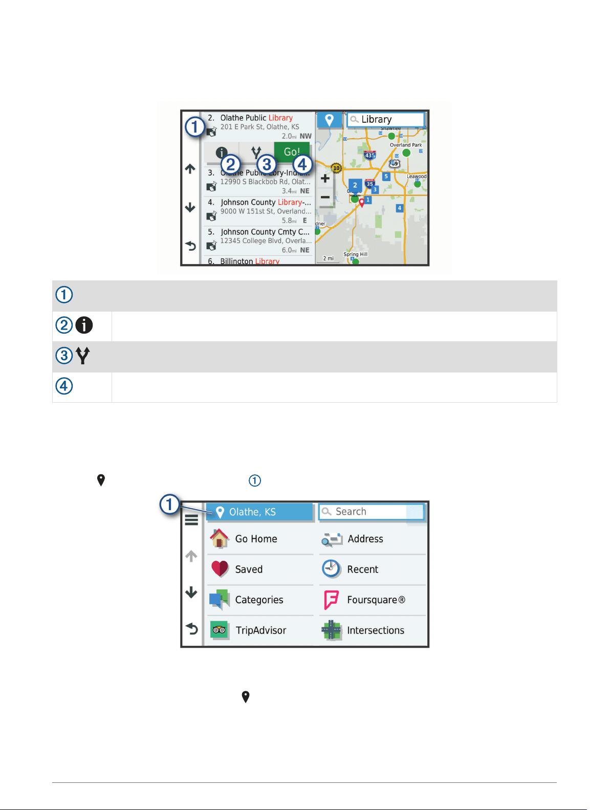
Location Search Results
The location search results appear in a list, with the nearest location at the top. Each numbered location also
appears on the map. You can scroll down to view more results.
Select a location to view the option menu.
Select to view detailed information about the location.
Select to view alternate routes to the location.
Go!
Select to start navigating to the location using the recommended route.
Changing the Search Area
By default, the device searches for locations near your current location. You can also search other areas, such
as near your destination, near another city, or along your active route.
1 Select Where To?.
2 Select next to the current search area .
3 Select a search area.
4 If necessary, follow the on-screen instructions to select a specific location.
The selected search area appears next to . When you search for a location using any of the options in the
Where To? menu, the device suggests locations near this area first.
Finding and Saving Locations 21

Custom Points of Interest
Custom POIs are customized points on the map. They can contain alerts that let you know if you are near a
designated point or if you are traveling faster than a specified speed.
Installing POI Loader
You can create or download custom POI lists on your computer and install them on your device using POI
Loader software.
1 Go to www.garmin.com/poiloader.
2 Follow the on-screen instructions.
Finding Custom POIs
Before you can find custom POIs, you must load custom POIs on your device using the POI Loader software
(Installing POI Loader, page 22).
1 Select Where To? > Categories.
2 Scroll to the Other Categories section, and select a category.
Parking
Your dēzl device includes detailed parking data, which can help you find nearby parking based on the likelihood
of available parking spots, type of parking area, price, or accepted payment methods.
NOTE: Detailed parking data is not available in all areas or for all parking locations.
Finding Truck Parking
1 Select Where To? > Categories > Trucking > Parking Lots.
2 Select a parking location.
3 Select Go!.
Finding Truck Parking in Europe
1 Select Where To? > Truck Parking Europe.
2 If necessary, select Filter by Amenities & Brands, select one or more attributes, and select Search.
3 Select a parking location.
4 Select Go!.
Finding Parking Near Your Current Location
1 Select Where To? > Categories > Parking.
2 Select Filter Parking, and select one or more categories to filter parking by availability, type, price, or
payment methods (optional).
NOTE: Detailed parking data is not available in all areas or for all parking locations.
3 Select a parking location.
4 Select Go!.
Understanding Parking Colors and Symbols
Parking locations that include detailed parking data are color-coded to show the likelihood of finding parking.
Symbols indicate the type of parking available (street or lot), relative pricing information, and payment type.
You can view the legend for these colors and symbols on the device.
From the parking search results, select .
Search Tools
Search tools allow you to search for specific types of locations by responding to on-screen prompts.
22 Finding and Saving Locations

Finding an Intersection
You can search for an intersection or junction between two streets, highways, or other roads.
1 Select Where To? > Intersections.
2 Follow the on-screen instructions to enter street information.
3 Select the intersection.
Finding a Location Using Coordinates
You can find a location using latitude and longitude coordinates. This can be helpful when geocaching.
1 Select Where To? > Coordinates.
2 If necessary, select , and change the coordinate format or datum.
3 Enter the latitude and longitude coordinates.
4 Select View on Map.
Foursquare
Foursquare is a location-based social network. Your device includes pre-loaded Foursquare points of interest,
which are indicated by the Foursquare logo in your location search results.
You can connect to your Foursquare account using the Garmin Drive app on your compatible smartphone. This
allows you to view Foursquare location details, check in to a location, and search for points of interest in the
online Foursquare database.
Connecting to Your Foursquare Account
Before you can use this feature, your device must be connected to a supported phone running the Garmin Drive
app (Pairing with Your Smartphone, page 31).
1 On your smartphone, open the Garmin Drive app.
2 Select > Foursquare.
3 Enter your Foursquare login information.
Searching Foursquare Points of Interest
You can search for Foursquare points of interest loaded on your device. While your device is connected to your
Foursquare account using the Garmin Drive app, the search provides the most up-to-date results from the
online Foursquare database and customized results from your Foursquare user account (Connecting to Your
Foursquare Account, page 23).
Select Where To? > Foursquare.
Viewing Foursquare Location Details
Before you can use this feature, your device must be connected to your Foursquare account using the Garmin
Drive app (Connecting to Your Foursquare Account, page 23).
You can view detailed Foursquare location information, such as user ratings, restaurant pricing information,
and hours of operation.
1 From the location search results, select a Foursquare point of interest.
2 Select .
Tripadvisor
Your device includes Tripadvisor points of interest and ratings. Tripadvisor ratings appear automatically in the
search results list for applicable points of interest. You can also search for nearby Tripadvisor points of interest
and sort by distance or popularity.
Finding and Saving Locations 23

Finding Tripadvisor Points of Interest
1 Select Where To? > TripAdvisor.
2 Select a category.
A list of nearby Tripadvisor points of interest for the category appears.
3 Select Sort Results to sort the search results by distance or popularity (optional).
Viewing Recently Found Locations
Your device stores a history of the last 50 locations you have found.
Select Where To? > Recent.
Clearing the List of Recently Found Locations
Select Where To? > Recent > > Clear > Yes.
Viewing Current Location Information
You can use the Where Am I? page to view information about your current location. This feature is helpful if you
need to tell emergency personnel your location.
From the map, select the vehicle.
Finding Emergency Services and Fuel
You can use the Where Am I? page to find the nearest hospitals, police stations, and fuel stations.
1 From the map, select the vehicle.
2 Select Hospitals, Police Stations, Truck Stops, or Fuel.
NOTE: Some service categories are not available in all areas.
NOTE: When a truck vehicle profile is active, an option for truck stops appears instead of fuel.
A list of locations for the selected service appears, with the nearest locations at the top.
3 Select a location.
4 Select an option:
• To navigate to the location, select Go!.
• To view the phone number and other location details, select .
Getting Directions to Your Current Location
If you need to tell another person how to get to your current location, your device can give you a list of
directions.
1 From the map, select the vehicle.
2 Select > Directions to Me.
3 Select a starting location.
4 Select Select.
Adding a Shortcut
You can add shortcuts to the Where To? menu. A shortcut can point to a location, a category, or a search tool.
The Where To? menu can contain up to 36 shortcut icons.
1 Select Where To? > Add Shortcut.
2 Select an item.
24 Finding and Saving Locations

Removing a Shortcut
1 Select Where To? > > Remove Shortcut(s).
2 Select a shortcut to remove.
3 Select the shortcut again to confirm.
4 Select Done.
Saving Locations
Saving a Location
1 Search for a location (Finding a Location by Category, page 20).
2 From the search results, select a location.
3 Select > Save.
4 Enter a name, and select Done.
Saving Your Current Location
1 From the map, select the vehicle icon.
2 Select Save.
3 Enter a name, and select Done.
4 Select OK.
Editing a Saved Location
1 Select Where To? > Saved.
2 If necessary, select a category.
3 Select a location.
4 Select .
5 Select > Edit.
6 Select an option:
• Select Name.
• Select Phone Number.
• Select Categories to assign categories to the saved location.
• Select Change Map Symbol to change the symbol used to mark the saved location on a map.
7 Edit the information.
8 Select Done.
Assigning Categories to a Saved Location
You can add custom categories to organize your saved locations.
NOTE: Categories appear in the saved locations menu after you have saved at least 12 locations.
1 Select Where To? > Saved.
2 Select a location.
3 Select .
4 Select > Edit > Categories.
5 Enter one or more category names, separated by commas.
6 If necessary, select a suggested category.
7 Select Done.
Finding and Saving Locations 25

Deleting a Saved Location
NOTE: Deleted locations cannot be recovered.
1 Select Where To? > Saved.
2 Select > Delete Saved Places.
3 Select the box next to the saved locations to delete, and select Delete.
Using the Map
You can use the map to navigate a route (Your Route on the Map, page 13) or to view a map of your
surroundings when no route is active.
1 Select View Map.
2 Touch anywhere on the map.
3 Select an option:
• Drag the map to pan left, right, up, or down.
• To zoom in or out, select or .
• To switch between North Up and 3-D views, select .
• To start a route, select a location on the map, and select Go! (Starting a Route by Using the Map, page 12).
Map Tools
Map tools provide quick access to information and device functions while you view the map. When you activate
a map tool, it appears in a panel at the edge of the map.
Stop: Stops navigation of the active route.
Edit Route: Allows you to take a detour or skip locations in your route (Changing Your Active Route, page 16).
Volume: Allows you to customize the sound and notification settings (Sound and Notification Settings,
page 55).
Cities Ahead: Shows upcoming cities and services along your active route or along a highway (Cities Ahead,
page 27).
Up Ahead: Shows upcoming locations along the route or the road on which you are traveling (Up Ahead,
page 27).
Elevation: Displays elevation changes ahead.
Traffic: Displays traffic conditions along your route or in your area (Viewing Upcoming Traffic, page 30). This
feature is not available in all areas or for all device models.
Trip Data: Displays customizable trip data, such as speed or mileage (Viewing Trip Data from the Map,
page 29).
Turns: Displays a list of upcoming turns in your route (Viewing Turns and Directions, page 14).
Phone: Displays a list of recent phone calls from your connected phone, and displays in-call options while a
phone call is active (Using In-Call Options, page 33).
Weather: Displays weather conditions for your area.
photoLive: Displays live traffic cameras from your photoLive subscription (photoLive Traffic Cameras,
page 35).
Report Camera: Allows you to report a speed or red light camera. This tool is available only when you have
speed or red light camera data on your device and you have an active connection to the Garmin Drive app.
Garmin eLog: Displays hours of service information from the Garmin eLog
™
app. Allows you to change duty
status while you are not driving.
PrePass ®: Shows notifications for upcoming weigh stations and bypass decisions (PrePass
®
, page 39).
26 Using the Map

Viewing a Map Tool
1 From the map, select .
2 Select a map tool.
The map tool appears in a panel at the edge of the map.
3 When you are done using the map tool, select .
Up Ahead
The Up Ahead tool provides information about upcoming locations along your route or the road on which you
are traveling. You can view upcoming points of interest by category, such as restaurants, fuel stations, or rest
areas.
You can customize the categories that show in the Up Ahead tool.
Viewing Upcoming Locations
1 From the map, select > Up Ahead.
While you are traveling, the map tool shows the next location along your road or route.
2 Select an option:
• If the map tool shows categories, select a category to view a list of nearby locations in that category.
• If the map tool shows upcoming locations, select a location to view location details or start a route to the
location.
Customizing the Up Ahead Categories
You can change the location categories that appear in the Up Ahead tool.
1 From the map, select > Up Ahead.
2 Select a category.
3 Select .
4 Select an option:
• To move a category up or down in the list, select and drag the arrow next to the category name.
• To change a category, select the category.
• To create a custom category, select a category, select Custom Search, and enter the name of a business
or category.
5 Select Save.
Cities Ahead
While you are traveling on a highway or navigating a route that includes a highway, the Cities Ahead tool
provides information about upcoming cities along the highway. For each city, the map tool shows the distance
to the highway exit and the services available, similar to the information on highway road signs.
Viewing Upcoming Cities and Exit Services
1 From the map, select > Cities Ahead.
While you are traveling along a highway or an active route, the map tool shows information about upcoming
cities and exits.
2 Select a city.
The device shows a list of points of interest located at the selected city exit, such as fuel stations, lodging,
or restaurants.
3 Select a location, and select Go! to start navigating.
Using the Map 27
Warning and Alert Symbols
WARNING
Entering your vehicle profile characteristics does not guarantee that your vehicle's characteristics will be
accounted for in all route suggestions or that you will receive the warning icons in all cases. Limitations may
exist in the map data such that your device cannot account for these restrictions or road conditions in all
cases. Always defer to all posted road signs and road conditions when making driving decisions.
Warning and alert symbols may appear on the map or in route directions to alert you to potential hazards, road
conditions, and upcoming weigh stations.
Restriction Warnings
Height
Weight
Axle Weight
Length
Width
No Trucks Allowed
No Trailers Allowed
No Hazardous Materials Allowed
No Flammables Allowed
No Water Pollutants Allowed
No Left Turn
No Right Turn
No U Turn
28 Using the Map
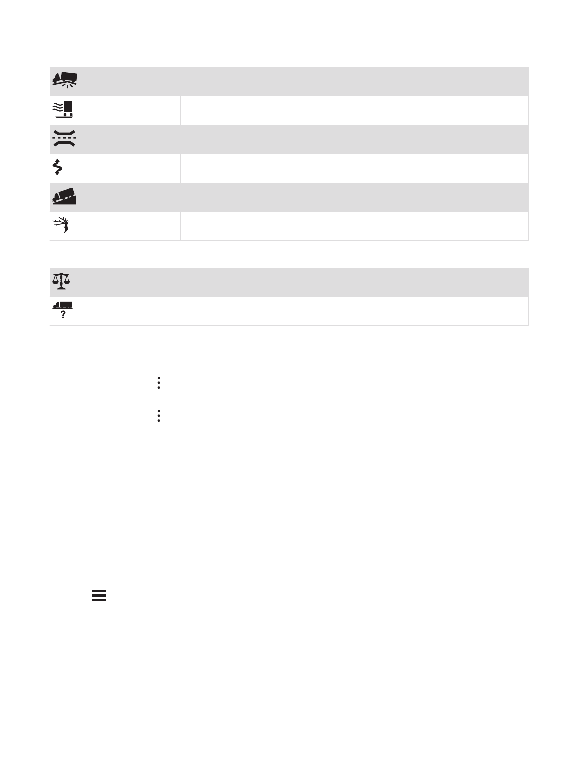
Road Condition Warnings
Risk of grounding
Lateral wind
Narrow road
Sharp curve
Steep down hill
Tree overhang
Alerts
Weigh station
Road not verified for trucks
Trip Information
Viewing Trip Data from the Map
From the map, select > Trip Data.
Customizing the Trip Data Fields
1 From the map, select > Trip Data.
2 Select a trip data field.
3 Select an option.
The new trip data field appears in the trip data map tool.
Viewing the Trip Log
Your device keeps a trip log, which is a record of the path you have traveled.
1 Select Settings > Map and Vehicle > Map Layers.
2 Select the Trip Log check box.
Resetting Trip Information
1 From the map, select Speed.
2 Select a trip information data field.
3 Select > Reset Field(s).
4 Select an option:
• When not navigating a route, select Select All to reset every data field except the speedometer, on the
first page.
• Select Reset Overall Data to reset Trip A and total data.
• Select Reset Max. Speed to reset the maximum speed.
• Select Reset Trip B to reset the odometer.
Using the Map 29

Viewing Upcoming Traffic
NOTICE
Garmin is not responsible for the accuracy or timeliness of the traffic information.
Before you can use this feature, your device must be receiving traffic data (Traffic, page 34).
You can view traffic incidents coming up along your route or along the road on which you are traveling.
1 While navigating a route, select > Traffic.
The nearest upcoming traffic incident appears in a panel on the right side of the map.
2 Select the traffic incident to view additional details.
Viewing Traffic on the Map
The traffic map shows color-coded traffic flow and delays on nearby roads.
1 From the main menu, select > dēzl > Traffic.
2 If necessary, select > Legend to view the legend for the traffic map.
Searching for Traffic Incidents
1 From the main menu, select > dēzl > Traffic.
2 Select > Incidents.
3 Select an item in the list.
4 If there is more than one incident, use the arrows to view additional incidents.
Customizing the Map
Customizing the Map Layers
You can customize which data appear on the map, such as icons for points of interest and road conditions.
1 Select Settings > Map and Vehicle > Map Layers.
2 Select the layers to include on the map, and select Save.
Changing the Map Data Field
1 From the map, select a data field.
NOTE: You cannot customize Speed.
2 Select a type of data to display.
Changing the Map Perspective
1 Select Settings > Map and Vehicle > Driving Map View.
2 Select an option:
• Select Track Up to display the map in two dimensions (2-D), with your direction of travel at the top.
• Select North Up to display the map in 2-D with north at the top.
• Select 3-D to display the map in three dimensions.
3 Select Save.
30 Using the Map

Live Services, Traffic, and Smartphone Features
The Garmin Drive app allows your device to receive smart notifications and live information, such as live traffic
data and weather information.
Live traffic data: Sends real-time traffic data to your device, such as traffic incidents and delays, construction
zones, and road closings (Traffic, page 34).
Weather information: Sends real-time weather forecasts, road conditions, and weather radar to your device
(Viewing the Weather Forecast, page 52).
Smart Notifications: Displays phone notifications and messages on your device. This feature is not available
for all languages.
Hands-Free calling: Allows you to place and receive phone calls using your device, and allows you to use the
device as a hands-free speaker phone. If the selected language supports the voice command feature, you
can place calls using voice commands.
Send locations to device: Allows you to send locations from your smartphone to your navigation device.
Foursquare check in: Allows you to check in to Foursquare locations using your navigation device.
Pairing with Your Smartphone
You can pair your dēzl device with your smartphone and the Garmin Drive app to enable additional features and
access live information (Live Services, Traffic, and Smartphone Features, page 31).
1 From the app store on your smartphone, install the Garmin Drive app.
2 Turn on your dēzl device, and place the device and your smartphone within 3 m (10 ft.) of each other.
3 On your phone, open the Garmin Drive app.
4 Follow the on-screen instructions to sign in to a Garmin account and complete the pairing and setup
process.
The main app dashboard appears. After the devices are paired, they connect automatically when they are
turned on and within range.
Tips After Pairing the Devices
• After the initial pairing, the two devices can connect automatically each time you turn them on.
• When your phone is connected to your device, you are ready to receive voice calls.
• When you turn on the device, it tries to connect to the last phone to which it was connected.
• You might need to set your phone to connect to the device automatically when the device is turned on.
• To place phone calls, the contact sharing permission must be enabled for the navigation device in the
Bluetooth settings on your phone.
• You should verify the Bluetooth features you want to use are enabled (Enabling or Disabling Bluetooth
Features, page 33).
Pairing Additional Bluetooth Devices
1 Place your headset or phone and your Bluetooth device within 33 ft. (10 m) of each other.
2 On your device, enable Bluetooth wireless technology.
3 On your headset or phone, enable Bluetooth wireless technology and ensure it is visible to other Bluetooth
devices.
4 On your device, select Settings > Bluetooth.
A list of nearby Bluetooth devices appears.
5 Select your headset or phone from the list.
6 If necessary, select Pair.
Live Services, Traffic, and Smartphone Features 31

Going to an Address or Location Using the Garmin Drive App
You can use the Garmin Drive app to search for an address, business, or point of interest, and send it to your
dēzl device for navigation.
1 From the Garmin Drive app, select Where To?.
2 Select an option:
• To search for an address near you, enter the house number and street name.
• To search for an address in another city, enter the house number, street name, city, and state.
• To search for a business name, enter all or part of the name.
• To search for a city, enter the city and state.
As you type, suggestions appear below the search field.
3 Select a suggested search result.
The app displays the location on a map.
4 Select Go! to start a route.
The dēzl device starts navigating to the selected location, and the location is added to your recent searches in
the Where To? menu.
Smart Notifications
While your device is connected to the Garmin Drive app, you can view notifications from your smartphone on
your dēzl device, such as text messages, incoming calls, and calendar appointments.
Receiving Notifications
WARNING
Do not read or reply to notifications while driving. If you do so, you could become distracted by the display,
which could lead to an accident causing serious personal injury or death.
Before you can use this feature, your device must be connected to a supported phone running the Garmin Drive
app.
From most pages, a popup appears when the device receives a notification from your smartphone. If the device
is moving, you must verify you are a passenger and not the driver before you can view notifications.
NOTE: If you are viewing the map, notifications appear in a map tool.
• To ignore a notification, select OK.
The popup closes, but the notification remains active on your phone.
• To view a notification, select View.
• To listen to the notification, select View > Play.
The device reads the notification using text-to-speech technology. This feature is not available for all
languages.
• To perform additional actions, such as dismissing the notification from your phone, select View, and select
an option.
NOTE: Additional actions are available for only some notification types and must be supported by the app
generating the notification.
Hands-Free Calling
NOTE: While most phones and headsets are supported and can be used, a particular phone or headset cannot
be guaranteed to be compatible. All features may not be available for your phone.
Using Bluetooth wireless technology, your device can connect to your compatible mobile phone and wireless
headset or helmet to become a hands-free device. To check compatibility, go to www.garmin.com/bluetooth.
32 Live Services, Traffic, and Smartphone Features

Placing a Call
1 Select .
2 Select an option:
• To dial a number, select , enter the phone number, and select .
• To call a recently dialed or received phone number, select , and select a number.
• To call a contact from your phone book, select , and select a contact.
Receiving a Call
When you receive a call, select Answer or Dismiss.
Using In-Call Options
In-call options appear when you answer a call. Some options may not be compatible with your phone.
TIP: If you close the in-call options page, you can open it again by selecting from the main menu.
• To set up a conference call, select the caller ID, and select .
• To transfer audio to your phone, select .
TIP: You can use this feature if you want to disconnect the Bluetooth connection and remain on the call, or if
you need privacy.
• To use the dial pad, select the caller ID, and select .
TIP: You can use this feature to use automated systems, such as voice mail.
• To mute the microphone, select .
• To hang up, select .
Saving a Phone Number as a Preset
You can save up to three contacts as presets on the dial pad. This allows you to quickly call your home phone
number, family members, or frequently called contacts.
1 Select > .
2 Hold a preset number, such as Preset 1.
3 Select a contact.
Wireless Headsets
Your device can send audio navigation prompts to a Bluetooth enabled wireless headset.
Enabling or Disabling Bluetooth Features
You can enable or disable hands-free calling and Garmin Drive features for your paired smartphone.
1 Select Settings > Wireless Networks > Bluetooth.
2 Select next to your phone name.
3 In the Use for section, select an option:
• To enable a connection to the Garmin Drive app, select Garmin Drive.
• To enable hands-free calling features, select Hands-Free.
4 Select OK.
Showing or Hiding App Notifications (Android
™
)
You can use the Garmin Drive app to customize which types of smartphone notifications appear on your dēzl
device.
1 On your phone, open the Garmin Drive app.
2 Select > Smart Notifications.
A list of your smartphone apps appears.
3 Select the toggle switch next to an app to enable or disable notifications for the app.
Live Services, Traffic, and Smartphone Features 33

Showing or Hiding Notification Categories for Your Apple
®
Device
If you are connected to an Apple device, you can filter the notifications shown on your dēzl device by showing
or hiding categories.
1 Select > Tools > Smart Notifications > .
2 Select the check box next to each notification to show.
Disconnecting a Bluetooth Device
You can temporarily disconnect a Bluetooth device without deleting it from the paired devices list. The
Bluetooth device can connect to your dēzl device automatically in the future.
1 Select Settings > Wireless Networks > Bluetooth.
2 Select the device to disconnect.
3 Select OK.
Deleting a Paired Bluetooth Device
You can delete a paired Bluetooth device to prevent it from automatically connecting to your dēzl device in the
future. Deleting a paired smartphone also deletes all synced phonebook contacts and call history from your
dēzl device.
1 Select Settings > Bluetooth.
2 Next to the Bluetooth device name, select > Forget.
Deleting a Paired Phone
You can delete a paired phone to prevent it from automatically connecting to your device in the future.
1 Select Settings > Bluetooth.
2 Next to the phone name, select > Forget.
Traffic
NOTICE
Garmin is not responsible for the accuracy or timeliness of the traffic information.
Your device can provide information about traffic on the road ahead or on your route. You can set your device
to avoid traffic when calculating routes, and to find a new route to your destination if a large traffic delay
occurs on your active route (Traffic Settings, page 55). The traffic map allows you to browse the map for
traffic delays in your area.
To provide traffic information, your device must be receiving traffic data.
• All product models can receive subscription-free traffic data using the Garmin Drive app (Receiving Traffic
Data Using Your Smartphone, page 34).
Traffic data is not available in all areas. For information about traffic coverage areas, go to garmin.com/traffic.
Receiving Traffic Data Using Your Smartphone
Your device can receive subscription-free traffic data while connected to a smartphone running the Garmin
Drive app.
1 Connect your device to the Garmin Drive app.
2 On your dēzl device, select Settings > Traffic, and verify the Traffic option is selected.
Viewing Traffic on the Map
The traffic map shows color-coded traffic flow and delays on nearby roads.
1 From the main menu, select > dēzl > Traffic.
2 If necessary, select > Legend to view the legend for the traffic map.
34 Traffic

Searching for Traffic Incidents
1 From the main menu, select > dēzl > Traffic.
2 Select > Incidents.
3 Select an item in the list.
4 If there is more than one incident, use the arrows to view additional incidents.
photoLive Traffic Cameras
Before you can use this feature, your device must be connected to the Garmin Drive app (Pairing with Your
Smartphone, page 31).
photoLive traffic cameras provide live images of traffic conditions on major roadways and intersections.
The photoLive service is not available in all areas.
Viewing and Saving photoLive Traffic Cameras
You can view live images from nearby traffic cameras. You can also save traffic cameras for areas you travel
frequently.
1 Select > photoLive.
2 Select Touch to Add
3 Select a road.
4 Select a traffic camera location.
A preview of the live image from the camera appears next to a map of the camera's location. You can select
the image preview to view the full-sized image.
5 Select Save to save the camera (optional).
A thumbnail image preview of the camera is added to the main screen of the photoLive app.
Saving a Traffic Camera
1 Select > photoLive.
2 Select Touch to Add.
3 Select a traffic camera.
4 Select Save.
Vehicle and Driver Tools
Break Planning
NOTICE
This device by itself is NOT an approved substitute for logbook recording requirements under Federal Motor
Carrier Safety Administration (FMCSA) regulations. Drivers should comply with all applicable federal and state
hours-of-service requirements. When integrated with a Garmin eLog compliant Electronic Logging Device (ELD),
this device enables a motor carrier to comply with hours of service logging and break requirements. For more
information, or to purchase a Garmin eLog device, go to garmin.com/elog.
When the break planning feature is enabled, the device notifies you one hour before suggested break times and
drive hour limits and suggests break locations on your route. You can use this feature to keep track of your
working hours, which may help you comply with safety regulations.
NOTE: Break planning features are not available when using the car vehicle profile.
Taking a Suggested Break
When it is time for a break, the device notifies you and displays suggested break location POIs along your route.
Select a POI from the list of suggested break locations.
The device adds the break location as the next destination on your route.
Vehicle and Driver Tools 35

Starting the Break Timer
The break timer starts automatically when the vehicle is moving at least 8 kph (5 mph) for 30 seconds. You can
start the timer manually at any time.
1 From the map, select > Break Planner.
2 Select Start Timer.
Pausing and Resetting the Break Timer
The break timer pauses automatically when the vehicle stops for three minutes or longer. You can pause the
timer manually for brief stops, such as parking or stopping at a truck stop. At the end of your drive, you can
manually reset the timer.
1 Select Stop Timer.
2 Select an option:
• To pause the timer, select Pause.
• To stop and reset the timer, select Reset.
Adjusting Drive Hours
You can adjust your total hours driven to more closely match your hours of service records.
1 While using the break planner feature, select Total Hours Driven.
2 Enter the total hours driven.
3 Select Save.
Adjusting the Daily Driving Limit
You can adjust the daily driving limit to correspond with legal requirements in your area.
NOTE: This feature is not available in all areas.
1 While using the break planner feature, select Daily Hours Driven.
2 Select the daily driving limit for your area.
3 Select Save.
IFTA
NOTE: This feature is not available in all areas.
Before you can use this feature, a truck vehicle profile must be active.
You can record data needed for International Fuel Tax Agreement documentation (IFTA), such as fuel-purchase
data and miles driven.
Entering Fuel Data
1 Select > IFTA > At the Pump.
2 Enter the fuel price per gallon.
3 Select the Fuel Used field.
4 Enter the amount of fuel purchased.
5 If necessary, select the fuel type:
• To record the amount in liters, select Gallons > Liters > Save.
• To record the amount in gallons, select Liters > Gallons > Save.
6 If necessary, select the Tax Included check box.
7 Select Next.
8 Select an option to record the fuel station where you refueled:
• Select a nearby fuel station from the list.
• Select the text field, and enter the fuel station name and address.
9 Select the fuel purchaser.
36 Vehicle and Driver Tools

Editing Fuel Data
1 Select > IFTA > Fuel Journals.
2 If necessary, select a vehicle profile.
3 If necessary, select a quarter.
4 Select a fuel record.
5 Select an option:
• Select a field to edit the information.
• Select to delete the record.
Viewing and Exporting a Jurisdiction Summary
The jurisdiction summary lists data for each state or province in which your vehicle has operated during each
quarter. The jurisdiction summary is available in some areas.
1 Select > IFTA > Jurisdiction Summary.
2 If necessary, select a truck.
3 If necessary, select a quarter.
4 Select > Export > OK to export a jurisdiction summary.
The device exports the summary to a .csv file and stores it in the Reports folder on the device.
Editing and Exporting Trip Reports
1 From the main menu, select > IFTA > Trip Reports.
2 If necessary, select a truck.
3 If necessary, select a quarter.
4 Select a report.
5 Select an option:
• Select > Delete, and select the check box to delete a report.
• Select > Combine, and select the check boxes to combine reports.
• Select > Export > OK. The device exports the report to a .csv file and stores it in the Reports folder on
the device.
Viewing Exported Jurisdiction Summaries and Trip Reports
NOTICE
If you do not know the purpose of a file, do not delete it. Your device memory contains important system files
that should not be deleted.
1 Connect the device to your computer.
2 From the file browser on your computer, browse to the internal device storage, and open the Reports folder.
3 Open the IFTA folder.
4 Open the .csv file.
Vehicle and Driver Tools 37

Logging Service History
You can log the date and odometer reading when service or maintenance is performed on your vehicle. The
device provides several service categories, and you can add custom categories (Adding Service Categories,
page 38).
1 Select > Service History.
2 Select a service category.
3 Select Add Record.
4 Enter the odometer reading, and select Next.
5 Enter a comment (optional).
6 Select Done.
Adding Service Categories
1 Select > Service History.
2 Select > Add Category.
3 Enter a category name, and select Done.
Deleting Service Categories
When you delete a service category, all service records in the category are also deleted.
1 Select > Service History.
2 Select > Delete Categories.
3 Select the service categories to delete.
4 Select Delete.
Renaming Service Categories
1 Select > Service History.
2 Select the category to be renamed.
3 Select > Rename Category.
4 Enter a name, and select Done.
Deleting Service Records
1 Select > Service History.
2 Select a service category.
3 Select > Delete Records.
4 Select the service records to be deleted.
5 Select Delete.
Editing a Service Record
You can edit the comment, odometer reading, and date of a service record.
1 Select > Service History.
2 Select a category.
3 Select a field.
4 Enter the new information, and select Done.
38 Vehicle and Driver Tools

PrePass
®
NOTICE
Garmin is not responsible for the accuracy or timeliness of the information provided by the PrePass app.
NOTE: Before you can use this feature, you must have an active PrePass account.
The PrePass app enables drivers to verify the safety, credentials, and weight of a commercial vehicle with
upcoming weigh stations. You can pair your dēzl device with the Garmin Drive app and the PrePass app to
receive upcoming weigh station notifications on your dēzl device.
NOTE: This feature is available only in the United States.
Garmin eLog
The Garmin eLog adapter enables a motor carrier to comply with FMCSA Electronic Logging Device
(ELD) regulations. When the dēzl device is paired with the Garmin eLog adapter, the dēzl device and the Garmin
eLog adapter together provide a complete ELD solution without the need for an additional smartphone or
mobile device. You can use your dēzl device to record and view hours of service information, change your duty
status, create inspection reports, and more.
The Garmin eLog adapter is not available in all areas. For more information, or to purchase a Garmin eLog
adapter, go to garmin.com/elog.
Setting Up Your Garmin eLog Adapter
NOTE: If you need to transfer Garmin eLog data from another device to your dēzl device , you must import the
data during the setup process. You should create a data backup from your previous device before you start
setting up the Garmin eLog adapter on your dēzl device (Transferring Garmin eLog Data from Another Device,
page 39).
You must set up and pair your Garmin eLog adapter with the Garmin eLog app in order to be in compliance with
FMCSA ELD regulations. For more information about installing the Garmin eLog adapter in your vehicle, see the
Garmin eLog Owner's Manual at garmin.com/manuals/elog.
1 On your dēzl device, open the Garmin eLog app.
2 Follow the instructions in the app to set up and configure the Garmin eLog system, administrator account,
and driver profiles.
NOTICE
The administrator account is critical for some app functions. Choose an administrator password you can
remember, and do not lose the password. The administrator password cannot be recovered without clearing
all app data, which causes all recorded Garmin eLog data to be deleted.
NOTE: Until you complete the setup process, the Garmin eLog device has limited functionality and is not
compliant with FMCSA ELD regulations.
Transferring Garmin eLog Data from Another Device
If you have previously used your Garmin eLog adapter with another device, you can transfer the Garmin eLog
app data from the previous device to your dēzl device. You must complete this transfer during the initial setup.
1 From the Garmin eLog app on your previous device, create a data backup (Backing Up Data, page 40).
2 While setting up your Garmin eLog adapter with your dēzl device, restore the data backup (Restoring Data,
page 40).
Garmin eLog 39

Backing Up Data
You can back up your recorded data to a USB storage device. You should back up regularly to help prevent data
loss. This is also useful when you need to transfer data to another device.
1 From the Garmin eLog app, select Settings > Back Up Data.
2 Insert a USB storage device into the USB port on the Garmin eLog adapter.
The light ring on the adapter glows green and plays a tone when it is ready to back up data.
3 Select Back Up Data.
Restoring Data
You can restore backed up data from a USB storage device. This can be useful when transferring Garmin eLog
app data from another device.
NOTE: You can restore backed up data only while your are setting up the Garmin eLog app.
1 Open the Garmin eLog app to start the setup process.
2 Follow the on-screen instructions to install the Garmin eLog adapter in the vehicle diagnostic port and
complete the pairing process.
3 Select Restore from Backup.
4 Insert a USB storage device containing backup files into the USB port on the Garmin eLog adapter.
The light ring on the adapter glows green and plays a tone when it is ready to restore data.
5 Select a backup file.
6 Select Restore.
Daily Operation Guidelines
The following points are guidelines to follow when using the Garmin eLog system. Your motor carrier may have
different operation requirements. Follow your motor carrier's recommendations for daily operation.
• Verify the dēzl is securely mounted in the vehicle and its screen is visible from a normal seated position.
• Verify Bluetooth wireless technology and location services are enabled on your device at all times while
using the Garmin eLog adapter.
• Verify the Garmin eLog app is running and the Garmin eLog adapter is secured to the vehicle diagnostic port
before starting the vehicle.
• Log in to the Garmin eLog app at the start of each day.
• Review and claim all logs recorded for an unidentified driver, if applicable.
• At the end of each work day, log out of the Garmin eLog app after turning off the engine.
• Certify your records, and submit them to your motor carrier at the end of each day (Certifying Daily Logs,
page 44).
Starting a Drive
Each time you drive your vehicle, you should complete these actions to ensure your hours of service
information is recorded correctly.
1 Verify the Garmin eLog adapter is secured to the vehicle diagnostic port.
For more information about installing the Garmin eLog adapter in your vehicle, see the Garmin eLog Owner's
Manual at garmin.com/manuals/elog.
2 Open the Garmin eLog app, and log in as the driver.
3 Start your vehicle.
4 Before you start driving, change your duty status in the Garmin eLog app.
The Garmin eLog adapter syncs with the Garmin eLog app and records ELD Records of Duty Service (RODS)
automatically.
40 Garmin eLog
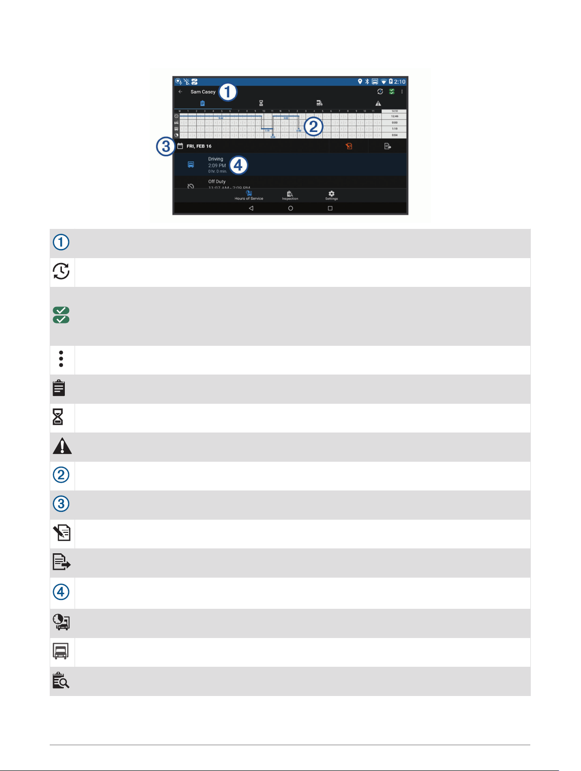
Garmin eLog App Overview
The name of the active driver.
Select to change duty status.
Diagnostic and malfunction indicator. Select to view detailed information about diagnostic or malfunc
tion alerts (Viewing Diagnostics and Malfunctions, page 46).
NOTE: The diagnostic and malfunction indicator also appears in the status bar or near the top of every
screen on your dēzl device.
Select to record adverse conditions, create a Records of Duty Status (RODS) report, or log out.
Select to view a chart of your hours of service information.
Select to view a summary of currently available on-duty hours.
Select to review log information.
Select to view a full-screen chart of your service hours.
Select to review logs for a different day.
Select to certify your logs for the selected day.
Select to submit a 24-hour log to your motor carrier.
A record of your status for the recorded time period. Select to edit status information and adjust the
time.
Select to view hours of service information.
Select to manage trailer and shipment information or to create a driver vehicle inspection report.
Select to view inspection reports and transfer reports to a roadside inspector.
Garmin eLog 41
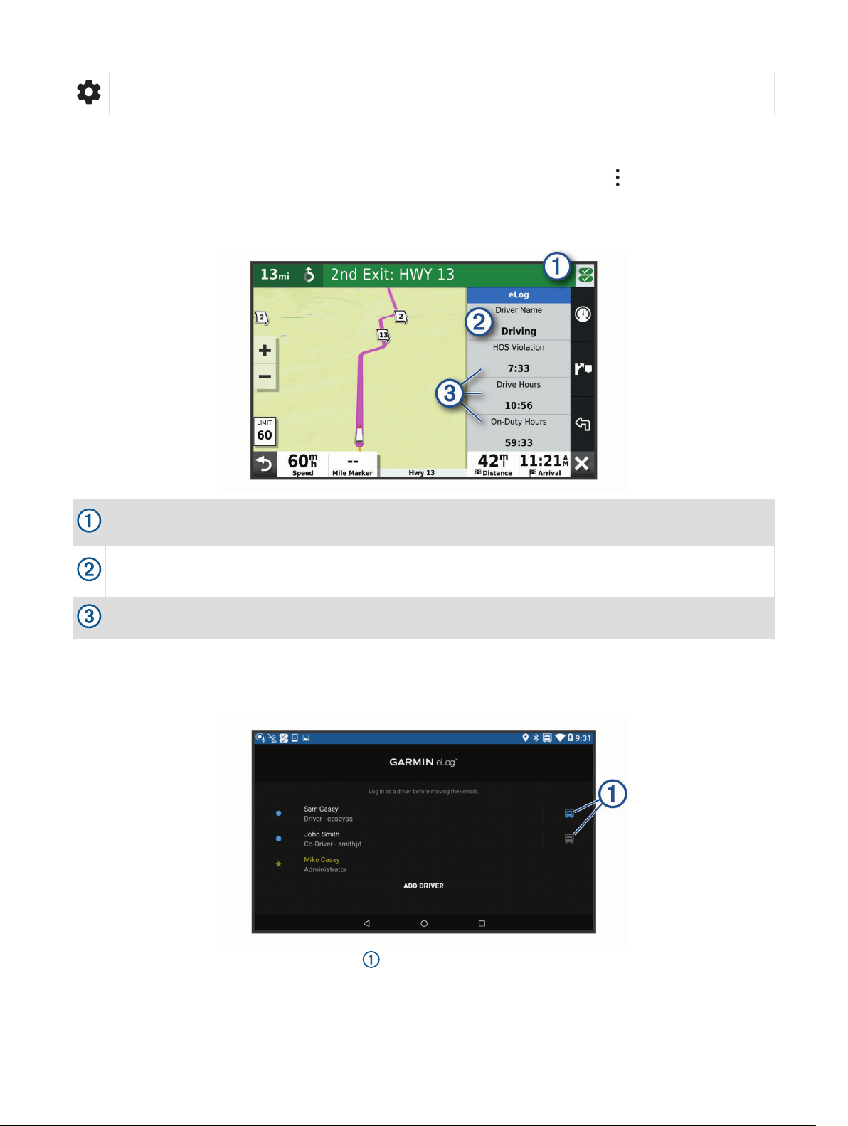
Select to view additional system settings.
Garmin eLog Map Tool Overview
The Garmin eLog map tool appears on the navigation map automatically while your device is connected to a
Garmin eLog adapter. If you close the map tool, you can open it manually by selecting > Garmin eLog from
the map.
As you drive, the device displays your duty status and hours of service information in the Garmin eLog map
tool.
Diagnostic and malfunction indicator. Select to view detailed information about diagnostic or malfunc
tion alerts (Viewing Diagnostics and Malfunctions, page 46).
Driver name and duty status. Select to change the driver's duty status (Changing Duty Status, page 43).
NOTE: You cannot change your duty status while driving.
Current remaining drive hours. Select to view detailed drive hours information in the Garmin eLog app.
Driving in a Team
If you are driving in a team, you can switch between active drivers at any time. Each driver must log in to the
Garmin eLog app before they can be set as the active driver.
From the Garmin eLog app, select the icon next to the user who should be listed as the active driver.
42 Garmin eLog

Changing Duty Status
For the most accurate records, you must change your duty status in the Garmin eLog app every time you
change your driving status, such as when you start driving, take a break, switch drivers, or change the type of
driving you are doing. The Garmin eLog adapter automatically switches to driving status when the vehicle's
diagnostic port reports a speed greater than or equal to five miles per hour. The vehicle is stopped when the
diagnostic port reports a speed of zero miles per hour.
NOTE: The vehicle must be stopped to change duty status. You cannot manually change duty status while you
are driving.
1 Select an option:
• From the Garmin eLog app, select .
• From the Garmin eLog map tool, select the driver name.
2 Select an option:
NOTE: The Personal Conveyance and Yard Moves options are available only if the administrator has enabled
them for your driver profile (Editing a Driver Profile, page 49).
• If you are on duty, select On Duty.
• If you are off duty, select Off Duty.
• If you are on duty and driving, select Driving.
• If you are moving to the sleeper berth, select Sleeper Berth.
• If you are using the vehicle for personal conveyance, select Personal Conveyance.
• If you are moving the vehicle within the yard, select Yard Moves.
Editing a Duty Status Record
You can update individual duty status entries to make corrections or updates to your duty status history as
allowed by FMCSA regulations. This can be useful if you forget to change your duty status.
1 From the Garmin eLog app, select the duty status record for the affected time period.
2 Select Duty Status.
3 Select the correct duty status for the time period.
4 If necessary, update the start and end times for the duty status entry.
5 If necessary, enter the location where this duty status was active.
6 Enter an annotation describing the reason for the change.
7 Select Save.
Viewing Hours of Service
1 From the Garmin eLog app, select HOS.
2 Select an option:
• To view a chart of your hours of service information, select .
TIP: You can select the chart to view a larger image of your information.
• To view a list of remaining drive hours, select .
Recording Adverse Conditions
If you require a time extension because of adverse conditions, you can add a two-hour extension to your hours
for the day.
From the Garmin eLog app, select > Record Adverse Conditions > Yes.
Garmin eLog 43

Reviewing Logs
The Garmin eLog app keeps track of logs that may require review, including logs that have been edited or logs
that exist for an unidentified driver. When a driver logs in, the app prompts them to review logs that contain an
unidentified driver, if any are available. Drivers are responsible for reviewing and claiming logs, if applicable.
1 Select HOS > .
2 Select a log.
3 Select an option:
• If the log applies to you and your hours of service, select Accept.
• If the log does not apply to you, select Decline.
Certifying Daily Logs
After you are finished driving for the day, you should certify your daily log. If you update your duty status after
certifying it, you must certify it again.
From the Garmin eLog app, select > Agree.
Submitting a Daily Log
You can submit a daily log to your motor carrier.
1 From the Garmin eLog app, select .
2 Select an option to share your exported log.
Exporting and Saving a Record of Duty Status (RODS) Report
You can create a RODS report so you or your motor carrier can open your records of duty status outside of the
Garmin eLog app.
1 From the Garmin eLog app, select > Create RODS Report.
2 If necessary, select Create Additional Graph Grid Report to include a graph grid in your RODS report.
3 Select an option:
• To save the report to the internal storage of your dēzl device, select Save Report.
• To export the report to email, select Export Report.
Recording Trailers and Shipments
You can use the Garmin eLog app to keep records of trailers and shipments.
1 Select Vehicle > .
2 Select an option:
• To add a trailer, select Add Trailer.
• To add a shipment, select Add Shipment.
3 Enter the trailer number or shipping document number.
Roadside Inspection
Viewing Inspection Information
An authorized safety official may ask to view all information recorded by the Garmin eLog system for the
current 24-hour period and any of the previous seven consecutive days. You can view this information on the
Garmin eLog app at any time.
From the Garmin eLog app, select Inspection.
44 Garmin eLog

Transferring Data to an Inspector Using a USB Device
You can transfer data to a USB mass storage device to provide it to an authorized safety official. The Garmin
eLog adapter supports USB mass storage devices formatted using the FAT32 file system.
1 From the Garmin eLog app, select Inspection.
2 Select > Yes.
3 If necessary, enter an annotation.
4 Select USB.
5 Connect a USB mass storage device to the USB port on your Garmin eLog adapter.
The adapter glows green when it is ready to send the inspection report.
6 Enter your password.
7 Select Send to USB Device.
The Garmin eLog app notifies you when the transfer is complete.
8 Remove the USB mass storage device from the adapter.
Transferring Data to an Inspector Using Bluetooth Wireless Technology
The inspector's device must support the Bluetooth Personal Area Networking (PAN) profile and must be able to
connect to FMCSA Web Services to complete transfers using Bluetooth wireless technology. Ensure that
Bluetooth wireless technology and a Wi-Fi hotspot are enabled on the inspector's mobile device.
The Garmin eLog device uses the inspector's mobile device as a network access point to send inspection
information to FMCSA web services.
1 From the Garmin eLog app, select Inspection.
2 Select > Yes.
3 If necessary, enter an annotation.
4 Select Bluetooth.
5 Select Enable Pairing Mode.
6 Follow the on-screen instructions in the app to pair the Garmin eLog adapter with the inspector's mobile
device.
The inspection report transfers automatically after the pairing process is complete.
Diagnostics and Malfunctions
The Garmin eLog app records malfunctions and diagnostic events when the app detects critical functions that
do not conform to Federal Motor Carrier Safety Administration (FMCSA) specifications. When a malfunction is
detected, the driver and motor carrier are subject to responsibilities as directed by FMCSA guidelines.
Driver Responsibilities
• The driver must note the malfunction of the ELD and provide written notice of the malfunction to the motor
carrier within 24 hours.
• The driver must reconstruct the Record of Duty Status (RODS) for the current 24-hour period and the
previous 7 consecutive days, and record the records of duty status on graph-grid paper logs that comply with
49 CFR 395.8, unless the driver already has the records or retrieves them from the ELD.
• The driver must continue to manually prepare RODS in accordance with 49 CFR 395.8 until the ELD is
serviced and returned to a compliant status.
Motor Carrier Responsibilities
• The motor carrier must correct, repair, replace, or service the malfunctioning ELD within eight days of
discovering the condition or a driver's notification to the motor carrier, whichever occurs first.
• The motor carrier must require the driver to maintain a paper RODS record until the ELD is back in service.
Garmin eLog 45

Viewing Diagnostics and Malfunctions
If the Garmin eLog adapter detects a diagnostic event or malfunction, an alert and an indicator appear in the
app. A diagnostic and malfunction indicator also appears in the status bar or near the top of every screen.
No diagnostic events or malfunctions are detected.
A diagnostic event was detected.
A malfunction was detected.
Diagnostic events and malfunctions were detected.
You can view information about these alerts at any time. This can be useful for correcting errors or adjusting
driver information.
Select the diagnostic or malfunction indicator.
The app displays information about the diagnostic or malfunction alert and provides recommendations for how
to correct it.
46 Garmin eLog

Diagnostic Definitions
Power Data Diagnostic Event: The adapter did not receive power, or was not fully functional, for a period of
time.
1
Check the vehicle diagnostic port connections.
2
Verify the adapter is firmly plugged into the vehicle diagnostic port.
3
Review all affected driver logs for missing or incorrect data.
Engine Synchronization Data Diagnostic Event: The adapter failed to synchronize with the vehicle engine
computer to record required engine data for driver logs.
1
Check the vehicle diagnostic port connections.
2
Verify the adapter is firmly plugged into the vehicle diagnostic port.
3
Review all affected driver logs for missing or incorrect data.
Missing Required Data Elements Data Diagnostic Event: The Garmin eLog system failed to obtain one or more
required data elements when recording driver logs.
1
Check the vehicle diagnostic port connections.
2
Verify the adapter is firmly plugged into the vehicle diagnostic port.
3
Check the Bluetooth settings on the device running the Garmin eLog app, and verify the device and the
adapter are connected.
4
Check the GPS settings on the device running the Garmin eLog app, and verify the device settings allow
location positions to be shared with the Garmin eLog app.
5
Review all affected driver logs for missing or incorrect data.
Data Transfer Data Diagnostic Event: A failure occurred with the method for transferring roadside inspection
reports.
Perform the following actions:
1
Check the Bluetooth settings on the device running the Garmin eLog app, and verify the device and the
adapter are connected.
2
Verify all USB storage devices used to transfer roadside inspection reports are operating correctly.
3
If you have not performed a data backup within the previous seven days, back up your recorded Garmin
eLog data to a USB storage device.
Unidentified Driving Records Data Diagnostic Event
Unidentified Driving Records Data Diagnostic Event: At least 30 minutes of unidentified driving was recorded
within the current 24 hour period, and over the previous 7 days.
• Drivers: Review and claim the unidentified driving time.
• Administrator: Review and assign the unidentified driving time to the respective drivers.
Garmin eLog 47

Malfunction Definitions
Power Compliance Malfunction: The adapter did not receive power, or was not fully functional, for a period of
time. At least 30 minutes of driving time may not have been correctly recorded across all drivers over the
past 24 hours.
1
Check the vehicle diagnostic port connections.
2
Verify the adapter is firmly plugged into the vehicle diagnostic port.
3
Review all affected driver logs for missing or incorrect data.
Engine Synchronization Compliance Malfunction: The adapter failed to synchronize with the vehicle engine
computer to record required engine data for driver logs. At least 30 minutes of inaccurate data may have
been recorded across all drivers over the past 24 hours.
1
Check the vehicle diagnostic port connections.
2
Verify the adapter is firmly plugged into the vehicle diagnostic port.
3
Review all affected driver logs for missing or incorrect data.
Timing Compliance Malfunction: The Garmin eLog system failed to accurately verify the calendar date or time
of day required for driver logs.
1
Verify the adapter is firmly plugged into the vehicle diagnostic port.
2
Check the Bluetooth settings on the device running the Garmin eLog app, and verify the device and the
adapter are connected.
3
Check the date and time settings on the device running the Garmin eLog app.
4
Review all affected driver logs for missing or incorrect data.
Positioning Compliance Malfunction: The Garmin eLog system failed to acquire valid location positions
required for driver logs. At least 60 minutes of inaccurate data may have been recorded across all drivers
over the past 24 hours.
1
Verify the Garmin eLog app is running and a driver is logged in when driving the vehicle.
2
Check the Bluetooth settings on the device running the Garmin eLog app, and verify the device and the
adapter are connected.
3
Check the GPS settings on the device running the Garmin eLog app, and verify the device settings allow
location positions to be shared with the Garmin eLog app.
4
Review all affected driver logs for missing or incorrect data.
Data Recording Compliance Malfunction: The Garmin eLog system has reached the maximum storage
capacity for driver logs and cannot store or retrieve more logs.
1
Create a RODS report for each driver for record keeping (Exporting and Saving a Record of Duty Status
(RODS) Report, page 44).
2
Log in as an administrator.
3
Back up the system data (Backing Up Data, page 40).
4
Remove unneeded files from the storage of the device running the Garmin eLog app.
Data Transfer Compliance Malfunction: Multiple failures occurred with the method for transferring roadside
inspection reports.
Perform the following actions:
1
Check the Bluetooth settings on the device running the Garmin eLog app, and verify the device and the
adapter are connected.
2
Verify all USB storage devices used to transfer roadside inspection reports are operating correctly and are
formatted using the FAT32 file system.
3
If you have not performed a data backup within the previous seven days, back up your recorded Garmin
eLog data to a USB storage device.
Adapter Firmware Malfunction: A serious error occurred attempting to update the adapter firmware. Contact
Garmin customer support for further help.
Outdated adapter firmware may not maintain compliance. Garmin recommends keeping paper logs until the
adapter firmware is successfully updated.
48 Garmin eLog

Administrator Functions
NOTICE
The administrator account is critical for some app functions. Choose an administrator password you can
remember, and do not lose the password. The administrator password cannot be recovered without clearing all
app data, which causes all recorded Garmin eLog data to be deleted.
You must use the administrator account to perform some Garmin eLog app functions, including adding driver
profiles, editing driver profiles, and resetting driver passwords. The administrator account and password are
created during the initial Garmin eLog app setup. If the app is administered by a company, drivers may not have
access to the administrator functions.
Adding Driver Profiles
You must log in as an administrator to add driver profiles.
1 From the Garmin eLog app, select Add Driver.
2 Enter the administrator password.
3 Enter the driver and motor carrier information.
4 If the driver has an exempt status, select Exempt Driver.
5 If the driver is allowed to use the vehicle for personal conveyance, select Allow Personal Conveyance.
6 If the driver is allowed to make yard moves, select Allow Yard Moves.
7 Select Save.
The first time the driver logs into the new profile, the app prompts the driver to enter their driver license number
and create a password.
Editing a Driver Profile
An administrator can edit driver profiles to change driver privileges, reset profile passwords, or deactivate
profiles.
NOTE: The administrator can edit basic driver information in the driver profile, but the Garmin eLog app does
not support editing duty status records from the administrator account. To correct a duty status record, the
driver must log in to the driver profile and edit the record (Editing a Duty Status Record, page 43).
1 Log in to an administrator account.
2 Select a driver profile.
3 Select > Edit Profile.
4 Select an option:
• To edit driver information, select a field to update it.
• To reset the profile password, select Reset Password.
• To deactivate the profile, select Deactivate Profile.
Clearing Garmin eLog App Data
NOTICE
Clearing the Garmin eLog app data will cause all retained ELD data to be deleted from your dēzl device. It is the
responsibility of the driver and/or motor carrier to ensure ELD records are retained as required by applicable
regulations.
You can clear the Garmin eLog app data to restore the app to the original factory state. This requires you to set
up your Garmin eLog adaptor, administrator account, and all driver profiles again. Clearing the app data is also
the only way to reset a lost or forgotten administrator password.
1 Log in to a driver or administrator account, and back up all data (Backing Up Data, page 40).
2 Wait for the backup to complete.
3 From the home screen, select Settings > Device > Apps > eLog > Storage.
4 Select Clear Data.
Garmin eLog 49

Voice Command
NOTE: Voice command is not available for all languages and regions, and may not be available on all models.
NOTE: Voice Activated Navigation may not achieve desired performance when in a noisy environment.
Voice command allows you to use your device by saying words and commands. The voice command menu
provides voice prompts and a list of available commands.
Tips for Speaking to the Device
• Speak in a clear voice directed at the device.
• Start each request with OK, Garmin.
• Reduce background noise, such as voices or the radio, to help the device interpret your commands more
accurately.
• Respond to voice prompts from the device as needed.
• If you do not receive a useful response, try rephrasing your request.
• If the device does not respond to your requests, verify it is not placed near a speaker or air vent, which can
produce noise that interferes with the microphone.
Launching Garmin Voice-Activated Navigation
Garmin voice-activated navigation allows you to use plain language spoken requests to search for locations
and addresses, start routes with turn-by-turn directions, place hands-free phone calls, and more.
• Say OK, Garmin, and make a spoken request.
For example, you can say phrases like these:
◦ OK, Garmin, take me home.
◦ OK, Garmin, where's the library?
Checking Your Arrival Time
While a route is active, you can say a phrase to check your estimated time of arrival at your destination.
Say OK, Garmin, what time will we arrive?.
Placing a Phone Call Using Your Voice
You can use a voice command to call to a contact from the phone book of your paired smartphone.
Say OK, Garmin, call, and say the contact name.
For example, you can say OK, Garmin, call Mom..
Changing Device Settings Using Your Voice
You can say phrases like these to set device settings to a value from 0 to 10.
• OK, Garmin, increase the volume.
• OK, Garmin, set the volume to 0.
• OK, Garmin, set the volume to 9.
Using the Apps
Viewing the Owner's Manual on Your Device
You can view the complete owner's manual on the device screen in many languages.
1 Select > Tools > Owner's Manual.
The owner's manual appears in the same language as the software text (Setting the Text Language,
page 56).
2 Select to search the owner's manual (optional).
50 Voice Command

Viewing the Truck Map
The truck map highlights recognized truck routes on the map, such as the Surface Transportation Assistance
Act (STAA) preferred routes, TruckDown
®
(TD) preferred routes, and non-radioactive hazardous materials
(NRHM) routes. The recognized routes vary based on your area and the map data loaded on your device.
Select > dēzl > Truck Map.
Trip Planner
You can use the trip planner to create and save a trip, which you can navigate later. This can be useful for
planning a delivery route, a vacation, or a road trip. You can edit a saved trip to further customize it, including
reordering locations, optimizing the order of stops, adding suggested attractions, and adding shaping points.
You can also use the trip planner to edit and save your active route.
Planning a Trip
A trip can include many destinations, and it must include at least a starting location and one destination. The
starting location is the location from which you plan to start your trip. If you start navigating the trip from a
different location, the device gives you the option to route to your starting location first. For a round trip, the
starting location and final destination can be the same.
1 Select > dēzl > Trip Planner > New Trip.
2 Select Select Start Location.
3 Choose a location for your starting point, and select Select.
4 Select Select Destination.
5 Choose a location for a destination, and select Select.
6 Select Add Location to add more locations (optional).
7 After you have added all the necessary locations, select Next > Save.
8 Enter a name, and select Done.
Editing and Reordering Locations in a Trip
1 Select > dēzl > Trip Planner > Saved Trips.
2 Select a saved trip.
3 Select a location.
4 Select an option:
• To move the location up or down, select , and drag the location to a new position in the trip.
• To add a new location after the selected location, select .
• To remove the location, select .
Optimizing the Order of Destinations in a Trip
The device can automatically optimize the order of destinations in your trip to create a shorter, more efficient
route. The starting location and final destination are not changed when you optimize the order.
While editing a trip, select > Optimize Order.
Discovering Attractions Along Your Trip
The device can suggest interesting or popular attractions to add to your trip.
1 While editing a trip, select > Suggest Attractions.
2 Select an attraction to view more information.
3 Select Select to add the attraction to your trip.
Using the Apps 51

Changing Routing Options for a Trip
You can customize how the device calculates the route when you start your trip.
1 Select > Trip Planner > Saved Trips.
2 Select a saved trip.
3 Select the vehicle profile icon, and select the vehicle you plan to use while navigating the trip (optional).
4 Select .
5 Select an option:
• To add shaping points to your trip, select Shape Route, and follow the on-screen instructions (Shaping
Your Route, page 16).
• To change the calculation mode for the trip, select Route Preference (Changing the Route Calculation
Mode, page 16).
Navigating to a Saved Trip
Before you can start navigating a saved trip, the active vehicle profile on the device must match the selected
vehicle profile for the trip (Changing Routing Options for a Trip, page 52). If it does not match, the device
prompts you to change the vehicle profile before you can start the trip (Switching the Vehicle Profile, page 9).
1 Select > dēzl > Trip Planner > Saved Trips.
2 Select a saved trip.
3 Select Go!.
4 Select the first location to navigate to, and select Start.
The device calculates a route from your current location to the selected location, and then it guides you to
the remaining trip destinations in order.
Editing and Saving Your Active Route
If a route is active, you can use the trip planner to edit and save your route as a trip.
1 Select > dēzl > Trip Planner > Saved Trips > My Active Route.
2 Edit your route using any of the trip planner features.
The route recalculates each time you make a change.
3 Select Save to save your route as a trip, which you can navigate again later (optional).
Viewing Previous Routes and Destinations
Before you can use this feature, you must enable the travel history feature (Device Settings, page 56).
You can view your previous routes and places you have stopped on the map.
Select > dēzl > Trip History.
Viewing the Weather Forecast
Before you can use this feature, your device must be receiving weather data. You can connect your device to
the Garmin Drive app to receive weather data.
1 From the home screen, select the weather widget (Home Screen, page 7).
The device shows the current weather conditions and a forecast for the next several days.
2 Select a day.
The detailed forecast for that day appears.
52 Using the Apps
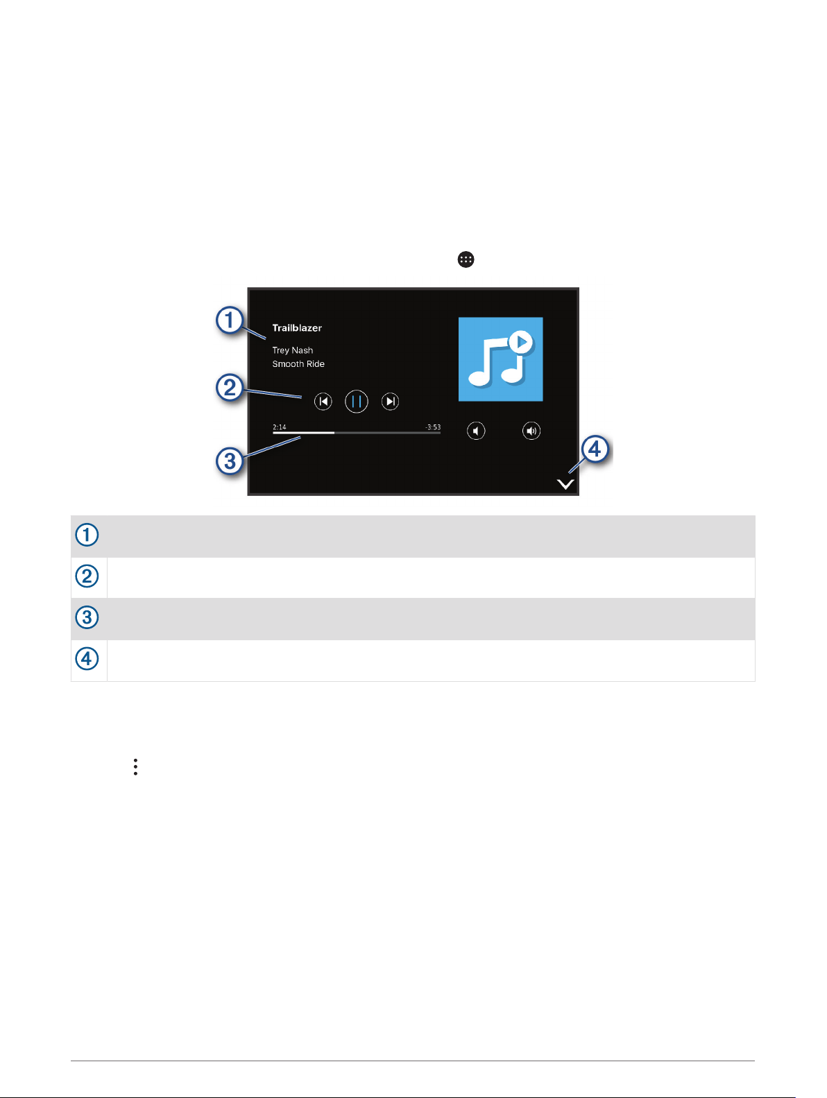
Viewing Weather Near a Different City
1 From the home screen, select the weather widget (Home Screen, page 7).
2 Select Current Location.
3 Select an option:
• To view weather for a favorite city, select a city in the list.
• To add a favorite city, select Add City, and enter a city name.
Media Player
The media player allows your device to control the media currently playing from a media app on your paired
phone. You can open the media player at any time by selecting > Tools > Media Player from the main menu.
Information about the currently playing media, such as title, artist, album, station, or channel.
Playback controls. The controls change based on the service providing the media.
Progress through the current media item.
Select to hide or shrink the media player.
Adding the Music Player Tool to the Map
The music player map tool enables you to control the music player from your map.
1 Open the map.
2 Select > Media Player.
The music player controls appear on the map.
Using the Apps 53

Settings
Navigation Settings
Select Settings > Navigation.
Calculation Mode: Sets the route calculation method.
Avoidances: Sets road features to avoid on a route.
Custom Avoidances: Allows you to avoid specific roads or areas.
Environmental Zones: Sets the avoidance preferences for areas with environmental or emissions restrictions
that may apply to your vehicle.
Toll Roads: Sets the preferences for avoiding toll roads.
Tolls and Fees: Sets the preferences for avoiding toll roads and toll stickers.
NOTE: This feature is not available in all areas.
Restricted Mode: Disables all functions that require significant operator attention.
Travel History: Allows the device to store a record of the places you go. This allows you to view the trip log, use
the Trip History feature, and use myTrends suggested routes.
Clear Travel History: Allows you to clear all travel history from the device.
Map and Vehicle Settings
Select Settings > Map and Vehicle.
Vehicle: Sets the vehicle icon that represents your position on the map.
Voice Language: Sets the language for navigation voice prompts.
Driving Map View: Sets the perspective on the map.
Map Detail: Sets the level of detail on the map. More detail may cause the map to draw slower.
Map Theme: Changes the color of the map data.
Map Layers: Sets the data that appears on the map page (Customizing the Map Layers, page 30).
Auto Zoom: Automatically selects the zoom level for optimal use of your map. When disabled, you must zoom
in or out manually.
myMaps: Sets which installed maps the device uses.
Enabling Maps
You can enable map products installed on your device.
TIP: To purchase additional map products, go to garmin.com/maps.
1 Select Settings > Map and Vehicle > myMaps.
2 Select a map.
Connecting to a Wireless Network
1 Select Settings > Wireless Networks > Wi-Fi.
2 If necessary, select the toggle switch to turn on wireless network technology.
3 Select a wireless network.
4 If necessary, enter the encryption key.
The device connects to the wireless network. The device remembers the network information and connects
automatically when you return to this location in the future.
Enabling Bluetooth Wireless Technology
Select Settings > Wireless Networks > Bluetooth.
54 Settings

Driver Assistance Settings
Select Settings > Driver Assistance.
Audible Driver Alerts: Enables an audible alert for each type of driver alert (Driver Awareness Features and
Alerts, page 11).
Proximity Alerts: Alerts you when you approach speed cameras or red light cameras.
Route Preview: Shows a preview of the major roads in your route when you start navigation.
Break Planning: Enables break planning features that monitor your driving time, suggest breaks, and show
upcoming services.
Traffic Settings
From the main menu, select Settings > Traffic.
Traffic: Enables the traffic feature.
Current Provider: Sets the traffic provider to use for traffic data. The Auto option selects the best available
traffic data automatically.
Subscriptions: Lists the current traffic subscriptions.
Optimize Route: Enables the device to use optimized alternate routes automatically or upon request (Avoiding
Traffic Delays on Your Route, page 17).
Traffic Alerts: Sets the traffic delay severity for which the device displays a traffic alert.
Display Settings
Select Settings > Device > Display.
Brightness Level: Sets the display brightness level on your device.
Adaptive Brightness: Automatically adjusts the backlight brightness based on the ambient light when the
device is out of the mount.
Theme: Allows you to select day or night color mode. If you select the Automatic option, the device
automatically switches to day or night colors based on the time of day.
Wallpaper: Sets the wallpaper background on your device.
Sleep: Allows you to set the amount of idle time before your device enters sleep mode while using battery
power.
Daydream: Enables or disables the daydream screen saver.
Font size: Increases or decreases the font size on your device.
When device is rotated: Enables the screen to rotate automatically between portrait and landscape display
modes based on the device orientation or remain in the current orientation.
Sound and Notification Settings
Select Settings > Device > Sound & Notification.
Volume Sliders: Set the volume levels for navigation, media, calls, alarms, and notification alerts.
Do not disturb: Sets the rules for the automatic do-not-disturb feature. This feature allows you to disable
audible alerts during specific times or events.
Default notification ringtone: Sets the default notification ringtone sound on your device.
Other sounds: Allows you to enable or disable sounds for other device interactions, such as screen touches,
screen locking, or charging.
Cast: Allows you to wirelessly send the device audio or video to a compatible speaker, display, or device.
When device is locked: Sets whether notifications appear on the screen while the device is locked.
App notifications: Allows you to enable or disable notifications for each installed app and modify the do not
disturb preferences for each app.
Notification access: Allows you to select which apps have access to read system and app notifications.
Do not disturb access: Allows you to select which apps can override or modify the do not disturb settings.
Settings 55

Adjusting Sound and Notification Volume
1 Select Settings > Device > Sound & Notification.
2 Use the slider bars to adjust the sound and notification volume.
Enabling or Disabling Location Services
The location services feature must be enabled for your device to find your location, calculate routes, and
provide navigational assistance. You can disable location services to plan a route when GPS signals are not
available. When location services are disabled, the device enables a GPS simulator to calculate and simulate
routes.
TIP: Disabling location services can help save battery power.
1 Select Settings > Personal > Location.
2 Select the toggle switch to enable or disable location services.
NOTE: For most uses, you should not change the Mode setting from the default option of Device only. The
device includes a high-performance GPS antenna that provides the most accurate location data while
navigating.
Setting the Text Language
You can select the language for text in the device software.
1 Select Settings > Personal > Language & Input > Language.
2 Select a language.
Date and Time Settings
Select Settings > System > Date & Time.
Automatic time zone: Automatically sets the time zone based on information from the connected network.
Select time zone: Sets the time zone on your device when Automatic time zone is disabled.
Use 24-hour format: Enables or disables the 24-hour time format.
Device Settings
Select Settings > About Device.
Status: Displays the system status and network information.
Legal Information: Allows you to view the end-user license agreement (EULA) and software license
information.
Regulatory information: Displays e-label regulatory and compliance information.
Garmin device information: Displays hardware and software version information.
Device Data Reporting: Shares anonymous data to improve the device.
Restoring Settings
You can restore a category of settings to the factory default values.
1 Select Settings.
2 Select a settings category.
3 Select > Restore.
Device Information
Viewing E-label Regulatory and Compliance Information
1 From the settings menu, swipe to the bottom of the menu.
2 Select About Device > Regulatory information.
56 Device Information

Specifications
Operating temperature range From -20° to 55°C (from -4° to 131°F)
Charging temperature range From 0° to 45°C (from 32° to 113°F)
Radio frequency (dēzl OTR800 /
LGV800)
2.4 GHz @ 14 dBm
Radio frequency (dēzl OTR1000 /
LGV1000)
2.4 GHz @ 15 dBm
Power input
Vehicle power using the included vehicle power cable. AC power
using an optional accessory (for home and office use only).
Battery type Rechargeable lithium-ion
Charging the Device
NOTE: This Class III product shall be powered by an LPS power supply.
You can charge the battery in the device using any of these methods.
• Install the device in the mount, and connect the mount to vehicle power.
• Connect the device to an optional power adapter accessory, such as a wall power adapter.
You can purchase an approved Garmin AC-DC adapter suitable for home or office use from a Garmin dealer
or www.garmin.com. The device may charge slowly when connected to a third-party adapter.
Device Maintenance
Garmin Support Center
Go to support.garmin.com for help and information, such as product manuals, frequently asked questions,
videos, and customer support.
Device Maintenance 57

Updating Maps and Software Using a Wi‑Fi Network
NOTICE
Map and software updates may require the device to download large files. Regular data limits or charges from
your internet service provider apply. Contact your internet service provider for more information about data
limits or charges.
You can update the maps and software by connecting your device to a Wi‑Fi network that provides access to
the internet. This allows you to keep your device up to date without connecting it to a computer.
1 Using the included USB cable, connect the device to external power.
NOTE: A USB power adapter is not included. Go to the product page on garmin.com to purchase a power
adapter accessory.
2 Connect the device to a Wi‑Fi network (Connecting to a Wireless Network, page 54).
While connected to a Wi‑Fi network, the device checks for available updates automatically and displays a
notification when an update is available.
3 Select an option:
• When an update notification appears, swipe down from the top of the screen, and select An update is
available..
• To manually check for updates, select Settings > Updates.
The device displays available map and software updates. When an update is available, Update Available
appears below Map or Software.
4 Select an option:
• To install all available updates, select Download.
• To install only map updates, select Map.
• To install only software updates, select Software.
5 If necessary, read the license agreements, and select Accept All to accept the agreements.
NOTE: If you do not agree with the license terms, you can select Reject. This stops the update process. You
cannot install updates until you accept the license agreements.
6 Keep the device connected to external power and within range of the Wi‑Fi network until the update process
is complete.
TIP: If a map update is interrupted or canceled before it completes, your device may be missing map data. To
repair missing map data, you must update the maps again.
58 Device Maintenance
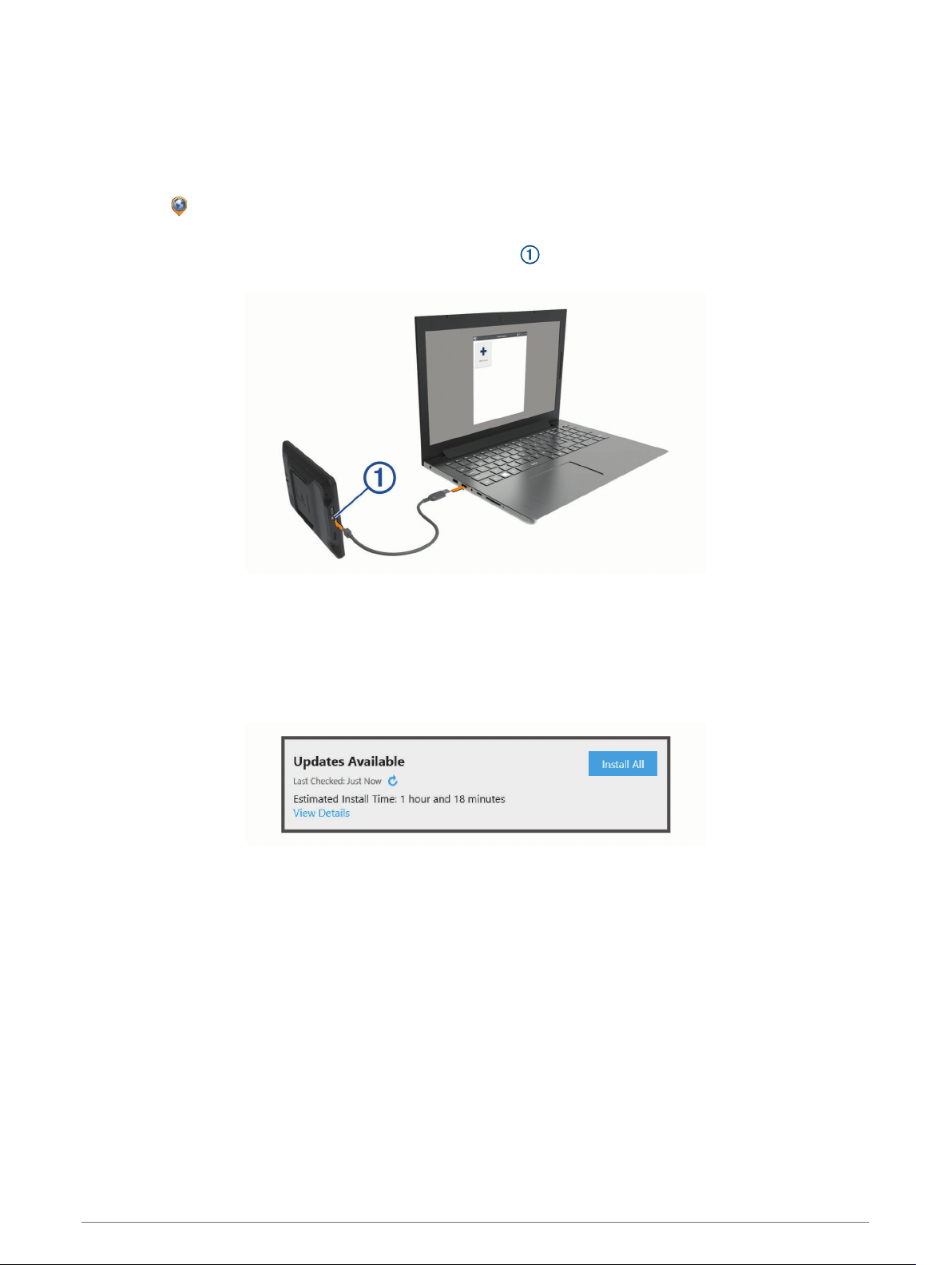
Updating Maps and Software with Garmin Express
You can use the Garmin Express application to download and install the latest map and software updates for
your device.
1 If you do not have the Garmin Express application installed on your computer, go to garmin.com/express
and follow the on-screen instructions to install it (Installing Garmin Express, page 60).
2 Open the Garmin Express application.
3 Connect your device to your computer using a micro-USB cable.
The small end of the cable connects to the micro-USB port on your dēzl device, and the large end
connects to an available USB port on your computer.
4 When your dēzl device prompts you to enter file transfer mode, select Yes.
5 In the Garmin Express application, click Add a Device.
The Garmin Express application searches for your device and displays the device name and serial number.
6 Click Add Device, and follow the on-screen instructions to add your device to the Garmin Express
application.
When setup is complete, the Garmin Express application displays the updates available for your device.
7 Select an option:
• To install all available updates, click Install All.
• To install a specific update, click View Details, and click Install next to the update you want.
The Garmin Express application downloads and installs the updates onto your device. Map updates are very
large, and this process may take a long time on slower internet connections.
NOTE: If a map update is too large for the internal storage of the device, the software may prompt you to
install a microSD
®
card in your device to add storage space (Installing a Memory Card for Maps and Data,
page 64).
8 Follow the on-screen instructions during the update process to finish installing updates.
For example, during the update process, the Garmin Express application may instruct you to disconnect and
reconnect your device.
Device Maintenance 59

Installing Garmin Express
The Garmin Express application is available for Windows
®
and Mac
®
computers.
1 On your computer, go to garmin.com/express.
2 Select an option:
• To view the system requirements and verify the Garmin Express application is compatible with your
computer, select System Requirements.
• To install on a Windows computer, select Download for Windows.
• To install on a Mac computer, select Download for Mac.
3 Open the downloaded file, and follow the on-screen instructions to complete the installation.
Device Care
NOTICE
Avoid dropping your device.
Do not store the device where prolonged exposure to extreme temperatures can occur, because it can cause
permanent damage.
Never use a hard or sharp object to operate the touchscreen, or damage may result.
Do not expose the device to water.
Cleaning the Outer Casing
NOTICE
Avoid chemical cleaners and solvents that can damage plastic components.
1 Clean the outer casing of the device (not the touchscreen) using a cloth dampened with a mild detergent
solution.
2 Wipe the device dry.
Cleaning the Touchscreen
1 Use a soft, clean, lint-free cloth.
2 If necessary, lightly dampen the cloth with water.
3 If using a dampened cloth, turn off the device and disconnect the device from power.
4 Gently wipe the screen with the cloth.
Avoiding Theft
• Remove the device and mount from sight when not in use.
• Remove the residue left on the windshield by the suction cup.
• Do not keep your unit in the glove compartment.
• Register your device using the Garmin Express software (garmin.com/express).
Resetting the Device
You can reset your device if it stops functioning.
Hold the power key for 12 seconds.
Removing the Device, Mount, and Suction Cup
Removing the Mount from the Suction Cup
1 Loosen the nut that secures the magnetic powered mount to the suction cup ball.
2 Turn the device mount to the right or left.
3 Apply pressure until the socket on the mount releases the ball on the suction cup.
60 Device Maintenance

Removing the Suction Cup from the Windshield
1 Flip the lever on the suction cup toward you.
2 Pull the tab on the suction cup toward you.
Troubleshooting
The suction cup will not stay on my windshield
1 Clean the suction cup and windshield with rubbing alcohol.
2 Dry with a clean, dry cloth.
3 Mount the suction cup (Mounting and Powering the Device in Your Vehicle, page 3).
The mount does not hold my device in place while I drive
For the best results, you should keep the vehicle mount clean and position the device close to the suction cup.
If the device shifts position while you are driving, you should complete these actions.
• Remove the powered mount from the suction cup arm, and wipe the ball and socket with a cloth.
Dust and other debris may reduce the friction in the ball and socket joint and allow the joint to shift while you
are driving.
• Rotate the hinged arm toward the suction cup as far as your windshield angle allows.
Positioning the device closer to the windshield reduces the effect of jarring and vibration from the road.
My device is not acquiring satellite signals
• Verify the location services feature is enabled (Enabling or Disabling Location Services, page 56).
• Take your device out of parking garages and away from tall buildings and trees.
• Remain stationary for several minutes.
The device does not charge in my vehicle
• Verify the vehicle is turned on and is supplying power to the power outlet.
• Verify the interior temperature of the vehicle is within the charging temperature range indicated in the
specifications.
• In the vehicle fuse box, verify the fuse for the vehicle power outlet is not broken.
My battery does not stay charged for very long
• Decrease the screen brightness (Display Settings, page 55).
• Shorten the display timeout (Display Settings, page 55).
• Decrease the volume (Adjusting Sound and Notification Volume, page 56).
• Turn off the wi-fi radio when it is not in use (Connecting to a Wireless Network, page 54).
• Put the device in power saving mode when not in use (Turning the Device On or Off, page 6).
• Keep your device away from extreme temperatures.
• Do not leave your device in direct sunlight.
Troubleshooting 61

My device does not connect to my phone
• Select Settings > Bluetooth.
The Bluetooth option must be enabled.
• Enable Bluetooth wireless technology on your phone and bring your phone within 10 m (33 ft.) of the device.
• Verify your phone is compatible.
Go to www.garmin.com/bluetooth for more information.
• Complete the pairing process again.
To repeat the pairing process, you must unpair your phone and device (Deleting a Paired Phone, page 34),
and complete the pairing process.
Appendix
Backup Cameras
Your device can display the video feed from one or more connected backup cameras.
Pairing a BC
™
35 Backup Camera with a Garmin Navigation Device
You must enable the Wi‑Fi setting on your Garmin navigation device before you can connect to a camera.
The BC 35 wireless backup camera is compatible with some Garmin navigation devices. Go to garmin.com
/bc35 for more information about device compatibility.
You can pair up to four BC 35 wireless backup cameras with your compatible Garmin navigation device.
1 Update your navigation device to the latest software.
Your device may not support the BC 35 camera without the latest software. For more information about
updating, see the owner's manual for your navigation device.
2 Turn on the Garmin navigation device, and bring it within 3 m (10 ft.) of the camera.
3 Select > Tools > Rear View.
4 Select an option:
• If this is the first camera you are connecting to the navigation device, select Add New Camera.
• If this is an additional camera you are connecting to the navigation device, select > Choose Camera >
Add New Camera.
5 Follow the on-screen instructions.
NOTE: The pairing code or password is located on the transmitter or the camera.
After you complete the pairing process with a camera for the first time, it connects automatically to the Garmin
navigation device.
Viewing the Backup Camera
Your device shows video from the connected backup camera in different ways, depending on how the camera
is connected to power.
1 Select an option to show video:
• If the camera is connected to a reverse lamp (recommended), place the vehicle into reverse.
The device automatically shows video from the backup camera.
• If the camera is connected to a steady power source, select > Tools > Rear View to manually view the
camera.
2 Select an option to resume normal device operation:
• If the camera is connected to a reverse lamp (recommended), take the vehicle out of reverse.
The device automatically resumes normal operation.
• If the transmitter is connected to a steady power source, select to manually hide the camera.
62 Appendix
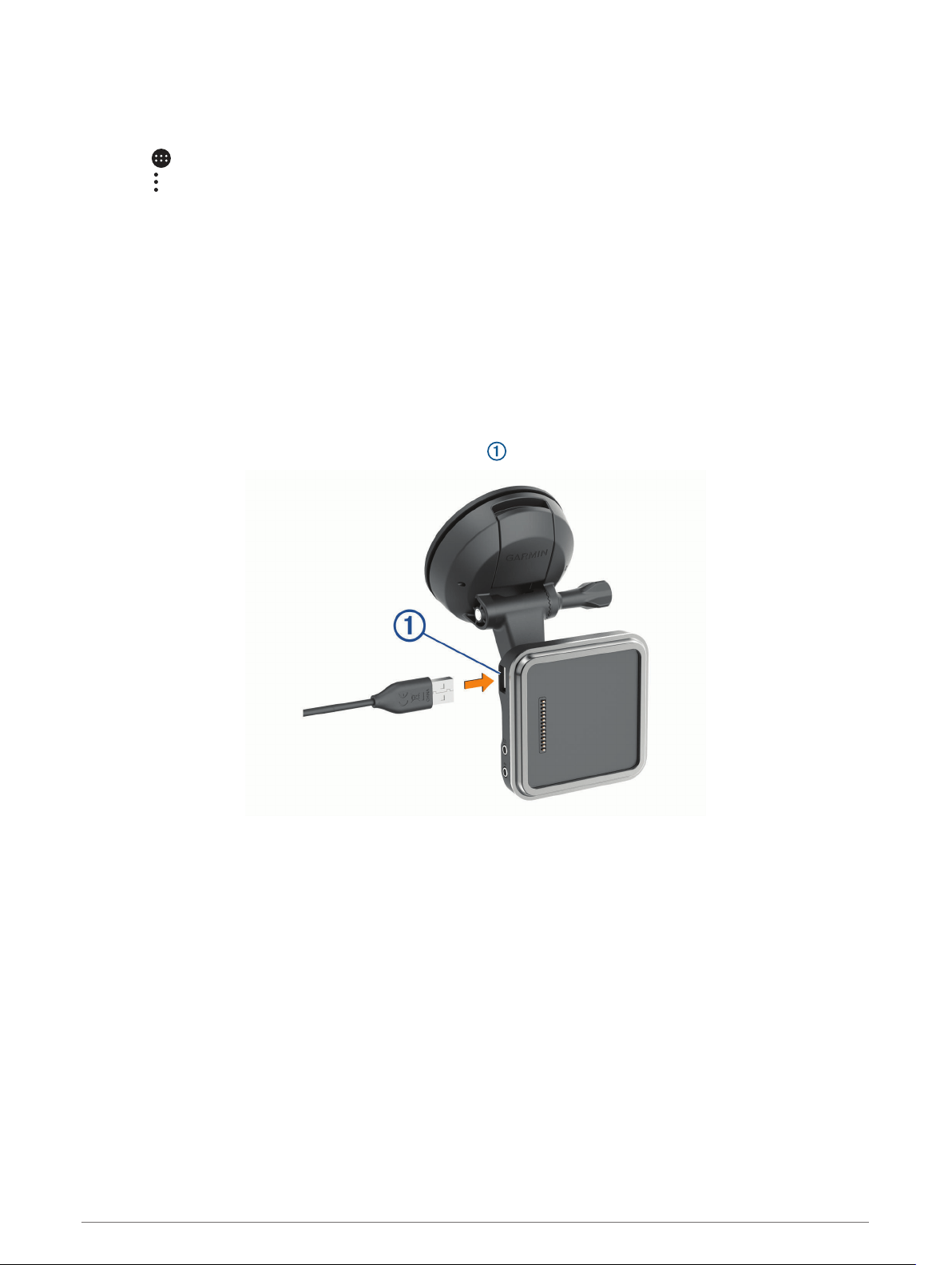
Switching Cameras
When multiple backup cameras are transmitting to your device, you can switch between the views from the
cameras.
1 Select > Tools > Rear View.
2 Select > Choose Camera.
3 Select a camera.
The video feed from the camera appears, and the camera name appears at the top of the screen.
Connecting a Dash Camera to the Powered Mount
Before you connect a dash camera to the powered mount, you should mount the dash camera device to your
windshield.
You can use the dēzl device mount to power a compatible Garmin dash camera. This can be useful if you need
to connect the dēzl device and the dash camera to the same power source in your vehicle.
1 Mount the dēzl device in your vehicle, and connect it to power (Mounting and Powering the Device in Your
Vehicle, page 3).
2 If necessary, remove the dēzl device from the magnetic mount for a better view of the USB port.
3 Plug the dash camera's power cable into the USB port on the mount.
Data Management
The device has a memory card slot for additional data storage.
NOTE: The device is compatible with Windows 7 and newer, and Mac OS 10.7 and newer.Apple computers may
require additional third-party software to read and write files.
About Memory Cards
You can purchase memory cards from an electronics supplier, or purchase pre-loaded Garmin mapping
software (www.garmin.com). Memory cards can be used to store files such as maps and custom POIs.
Appendix 63

Installing a Memory Card for Maps and Data
You can install a memory card to increase the storage space for maps and other data on your device. You can
purchase memory cards from an electronics supplier, or go to www.garmin.com/maps to purchase a memory
card with pre-loaded Garmin mapping software. The device supports microSD memory cards from 4 to 256 GB.
Memory cards must use the FAT32 file system format. Memory cards greater than 32 GB must be formatted
using the device (Formatting the Memory Card, page 64).
1 Locate the map and data memory card slot on your device (Device Overview, page 2).
2 Insert a memory card into the slot.
3 Press it in until it clicks.
Formatting the Memory Card
The device requires a memory card formatted using the FAT32 file system. You can use the device to format
your card using this file system.
You must format a brand new memory card if it is not formatted using the FAT32 file system.
NOTE: Formatting the memory card deletes all data on the card.
1 Select Settings > Device > Storage & USB.
2 Select your memory card.
3 Select > Settings > Format > ERASE & FORMAT.
4 Select Done.
Connecting the Device to Your Computer
You can connect the device to your computer using a USB cable.
1 Plug the small end of the USB cable into the port on the device.
2 Plug the larger end of the USB cable into a port on your computer.
3 When your dēzl device prompts you to enter file transfer mode, select Yes.
Depending on your computer operating system, the device appears as either a portable device, a removable
drive, or a removable volume.
Transferring Data From Your Computer
1 Connect the device to your computer (Connecting the Device to Your Computer, page 64).
Depending on your computer operating system, the device appears as either a portable device, a removable
drive, or a removable volume.
2 On your computer, open the file browser.
3 Select a file.
4 Select Edit > Copy.
5 Browse to a folder on the device.
NOTE: For a removable drive or volume, you should not place files in the Garmin folder.
6 Select Edit > Paste.
Purchasing Additional Maps
1 Go to your device product page at garmin.com.
2 Click the Maps tab.
3 Follow the on-screen instructions.
Purchasing Accessories
Go to garmin.com/accessories.
64 Appendix

Index
Symbols
2-D map view 30
3-D map view 30
A
accessories 64
active lane guidance 14
addresses, finding 20, 32
adverse conditions 43
alarm volume 56
alerts 11
audio 55
proximity points 55
answering calls 33
apps 8
audio, proximity points 55
avoidances 18
area 18
deleting 18
disabling 18
road 18
road features 17
tolls 17
B
backup camera 62, 63. See cameras
battery
charging 3, 57, 61
maximizing 61
problems 61
Bluetooth technology 31, 32, 62
deleting a paired device 34
disconnecting a device 34
enabling 54
pairing a phone 31
break planning 35, 36
brightness 9
C
calls 32, 33
answering 33
placing 50
camera
dash cam 63
pairing 62
cameras 63
backup 62
red light 12
speed 12
switching 63
changing the search area 21
charging the device 3, 57, 61
cleaning the device 60
cleaning the touchscreen 60
computer, connecting 63, 64
coordinates 23
current location 24
custom POIs 22
D
dash cam 63
data
backing up 40
restoring 40
deleting
paired Bluetooth device 34
service categories 38
service records 38
trips 51
destinations 52. See locations
arriving 14, 15
detours 16
device care 60
diagnostics 45–47
directions 14
disconnecting, Bluetooth device 34
display settings 55
driver alerts 11
drivers 42
adding 49
editing 49
driving directions 14
driving logs 43
duty status 43
E
editing, saved trips 52
emergency services 24
EULAs 56
exit services 27
exporting
jurisdiction summaries 37
trip reports 37
extras, custom points of interest 22
F
files, transferring 45, 64
finding locations. 19, 21, 24 See also
locations
addresses 20
categories 20
cities 27
coordinates 23
intersections 23
Foursquare 23
fuel, stations 24
fuel data 36, 37
G
Garmin Connect 31
Garmin Express 60
updating software 59
geocaching 23
going home 13
GPS 7
simulator 56
H
hands-free phone calls 33
headset, pairing 31
home
editing location 13
going 13
home screen 7
customizing 8
hours of service 39, 42, 43
driving logs 44, 45
duty status 44
inspection 44
I
icons, status bar 8
ID number 56
initial setup 39
International Fuel Tax Agreement (IFTA) 36
exported summaries and reports 37
fuel data 36, 37
jurisdiction summary 37
trip reports 37
intersections, finding 23
J
jurisdiction summary 37
L
language 56
latitude and longitude 23
location services 56
locations 20, 52
current 24, 25
recently found 24
saving 25
searching for 19, 22
simulated 56
M
malfunctions 45, 46, 48
map layers, customizing 30
map view
2-D 30
3-D 30
maps 12, 26, 29, 54
data field 13, 29, 30
detail level 54
layers 30
purchasing 64
symbols 13
theme 54
tools 26, 27
truck 51
updating 58, 59
viewing routes 13, 14
media player 53
media volume 56
memory card 2, 63
formatting 64
installing 64
microSD card 2, 64
mount, removing 60
mounting the device 6, 61
automobile 3
suction cup 3, 61
music, playing 53
myTrends, routes 17
N
navigation 13, 14, 50
settings 54
next turn 13
notification volume 56
notifications 8, 32–34
O
operation guidelines 40
owner's manual 50
P
pairing 31
deleting a paired device 34
disconnecting 34
headset 31
phone 31, 62
parking 15, 21, 22
phone
disconnecting 34
pairing 31, 62
phone calls 32, 33
answering 33
dialing 33
muting 33
photoLive 35
playing, music 53
POI Loader 22
points of interest (POI) 19, 23, 24
custom 22
extras 22
POI Loader 22
trucking 19
power cables 57
vehicle 3
power key 2, 6
product support 50
profiles
activating 9
truck 9, 10
Q
Quick Search 20
Index 65

R
recently found locations 24
red light cameras 12
removing mount 60
reports, trip 37
resetting
device 60
trip data 29
restoring settings 56
restrictions, vehicle 9
routes 12
adding a point 16, 52
calculating 16
calculation mode 52
myTrends 17
shaping 16
starting 12, 21
stopping 16
suggested 17
viewing on the map 13, 14
S
satellite signals, acquiring 7, 56
saved locations 52
categories 25
deleting 26
editing 25
saving, current location 25
screen, brightness 9
search bar 20
service history
categories 38
deleting 38
editing 38
records 38
settings 54–56
shaping a route 16
shortcuts
adding 8, 24
deleting 25
simulated locations 56
sleep mode 6
smartphone features 33
connecting 31
software
updating 58, 59
version 56
sound 56
speaking commands 50
specifications 57
speech recognition 50
speed cameras 12
starting a drive 40, 41
status, duty 43
suction cup 61
T
theft, avoiding 60
time settings 56
timer 36
tolls, avoiding 17
tools, maps 26, 27
touchscreen 8
traffic 30, 34, 55
alternate route 17
cameras 35
incidents 30, 35
map 30, 34
searching for delays 30, 35
traffic cameras, viewing 35
travel history 56
trip information 29
resetting 29
trip log, viewing 29
trip planner 51, 52
editing a trip 51
shaping points 52
Tripadvisor 23, 24
troubleshooting 61, 62
truck
drivers 49
map 51
points of interest 19
profiles 9, 10, 49
shipments 44
trailer 10, 44
turn list 14
U
unit ID 56
up ahead 27, 39
customizing 27
updating
maps 58, 59
software 58, 59
USB
hours of service, driving logs 45
transferring files 45
V
vehicle power cable 3
vehicle profile
car 9
truck 9, 10
viewing on the map 14
voice command 50
activating 50
tips 50
voice prompt 33
volume 56
adjusting 50
W
warning icons 28, 29
weather 52
Where Am I? 24, 25
Wi-Fi, connecting 54
Wi‑Fi 58
wireless camera. See cameras
wireless headset 33
66 Index


support.garmin.com
GUID-104136B1-8D89-47E2-8799-55395E18A7C3 v6August 2021