Loading ...
Loading ...
Loading ...

Red Light and Speed Cameras
NOTICE
Garmin is not responsible for the accuracy of or the consequences of using a red light or speed camera
database.
NOTE: This feature is not available for all regions or product models.
Information about red light and speed camera locations is available in some areas for some product models.
The device alerts you when you approach a reported speed or red light camera.
• In some areas, your device can receive live red light and speed camera data while connected to a
smartphone running the Garmin Drive app.
• You can use the Garmin Express
™
software (garmin.com/express) to update the camera database stored on
your device. You should update your device frequently to receive the most up-to-date camera information.
Navigating to Your Destination
Routes
A route is a path from your current location to one or more destinations.
• The device calculates a recommended route to your destination based on the preferences you set, including
the route calculation mode (Changing the Route Calculation Mode, page 16) and avoidances (Avoiding
Delays, Tolls, and Areas, page 17).
• The device can automatically avoid roads that are not appropriate for the active vehicle profile.
• You can start navigating to your destination quickly using the recommended route, or you can select an
alternate route (Starting a Route, page 12).
• If there are specific roads you need to use or avoid, you can customize the route (Shaping Your Route,
page 16).
• You can add multiple destinations to a route (Adding a Location to Your Route, page 16).
Starting a Route
1 Select Where To?, and search for a location (Finding and Saving Locations, page 19).
2 Select a location.
3 Select an option:
• To start navigating using the recommended route, select Go!.
• To choose an alternate route, select , and select a route.
Alternate routes appear to the right of the map.
• To edit the course of the route, select > Edit Route, and add shaping points to the route (Shaping Your
Route, page 16).
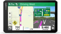
The device calculates a route to the location and guides you using voice prompts and information on the map
(Your Route on the Map, page 13). A preview of the major roads in your route appears at the edge of the map
for several seconds.
If you need to stop at additional destinations, you can add the locations to your route (Adding a Location to Your
Route, page 16).
Starting a Route by Using the Map
You can start route by selecting a location from the map.
1 Select View Map.
2 Drag and zoom the map to display the area to search.
3 Select a point, such as a street, intersection, or address location.
4 Select Go!.
12 Navigating to Your Destination
Loading ...
Loading ...
Loading ...