
IDS Geo
MNG/2024/006 Rev. 1.1 July 2026 User Manual
ORIGINAL INSTRUCTION IN ENGLISH LANGUAGE
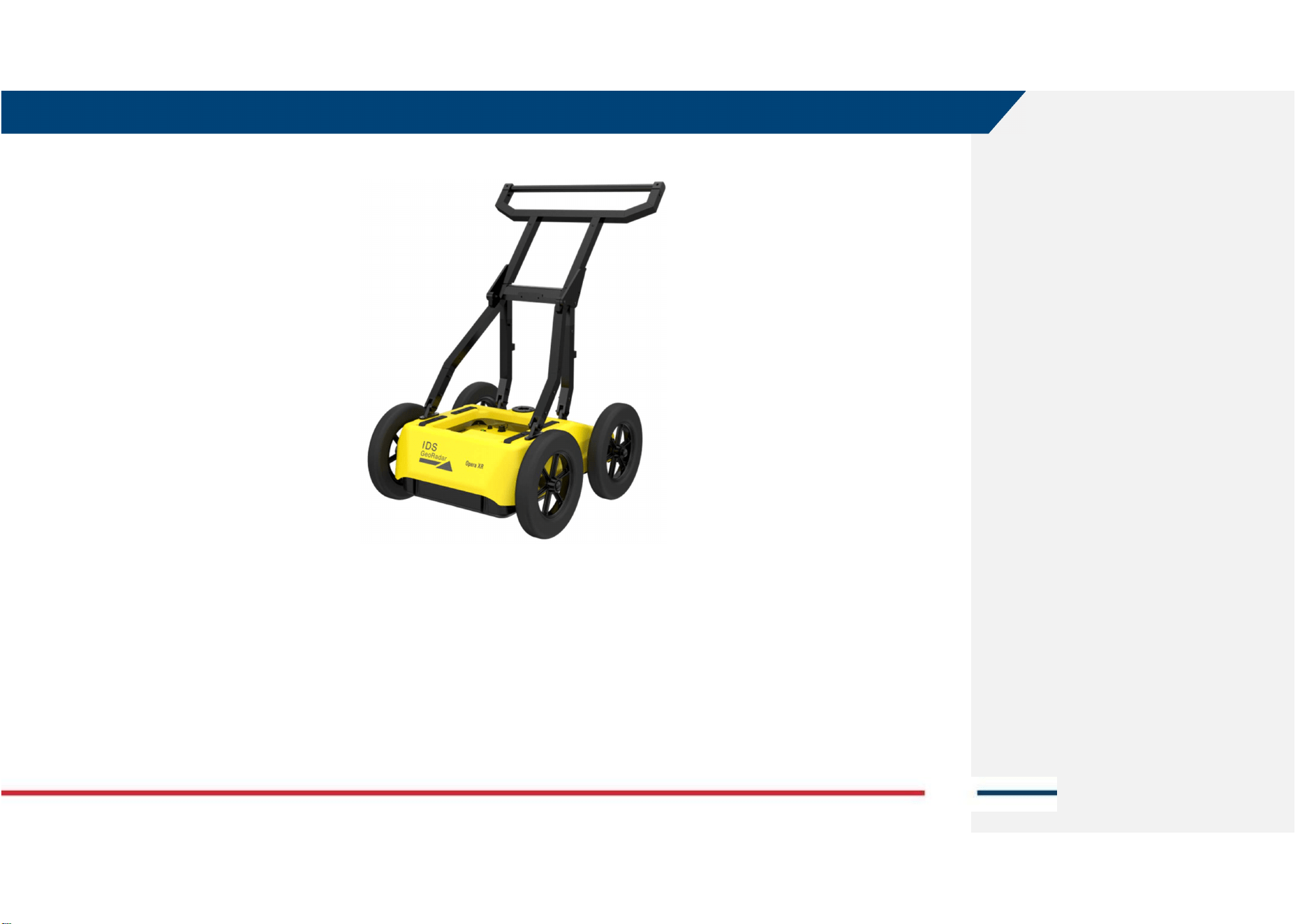
Opera XR
(Antenna type AE4H or AE4H2)
User Manual
Opera XR – User Manual Mod: MDM/011/M2 Rev11
IDS GeoRadar Srl MNG/2024/006 Rev. 1.1 2/ 44

IDS GeoRadar Srl MNG/2024/006 Rev. 1.1 3/ 44
LEGAL NOTICE
Use of the Manual
This Manual is intended to be used solely by authorized user of IDS GeoRadar Systems. It is specific for internal business purpose only. If you are not an authorized user, you are NOT allowed to
read this Manual and you must return it to IDS GeoRadar as soon as possible. Access to and use of this Manual is also provided subject to the acceptance of the Disclaimer set out below.
Disclaimer
About the Manual
This Manual has been drafted by IDS GeoRadar with the due care in order to ensure the accuracy and completeness. However, please note that no warranty is provided about the fact that the
Manual will be free from error or omission and about the accuracy and/or fitness to the purpose of any information contained herein.
Any representation and/or statement contained herein has been written in good faith and on the basis that, due to negligence, lack of care or otherwise, IDS GeoRadar is not liable for any loss,
including direct, indirect or consequential losses, in contract or in tort for any misstatement or omission contained herein which has occurred or may occur with reference to any representation
and/or statement contained in the Manual.
User shall also acknowledge that some information contained in the Manual may not be up to date. IDS GeoRadar may amend the information contained in the Manual from time to time and IDS
GeoRadar shall not be deemed liable in the event that damages arise with reference to changed circumstances or other information which may affect the accuracy of any information contained in
this version of the Manual.
About the Product
All products designed, produced and distributed by IDS GeoRadar, its Subsidiaries, Affiliated and authorized Distributors (Products) shall not be used, in the design, development, production or use
of chemical, biological, nuclear ballistic weapons. Buyer/ User will defend, indemnify and hold IDS GeoRadar harmless against any liability (including attorney’s fees) for non-compliance with the
terms of this paragraph.
If IDS GeoRadar requires that Buyer/User shall carry out a training with reference to some Product categories, no operation or use of the Products shall be started before its designated Operator/s
has got the User Certificate, as defined by IDS GeoRadar specific procedure which the Buyer confirms to know and accept.
For Products which include specific “Operational” software with automatic data processing and analysis “Tools”, e.g. RockSpot, IBIS Products; Hydra Products, User shall be aware that the results
provided by these “Tools” may be not error free. User that completely relies on the outcomes provided by these Tools only, does it at his own risk.
In no event IDS GeoRadar shall be liable for special, direct, indirect, incidental, exemplary, punitive or consequential damages including, but not limited to, loss of profits or revenue, caused by the
missed or incomplete observance of the instructions and prescriptions for the use of the Products, either separately or in combination with other products.
This paragraph provides only a non-exhaustive summary of the full Product disclaimer. Please see the full Product disclaimer included into the relevant section of this Manual for detailed information.
Confidentiality
This Manual may be subject to legal and other privilege. IDS GeoRadar specifically reserves its rights in relation to this Manual. None of these rights or any other rights subsisting in the Manual are
waived if you have received this Manual in error or without permission. No parts of this Manual may be copied, translated or reduced to any electronic medium, or machine-readable form, nor
photographed or recorded in any way, without the prior written consent of IDS GeoRadar.

INDEX
Mod: MDM/011/M2 Rev10
IDS GeoRadar Srl MNG/2024/006 Rev. 1.1 4/ 44
INDEX
1
INTRODUCTION .......................................................................................................................................................................................................................................... 6
1.1
ESTIMATED READING TIME .................................................................................................................................................................................................................................. 6
1.2
PURPOSE .......................................................................................................................................................................................................................................................... 6
1.3
APPLICATION FIELD ............................................................................................................................................................................................................................................. 6
1.4
INTENDED READERSHIP ........................................................................................................................................................................................................................................ 6
1.5
AUTHORIZATION OF USE ...................................................................................................................................................................................................................................... 7
1.5.1
CE Compliance ...................................................................................................................................................................................................................................... 7
1.5.2
UKCA Compliance ................................................................................................................................................................................................................................. 7
1.5.3
FCC Compliance .................................................................................................................................................................................................................................... 7
2
HOW TO READ THE MANUAL ..................................................................................................................................................................................................................... 8
2.1
MANUAL LAYOUT ............................................................................................................................................................................................................................................... 8
2.2
SYMBOLS ....................................................................................................................................................................................................................................................... 8
2.3
GLOSSARY & ACRONYMS ..................................................................................................................................................................................................................................... 9
3
SAFETY DIRECTIONS ..................................................................................................................................................................................................................................10
3.1
DESCRIPTION ................................................................................................................................................................................................................................................... 10
3.2
INTENDED USE ................................................................................................................................................................................................................................................. 10
3.3
REASONABLY FORESEEABLE MISUSE ..................................................................................................................................................................................................................... 10
3.4
LIMITS OF USE ................................................................................................................................................................................................................................................. 10
3.5
RESPONSIBILITIES ............................................................................................................................................................................................................................................. 10
3.6
HAZARD OF USE ............................................................................................................................................................................................................................................... 11
4
GENERAL DESCRIPTION .............................................................................................................................................................................................................................14
4.1
DELIVERY CONTENT .......................................................................................................................................................................................................................................... 14
4.1.1
Opera XR (SAP1023280) ..................................................................................................................................................................................................................... 14
4.1.2
Opera XR GNSS support Kit (SAP 1020729) ........................................................................................................................................................................................ 15
4.1.3
Opera XR Off-Road Wheels kit (SAP 1020726) ................................................................................................................................................................................... 15
4.1.4
Opera XR Shipping Box (SAP 1026386) ............................................................................................................................................................................................... 16
5
HOW TO SET UP OPERA XR AND ACCESSORIES ..........................................................................................................................................................................................17
5.1
HOW TO SET UP OPERA XR ................................................................................................................................................................................................................................ 17
5.2
HOW TO SET UP GNSS SUPPORT KIT .................................................................................................................................................................................................................... 20
5.3
HOW TO SET UP OFF ROAD WHEELS KIT ................................................................................................................................................................................................................ 23

INDEX
Mod: MDM/011/M2 Rev10
IDS GeoRadar Srl MNG/2024/006 Rev. 1.1 5/ 44
5.4
HOW TO STORE OPERA XR INTO THE SHIPPING BOX ................................................................................................................................................................................................ 23
6
HOW TO WORK ON SITE WITH OPERA XR .................................................................................................................................................................................................26
6.1
HOW TO SET UP OPERA XR IN HH OR VV POLARIZATION ......................................................................................................................................................................................... 26
6.2
HOW TO CONNECT THE FIELD PC AND THE OPERA XR ANTENNA ................................................................................................................................................................................ 27
6.3
HOW TO COLLECT OPERA XR DATA IN QUICK SCAN MODE ........................................................................................................................................................................................ 29
6.4
HOW TO COLLECT OPERA XR DATA IN GRID MODE ................................................................................................................................................................................................ 30
6.5
HOW TO COLLECT OPERA XR DATA IN GNSS MODE ................................................................................................................................................................................................ 31
6.6
HOW TO COLLECT OPERA XR DATA IN TPS MODE ................................................................................................................................................................................................... 31
7
CARE AND TRANSPORT .............................................................................................................................................................................................................................33
7.1
CLEANING INFORMATION ................................................................................................................................................................................................................................... 33
7.2
BATTERY REMOVAL INFORMATION ...................................................................................................................................................................................................................... 33
7.3
PERIODICAL CHECK ........................................................................................................................................................................................................................................... 34
7.4
PROPER SYSTEM USE ......................................................................................................................................................................................................................................... 34
8.1
MYWORLD ...................................................................................................................................................................................................................................................... 35
8.2
HOW TO MANAGE RETURN FOR SERVICE ............................................................................................................................................................................................................... 35
APPENDIX A
DISCLAIMER .........................................................................................................................................................................................................................37
APPENDIX B
TECHNICAL SPECIFICATIONS .................................................................................................................................................................................................39
APPENDIX C
CONFORMITY TO EUROPEAN AND UK REGULATIONS ...........................................................................................................................................................40
APPENDIX D
IMPORTANT NOTE FOR US CUSTOMERS ...............................................................................................................................................................................41
APPENDIX E
IMPORTANT NOTES FOR CANADIAN CUSTOMERS ................................................................................................................................................................43
APPENDIX F
CONTACTS ............................................................................................................................................................................................................................44

1 INTRODUCTION
Mod: MDM/011/M2 Rev 10
IDS GeoRadar Srl MNG/2024/006 Rev. 1.1 6/ 44
1 INTRODUCTION
This document describes Opera XR system, that is a dual frequency GPR
system by IDS GeoRadar.
This document refers to the concepts the User must learn before initiating
the utilization of this device. Therefore, it is mandatory to carefully read the
entire document before starting and operating the system.
1.1 Estimated Reading Time
The estimated reading time of the entire document is 90 minutes.
1.2 Purpose
The purpose of this document is to drive the Reader to a list of actions to
install and use the Opera XR system, in a thorough, correct, and safe way.
The structure of the manual is organized in a collection of "how-to" as well
as descriptive chapters. Each chapter contains illustrations and basic
descriptions of the main operations to be carried out for system installation
and use on field.
1.3 Application field
The main application of Opera XR is the collection of GPR data over areas of
variable extension, and for applications including, but not limited to, utility
mapping, environmental, archaeology, geology, geotechnic. Also, any type of
buried objects or structures may be the aim of the system if these are buried
within Opera XR depth of reach.
1.4 Intended readership
The intended Reader(s) of this manual is the technician(s) in charge of using
the system that has undergone the IDS GeoRadar training for Opera XR.
Training to Users, may also be delivered by either IDS GeoRadar local Selling
Units or Distributor Partners.
1 INTRODUCTION
Mod: MDM/011/M2 Rev 10
IDS GeoRadar Srl MNG/2024/006 Rev. 1.1 7/ 44
1.5 Authorization of use
The use of Opera XR system may be subject to a license and/or an
authorization by the Competent Ministry of the country where the system
will be used. An individual license and restrictions are in place to date in the
following European countries:
France: https://www.anfr.fr/en/broadcasting-authorisation/reseaux-
professionnels/les-frequences-utilisees-a-titre-temporaire/les-systemes-
dimagerie-radar-de-type-gpr-wpr/
Germany:
https://www.bundesnetzagentur.de/SharedDocs/Downloads/DE/Sachgebie
te/Telekommunikation/Unternehmen_Institutionen/Technik/Inverkehrbrin
genvonProdukten/Schnittstellenbeschreibungen/OrtungsfunkOR/SSBOR_N
N022.pdf?__blob=publicationFile&v=4
Portugal:
https://www.anacom.pt/render.jsp?categoryId=389647
Romania: https://www.ancom.ro/radio-spectrum_2749
Spain: https://www.boe.es/diario_boe/txt.php?id=BOE-A-
2011-19146
Sweden:
https://www.pts.se/sv/bransch/radio/radiotillstand/ansokningshandlingar/
Liechtenstein and Switzerland:
https://www.bakom.admin.ch/bakom/en/homepage/frequencies-and-
antennas/frequency-use-with-or-without-licences/radiocommunication-
licences-in-general.html
For more details with reference to the restriction, please refer to the
following website: ECO Frequency Information System (cept.org)
CH DE
ES FR
LI PT
RO SE
1.5.1 CE Compliance
This equipment complies with the essential requirements
and other relevant provisions of:
Directive 2014/53/UE
Directive 2011/65/UE + 2015/863/UE RoHS
Regulation (EC) No 1907/2006 REACH
The full Declaration of its Conformity can be found either on
the CD or a separate document included with this product.
This is a Class A product. In a domestic environment it may
cause radio interference. If so, the user may need to take
adequate measures.
1.5.2 UKCA Compliance
This equipment complies with the essential requirements of the
Radio Equipment Regulations 2017 (S.I. 2017/1206). The full
Declaration of its Conformity can be found either on the CD or a
separate document included with this product.
Licensing requirements in UK can be found here:
https://www.ofcom.org.uk/manage-your-
licence/radiocommunication-licences/licensed-short-range
1.5.3 FCC Compliance
This device complies with part 15F of the FCC Rules. Operation is subject to
the following two conditions:
1. This device may not cause harmful interference, and
2. This device must accept any interference received, including
interference that may cause undesired operation.
2 HOW TO READ THE MANUAL
Mod: MDM/011/M2 Rev 10
IDS GeoRadar Srl MNG/2024/006 Rev. 1.1 8/ 44
2 HOW TO READ THE MANUAL
2.1 Manual Layout
As mentioned, this User Manual is structured in a “How to” manner. In each
of the relevant chapters, User shall find the basics to carry out the Opera XR
installation and use.
It is strongly recommended to go through this manual thoroughly, and to
read it carefully. However, as the document is divided into a first part that is
descriptive of the whole system, but also into procedures that are self-
consistent and that can be read sparsely, it is not mandatory to read this
document chapter after chapter, in case of need.
Please, note that images and pictures shown in the manual aims at
supporting the Users in understanding the operation described. However,
pictures and images portraited herein may, from time to time, slightly differ
from the actual Hardware and Software they describe.
2.2 SYMBOLS
Warning messages are an essential part of the Safety Concept of the
instrument. They appear wherever hazards or hazardous situations can
occur.
Warning messages:
• make the user alert about direct and indirect hazards concerning
the use of the product, and
• contain general rules of behaviour.
For the user’s safety, all safety instructions and safety messages shall be
strictly observed and followed. Therefore, the manual must always be
available to all persons performing any tasks described herein.
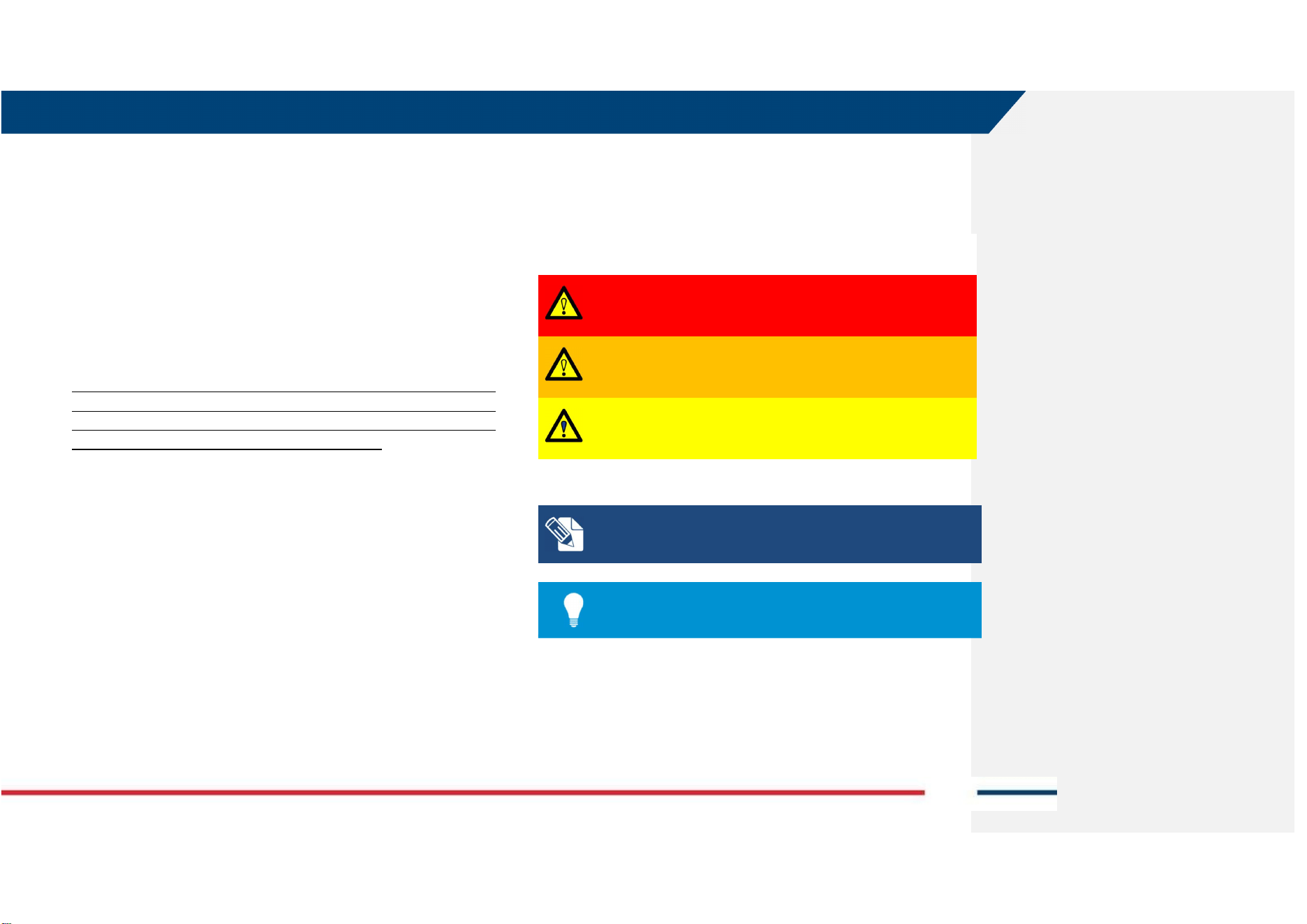
DANGER, WARNING, CAUTION and NOTICE has got standardized signal
words for identifying levels of hazards and risks related to personal injury and
property damage.
For safety purposes, it is important to read and fully understand the table
below with the different signal words and their definitions. Supplementary
safety information symbols may be placed within a warning message as well
as supplementary text.
Type Description
DANGER
Indicates an imminently hazardous situation which,
if not avoided, will result in death or serious injury.
WARNING
Indicates a potentially hazardous situation or an
unintended use which, if not avoided, could result
in death or serious injury.
CAUTION
Indicates a potentially hazardous situation or an
unintended use which, if not avoided, may result in
minor or moderate injury.
Note text/to keep in mind
Tip information

2 HOW TO READ THE MANUAL
Mod: MDM/011/M2 Rev 10
IDS GeoRadar Srl MNG/2024/006 Rev. 1.1 9/ 44
2.3 Glossary & Acronyms
The following acronyms are used in this manual:
- Opera XR: IDS GeoRadar GPR System
- Controller: PC / Tablet used by the user for data acquisition. The data
acquisition SW (client) is performed on the controller.
- GNSS: Global Navigation Satellite System.
- GPR: Ground Penetrating Radar or Georadar or Ground Probing
Radar.
- HMI: Human Machine Interface.
- HW: Hardware.
- NMEA format: National Marine Electronics Association format.
- RTK: Real Time Kinematic.
- SNR: Signal to Noise Ratio.
- SW: Software.
- UBLOX: GNSS device within the GPR system.
- uMap-Logger: IDS GeoRadar software for GPR data acquisition.
- SAP (follow by 6-digit): ID code to identify the part number.
3 SAFETY DIRECTIONS
Mod: MDM/011/M2 Rev 10
IDS GeoRadar Srl MNG/2024/006 Rev. 1.1 10/ 44
3 SAFETY DIRECTIONS
3.1 Description
The following directions enable the person responsible for the product, and
the person who uses the equipment, to anticipate and avoid operational
hazards.
The person responsible for the product must ensure that all users understand
these directions and adhere to them.
3.2 Intended use
The intended use of Opera XR is the detection of underground features in
diverse environmental conditions, and within the depth of reach of the
system itself, including but not limited to:
• Utility mapping
• Geotechnical
• Environmental
• Glaciers
• Rivers
• Archaeology
• Forensic
• Buried structures, in general.
NOTE: The product is intended for professional use only; not
for consumers use.
3.3 Reasonably Foreseeable Misuse
Infringing traffic regulation.
Use of the product without instruction.
Use outside of the intended use and limits.
Opening the product using tools, for example screwdriver, unless this
is permitted for certain functions.
Modification or conversion of the product.
Use after misappropriation.
Use of products with obvious damages or defects.
Use with accessories from other manufacturers without the prior
explicit approval of IDS GeoRadar s.r.l.
Inadequate safeguards at the working site.
3.4 Limits of Use
Environment: Suitable for use in an atmosphere appropriate for permanent
human habitation. Not suitable for use in explosive environments.
WARNING: POTENTIALLY HAZARDOUS AREAS
working in hazardous areas, such as potentially explosive areas, or
close to electrical installations, or similar situations, could result
in death or serious injury.
PRECAUTION: Local safety authorities and safety experts must be
contacted, by the person in charge of the product, prior
commencing any survey in potentially hazardous areas for the due
risk assessment.
3.5 Responsibilities
Manufacturer of the product - IDS GeoRadar s.r.l. is responsible for supplying
the product, including the user manual and original accessories, in a safe
condition.
Person responsible for the product - The person responsible for the product
(the User) has the following duties:
• To understand the safety instructions on the product and the
instructions in the user manual, and the Quick Guides, provided
separately.
• To ensure that it is used in accordance with the instructions.
3 SAFETY DIRECTIONS
Mod: MDM/011/M2 Rev 10
IDS GeoRadar Srl MNG/2024/006 Rev. 1.1 11/ 44
• To be familiar with traffic laws and local regulations relating to
safety and accident prevention.
• To inform IDS GeoRadar s.r.l. immediately if the product and the
application becomes unsafe.
• To ensure that the traffic laws, the national laws, regulations,
and conditions for the operation of electromagnetics
transmitters are respected.
3.6 Hazard of Use
WARNING: CRUSHING HANDS, FINGERS AND TOES
While installing and using the system, the risk of fingers
pinching out may occur.
PRECAUTION: To mount and use the system, the user must
always wear protective gloves and safety boots.
WARNING: RISK OF ACCIDENTS
During surveys there is a danger of accidents occurring if the
user does not pay attention to the surrounding site
conditions, such as obstacles, excavations, or traffic.
PRECAUTIONS: During operations, the user of the product
must be fully aware of the existing site conditions, and
potential dangers.
WARNING: ELECTROCUTION
Because of the risk of electrocution, it is dangerous to use
poles and extensions near electrical installations such as
power cables or electrical railways.
PRECAUTIONS: Keep at a safe distance from electrical
installations. If it is essential to work in this environment, first
contact the safety authorities responsible for the electrical
installations and follow their safety instructions.
NOTICE: Watch out for erroneous measurement results if the
product has been dropped, misused, modified, or stored for
long periods.
Precautions:
Periodically carry out test measurements.
3 SAFETY DIRECTIONS
Mod: MDM/011/M2 Rev 10
IDS GeoRadar Srl MNG/2024/006 Rev. 1.1 12/ 44
WARNING: LIGHTING STRICKING
If the product is used with accessories (for example GNSS
pole support), the user may increase the risk of being struck
by lightning.
PRECAUTIONS: Do not use the product during thunderstorm.
NOTICE
:
If the accessories used with the product are not
properly secured and the product is subjected to mechanical
shock, for example blows or falling, the product may be
damaged.
Precautions:
When setting-up the product, make sure that the accessories
are correctly adapted, fitted, secured, and locked in position.
Avoid subjecting the product to mechanical stress.
NOTICE: If the product is improperly disposed, the following can
happen:
• If polymer parts are burnt, poisonous gases are produced
which may impair health.
• If batteries are damaged or are heated strongly, they can
explode and cause poisoning, burning, corrosion or
environmental contamination.
• By disposing of the product irresponsibly you may enable
unauthorized persons to use it in contravention of the
regulations, exposing themselves and third parties to the risk of
severe injury and rendering the environment liable to
contamination.
RECYCLING
The crossed out wheeled bin symbol shown on the equipment
indicates that the product must be recycled separately from
other waste at the end of its useful life.
Separate waste disposal of this product at the end of its useful
life will be organised and managed by IDS GeoRadar. When you
decide to dispose of the equipment, contact IDS GeoRadar and
follow the system that IDS GeoRadar has set up to permit the
separate collection of the apparatus at its life end.
Adequate separate collection for its subsequent recycling,
treatment and environmentally friendly disposal contributes
towards avoiding any unnecessary effects on the environment
and to health and favour the reuse or recycling of the materials
that make up the equipment. Unauthorised disposal of this
product as unsorted waste by its possessor will lead to an
administrative penalty foreseen by national regulations.
3 SAFETY DIRECTIONS
Mod: MDM/011/M2 Rev 10
IDS GeoRadar Srl MNG/2024/006 Rev. 1.1 13/ 44
WARNING: EXPOSURE OF BATTERIES TO HIGH MECHANICAL
STRESS, HIGH AMBIENT TEMPERATURE OR IMMERSION
INTO FLUIDS
High mechanical stress, high ambient temperatures or
immersion into fluids can cause leakage, fire, or explosions of
the batteries.
PRECAUTIONS: Protect the batteries from mechanical
influences and high ambient temperatures. Do not drop or
immerse batteries into fluids.
WARNING
:
MECHANICAL INFLUENCES
ON
BATTERIES
During the transport, shipping, or disposal of batteries it is
possible, for inappropriate mechanical influences, to
constitute a fire hazard.
PRECAUTIONS: Before shipping the product or disposing of it,
discharge the batteries by running the product until they are
flat. When transporting or shipping batteries, the person in
charge of the product must ensure that the applicable
national and international rules and regulations are observed.
Before transportation or shipping, please contact your local
passenger or freight transport company.
NOTICE: Only IDS GeoRadar authorized technical service are
entitled to repair this product.
WARNING: Short circuit of battery terminals
Risk of fire, electric shock, and damage.
PRECAUTIONS: Keep away any metallic or wet objects from
the battery terminals inside battery housing.
WARNING: Short circuit of battery terminals
If battery terminals are short-circuited e.g., by coming in
contact with jewellery, keys, metallised paper or other
metals, the battery can overheat and cause injury or fire, for
example by storing or transporting in pockets.
PRECAUTIONS: Make sure that the battery terminals do not
come into contact with metallic objects.
WARNING
:
Battery may get hot after prolonged use.
Risk of burning injuries.
PRECAUTIONS: Avoid touching the hot battery. Allow the
battery to cool down before removing it.
WARNING: SECURING OF THE WORKING SITE
Inadequate securing of the working site can lead to
dangerous situations, for example in traffic, on building sites,
and at industrial installations.
PRECAUTIONS: Always ensure that the working site is
adequately secured. Adhere to the regulations governing
safety, accident prevention, and road traffic.
4 GENERAL DESCRIPTION
Mod: MDM/011/M2 Rev 10
IDS GeoRadar Srl MNG/2024/006 Rev. 1.1 14/ 44
4 GENERAL DESCRIPTION
The Opera XR GPR system by IDS GeoRadar srl, is designed to detect and
locate underground features for a wide range of possible applications
including, but not limited to utility mapping, geology, geotechnical,
environmental, glaciers, rivers, archaeology, forensic, buried structures in
general. It provides georeferenced underground maps if a supported
positioning system is used and correctly paired to Opera XR.
4.1 Delivery Content
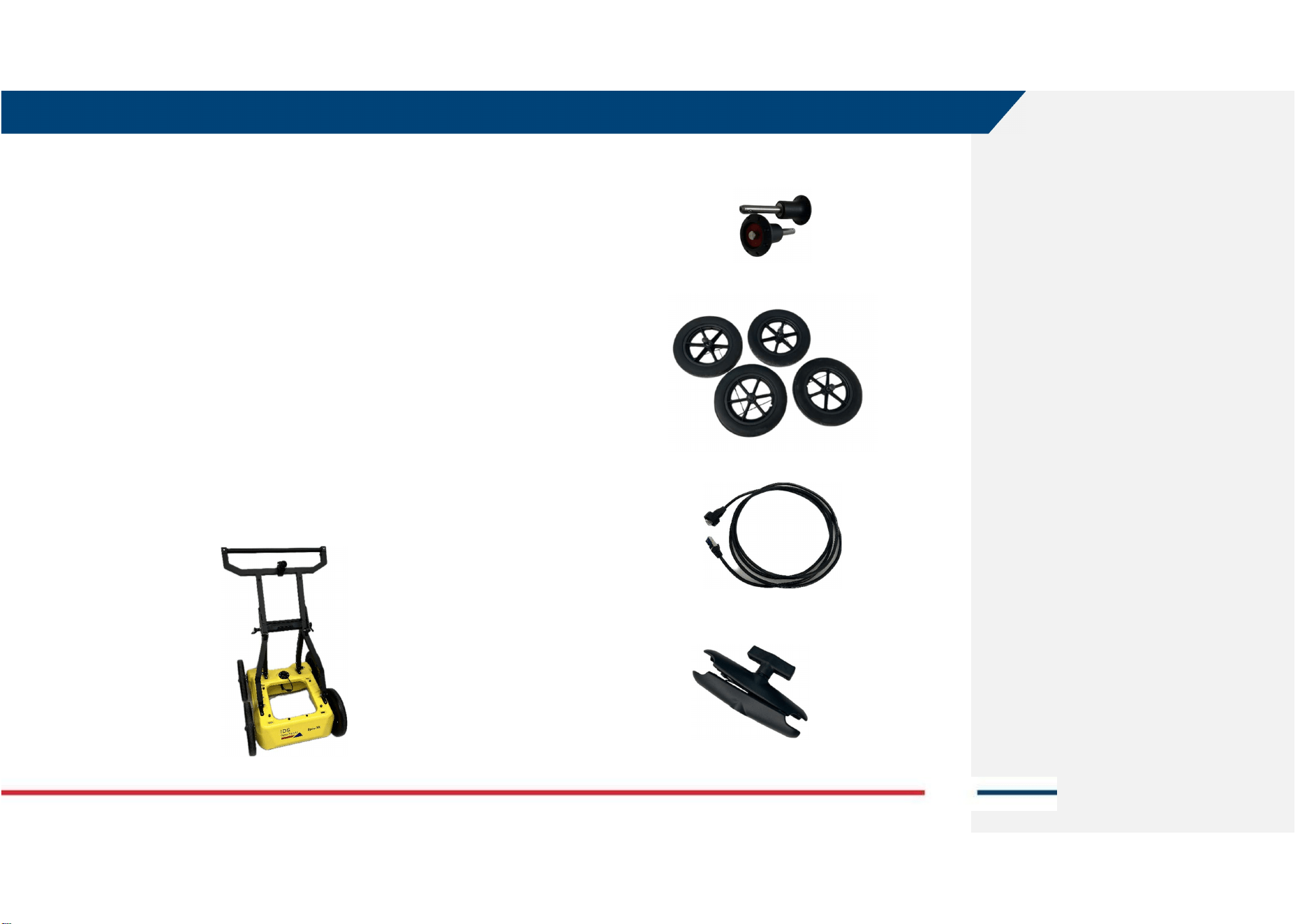
The IDS GeoRadar Opera XR Utility Detection system (SAP 1023280) includes
the following packages:
1. Opera XR (SAP 1023280),
2. Opera XR GNSS Support Kit (Optional, SAP 1020729)
3. Opera XR Off-Road Wheels Kit (Optional, SAP 1020726)
4. Opera XR Shipping Box (Optional, SAP 1026386)
4.1.1 Opera XR (SAP1023280)
The basic kit of Opera XR includes the following items:
a. The Opera XR Cart,
b. (qty. 2) Quick release lock pin 72-12,
c. (qty.4) Airless Wheel 310,
d. (qty. 1) LAN cable 1.5m-5ft. (SAP 970309),
e. (qty. 1) Clamp for tablet holder,
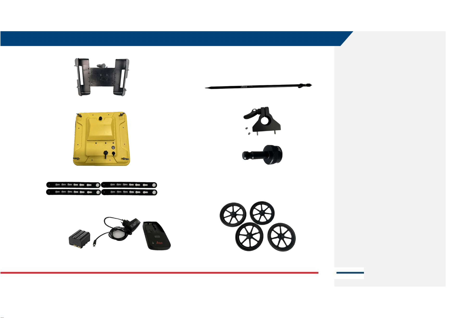
4 GENERAL DESCRIPTION
Mod: MDM/011/M2 Rev 10
IDS GeoRadar Srl MNG/2024/006 Rev. 1.1 15/ 44
g. (qty. 1) Tablet holder,
h. (qty. 1) Antenna Opera XR (AE4H) with sledge,
i. (qty. 4) Antenna lifting belts,
j. (qty. 1) Battery GEB 364 (SAP 954519) and battery charger GKL311
single charger prof 3000 (SAP 799185),
4.1.2 Opera XR GNSS support Kit (SAP 1020729)
The GNSS support kit includes:
a. GNSS pole,
b. GNSS pole support (including 2 screws, 2 washers, and 2 nuts),
c. GAD50, TPS adaptor.
4.1.3 Opera XR Off-Road Wheels kit (SAP 1020726)
The Off-road wheels A380 are characterized by a diameter wider then A310
standard wheels, larger “shoulders”, and they can be easily interchanged
with A310 wheels. They are used for rough surface terrain.
4 GENERAL DESCRIPTION
Mod: MDM/011/M2 Rev 10
IDS GeoRadar Srl MNG/2024/006 Rev. 1.1 16/ 44
4.1.4 Opera XR Shipping Box (SAP 1026386)
The shipping box is an optional item allowing the User to store, and safely
ship, the Opera XR system (GNNS pole support would not fit inside).
5 HOW TO SET UP OPERA XR AND ACCESSORIES
Mod: MDM/011/M2 Rev 10
IDS GeoRadar Srl MNG/2024/006 Rev. 1.1 17/ 44
5 HOW TO SET UP OPERA XR AND ACCESSORIES
This section of the User’s Manual provides a schematic description of how
to assemble Opera XR and its accessories.
5.1 How to set up Opera XR
To assemble Opera XR in its basic configuration, the User should follow the
steps below:
1. After taking off Opera XR from the card box (or the hard shipping
box), remove the (2) pins fastening the rudder on top of the “U-
frame”,
2. Unfold the rudder upward, by holding the handle,
3. Lean the horizontal bar of the rudder against the “U-frame” to
support the rudder itself,
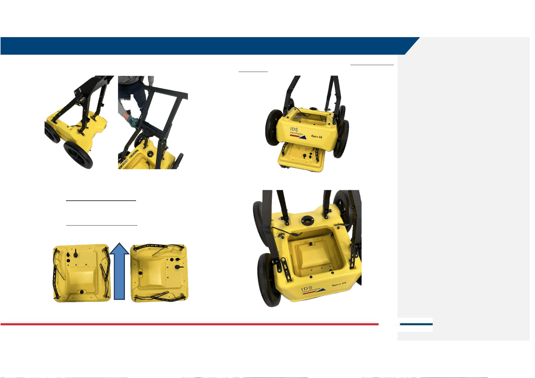
5 HOW TO SET UP OPERA XR AND ACCESSORIES
Mod: MDM/011/M2 Rev 10
IDS GeoRadar Srl MNG/2024/006 Rev. 1.1 18/ 44
4. Enter the (2) pins inside the (2) holes on the side of the rudder, next
to the horizontal bar, to fasten the rudder against the “U-Frame”,
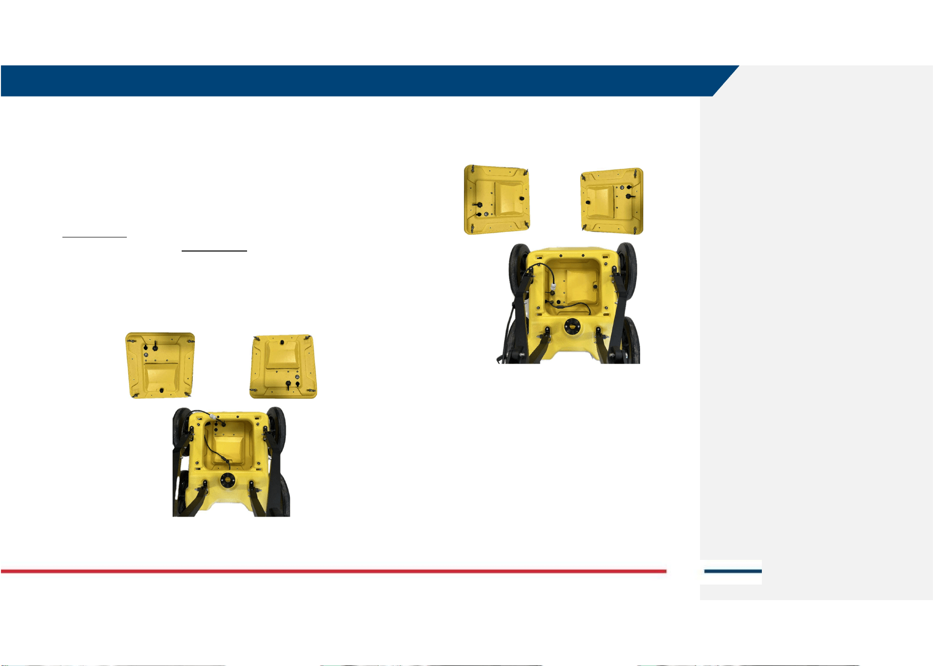
5. Place the Opera XR antenna on the floor, before the cart, and choose
the polarization (i.e.: orientation of the antenna):
a. Polarization HH (left image) LAN and wheel connector
towards the front of the system (or towards the Operator),
OR
b. Polarization VV (right image) LAN and wheel connector
towards the left (or right) side of the Operator,
FRONT SIDE
(HH) (VV)
OPERATOR SIDE
6. Place the Opera XR cart on top of the antenna (HH-oriented in the
image below),
7. Enter the (4) antenna belts inside the (4) holes at each corner of the
cart,
Push
5 HOW TO SET UP OPERA XR AND ACCESSORIES
Mod: MDM/011/M2 Rev 10
IDS GeoRadar Srl MNG/2024/006 Rev. 1.1 19/ 44
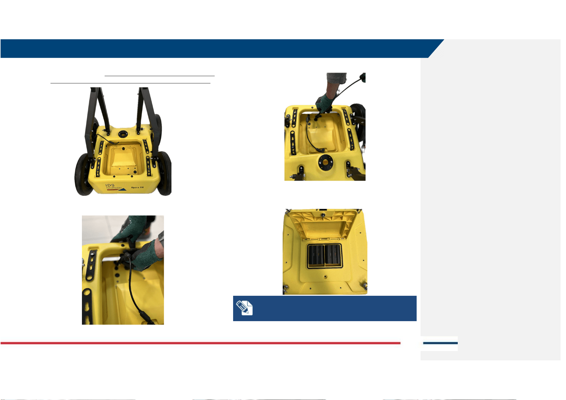
8. Fix the antenna belts to the 4 pins on top of the cart (6 slots are
present on each belt). The height of the bottom of the antenna from
the ground depends on the slot used to fix the antenna to the cart.
9. Plug the wheel cable into the wheel connector on top of the antenna,
10. Plug the LAN cable into the LAN connector on top of the antenna,
11. Open the battery compartment and enter the (2) batteries.
NOTE: Opera XR can operate with one battery only, with
reduced field operability time. Battery hot swap is possible.
5 HOW TO SET UP OPERA XR AND ACCESSORIES
Mod: MDM/011/M2 Rev 10
IDS GeoRadar Srl MNG/2024/006 Rev. 1.1 20/ 44
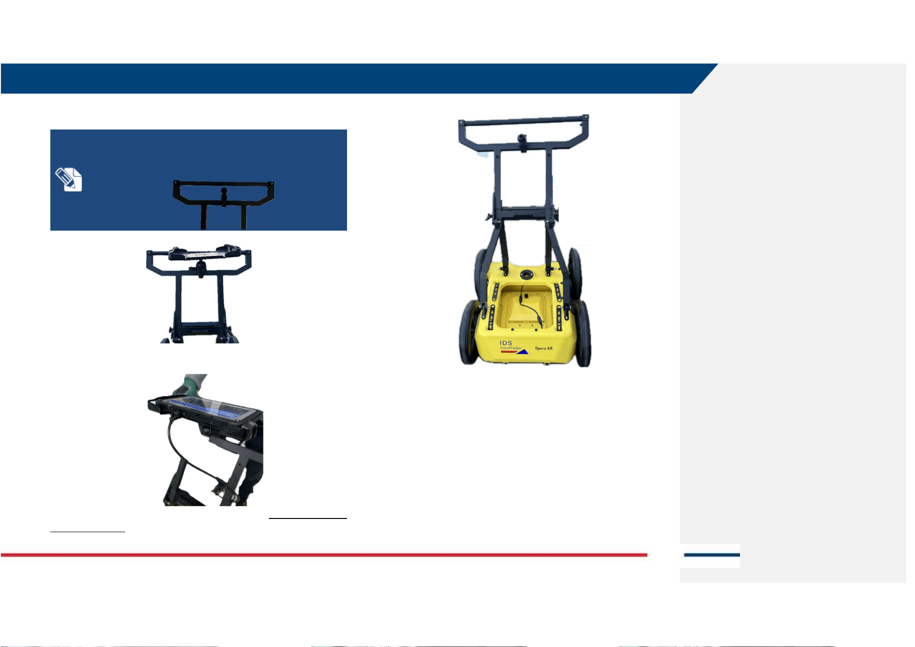
12. Attach the clamp for the tablet holder and the tablet holder, on top
of the rudder, on the horizontal square section bar.
NOTE: the clamp for tablet holder can be either fixed to the
handlebar or to the squared section below handlebar. It is
recommended to mount it as per image below (on squared-
section horizontal bar).
13. Place the tablet on the tablet holder and plug the LAN cable to the
LAN port.
Opera XR after completing the setup is shown in Fig. 1). No field PC is shown
in the image below.
Fig. 1 Opera XR (Basic set up, without Tablet)
5.2 How to set up GNSS support kit
After Opera XR has been mounted as per instruction illustrated in par. 5.1,
the (optional) GNSS pole support can be mounted. Doing so allows the
Operator to collect Opera XR data by pairing an external positioning system
like GNSS or Total Station.
To do this, the Operator should implement the steps below:
5 HOW TO SET UP OPERA XR AND ACCESSORIES
Mod: MDM/011/M2 Rev 10
IDS GeoRadar Srl MNG/2024/006 Rev. 1.1 21/ 44
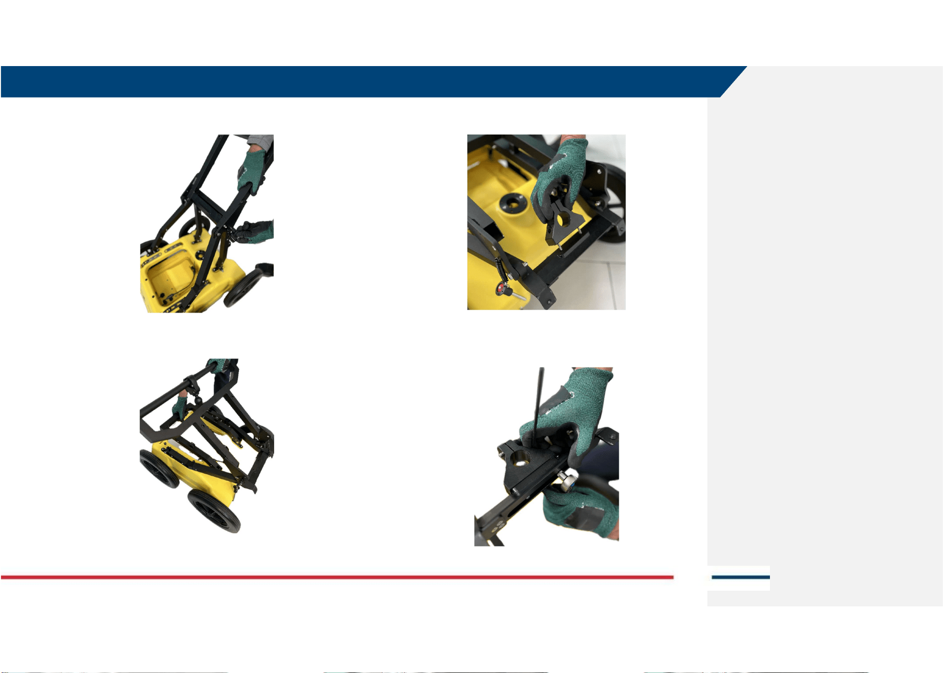
1. Release the rudder from the U-frame by removing the (2) pins on the
side,
2. Fold back the rudder on top of the U-frame, horizontal to the top of
the cart,
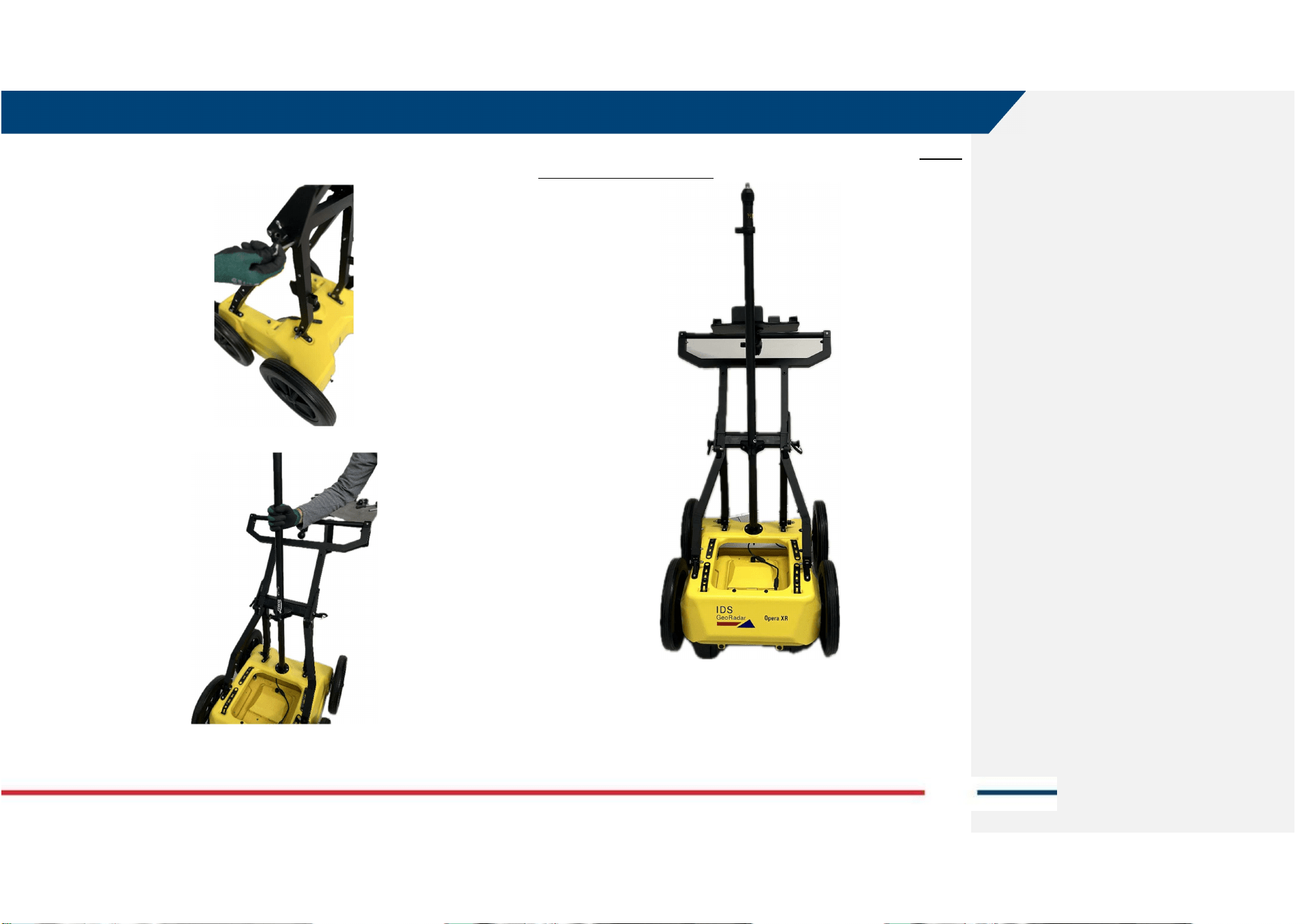
3. Place the GNSS support in the center of the horizontal bar of the
rudder by fitting the (2) screws inside the (2) holes on it,
4. Fix the (2) screws against the (2) bolts and washers provided with the
kit (use Allen key #4 on screw side and socket wrench on the bolt
side),
5 HOW TO SET UP OPERA XR AND ACCESSORIES
Mod: MDM/011/M2 Rev 10
IDS GeoRadar Srl MNG/2024/006 Rev. 1.1 22/ 44
5. Place the rudder and the U-frame in the original position (vertical)
and enter the (2) pins on the side of the rudder,
6. Fit the GNSS pole inside the support just mounted on the rudder.
Opera XR with GNSS kit after completing the setup is shown in Fig. 2. No field
PC is shown in the image below.
Fig. 2 Opera XR with GNSS kit
5 HOW TO SET UP OPERA XR AND ACCESSORIES
Mod: MDM/011/M2 Rev 10
IDS GeoRadar Srl MNG/2024/006 Rev. 1.1 23/ 44
5.3 How to set up Off Road wheels kit
Opera XR basic kit, includes one set of (4) wheels named A310 (the diameter
is 310 mm). It is possible to use larger diameter wheels that also include
larger “shoulders” (namely A380, whose diameter is 380mm). The off-road
kit makes the use of the system on dirt road with rough surface easier.
To mount the off-road kit, the Operator should implement the steps below:
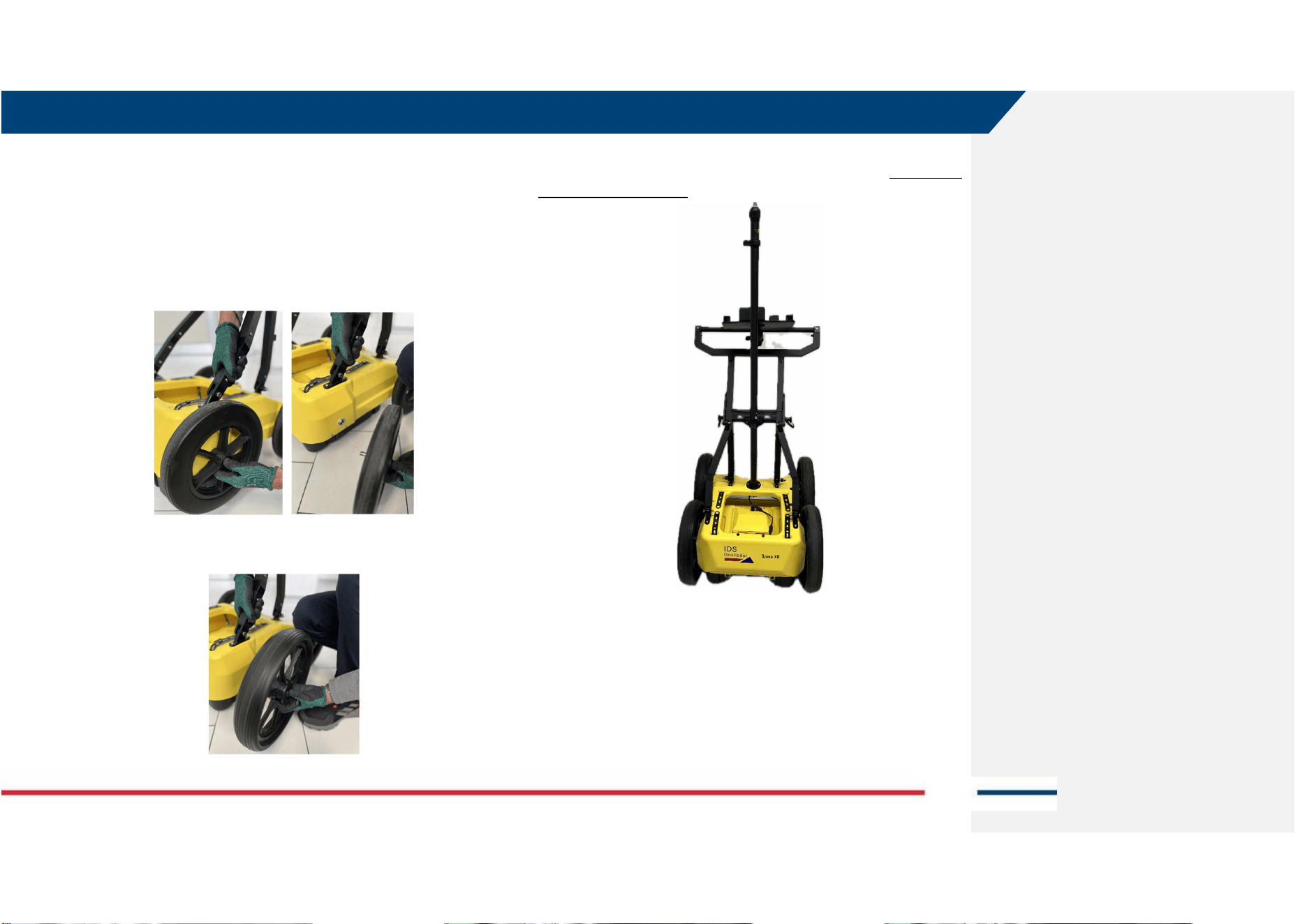
1. Remove the A310 wheel by pressing the button at the center of the
wheel and gently pulling outwards,
2. Replace the A310 wheel just removed with the A380, by the same
operation as before (pushing instead of pulling, now). Repeat the
same operation for the 4 wheels.
Opera XR with GNSS kit and Off-road kit is illustrated in Fig. 3. No field PC is
shown in the image below.
Fig. 3 Opera XR with GNSS kit and Off-road kit
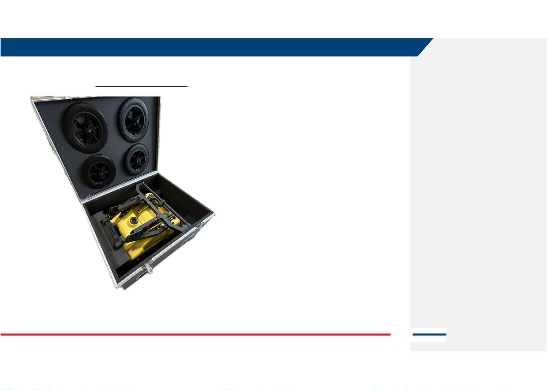
5.4 How to store Opera XR into the shipping box
Opera XR and accessories are shipped inside purpose-built card boxes.
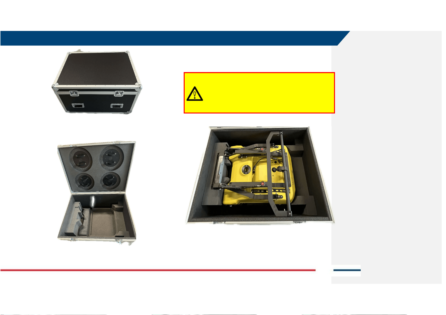
However, a hard case (flight case) is also available as optional, Fig. 4. The hard
case allows for safer transport of the whole system, but the GNSS pole
support.
5 HOW TO SET UP OPERA XR AND ACCESSORIES
Mod: MDM/011/M2 Rev 10
IDS GeoRadar Srl MNG/2024/006 Rev. 1.1 24/ 44
Fig. 4 Hard case for Opera XR
The internal cases include precast foam to host the A310 wheels, and
Opera XR with A380 wheels (Fig. 5).
Fig. 5 Internal of the Opera XR hard case
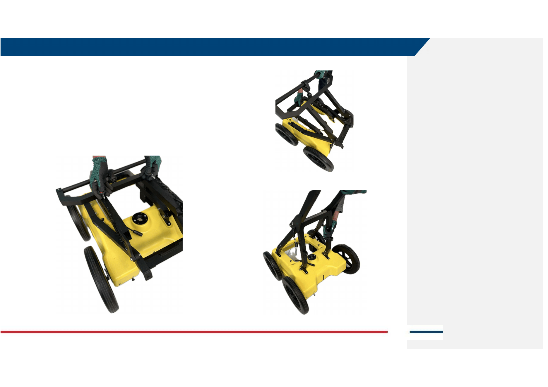
The correct way to store the system inside includes the following steps:
1. Place the Opera XR antenna first and then the Cart on top of it,
2. Enter the (2) pins on top rudder to block this against the U-frame,
WARNING:
Lifting Opera XR and antenna together to fit inside the hard case
may cause injury to the Operator and damage to the system.
PRECAUTION:
lift and place inside the hardcase the Opera XR antenna first and
then the Opera XR cart, separately.
5 HOW TO SET UP OPERA XR AND ACCESSORIES
Mod: MDM/011/M2 Rev 10
IDS GeoRadar Srl MNG/2024/006 Rev. 1.1 25/ 44
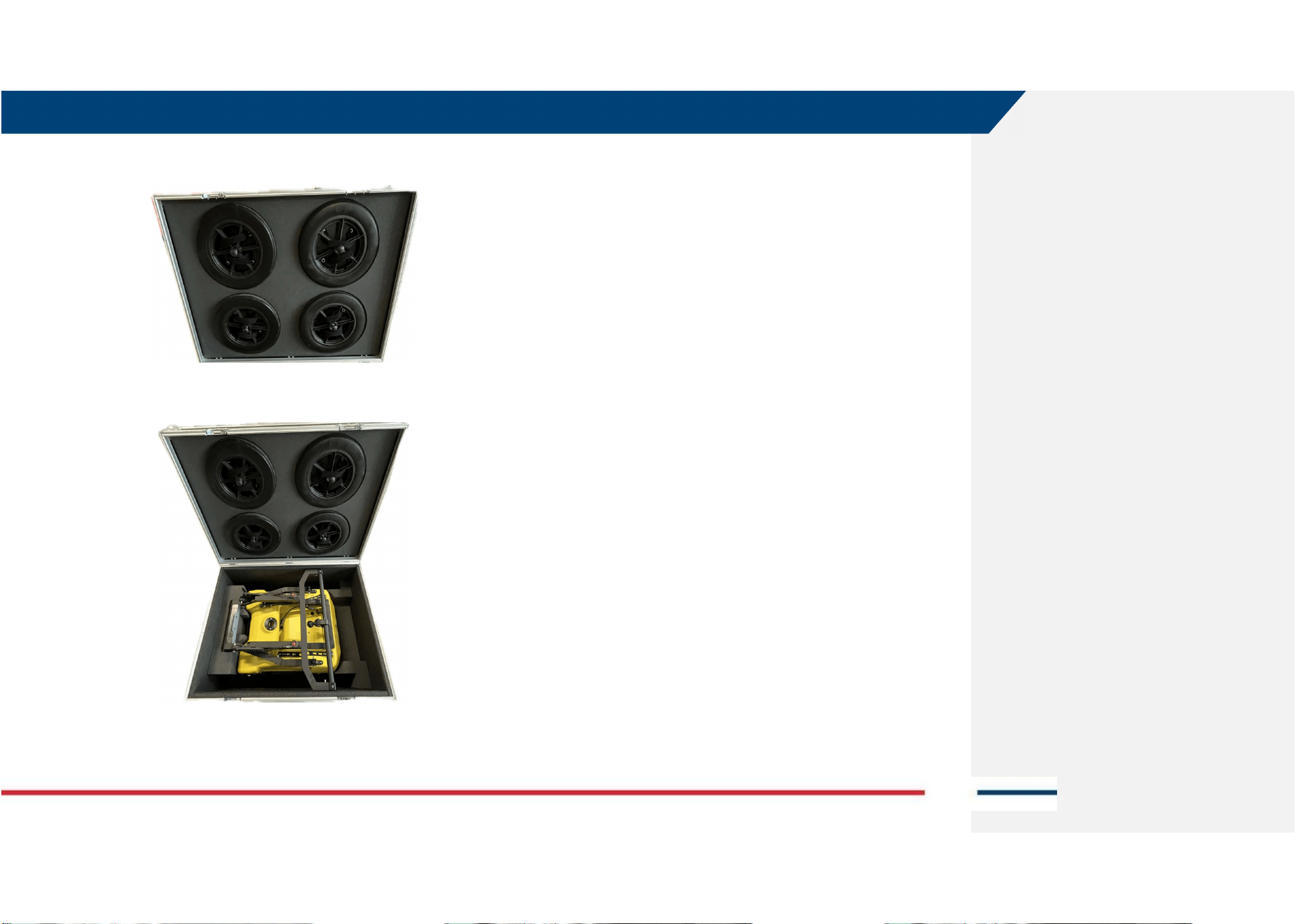
3. Place the A310 wheel on the foam of the cover and fix them all using
the Velcro.
Opera XR correctly placed inside the shipping box, is illustrated in Fig. 6.
Fig. 6 Opera XR inside the hard shipping box
6 HOW TO WORK ON SITE WITH OPERA XR
Mod: MDM/011/M2 Rev 10
IDS GeoRadar Srl MNG/2024/006 Rev. 1.1 26/ 44
6 HOW TO WORK ON SITE WITH OPERA XR
Opera XR is a Georadar system that can be deployed on site including several
positioning systems (i.e.: Quick Scan, Grid, GNSS, Robotic Total Station). Its
structure is designed with the aim to cover the largest possible applications
and field conditions.
6.1 How to set up Opera XR in HH or VV Polarization
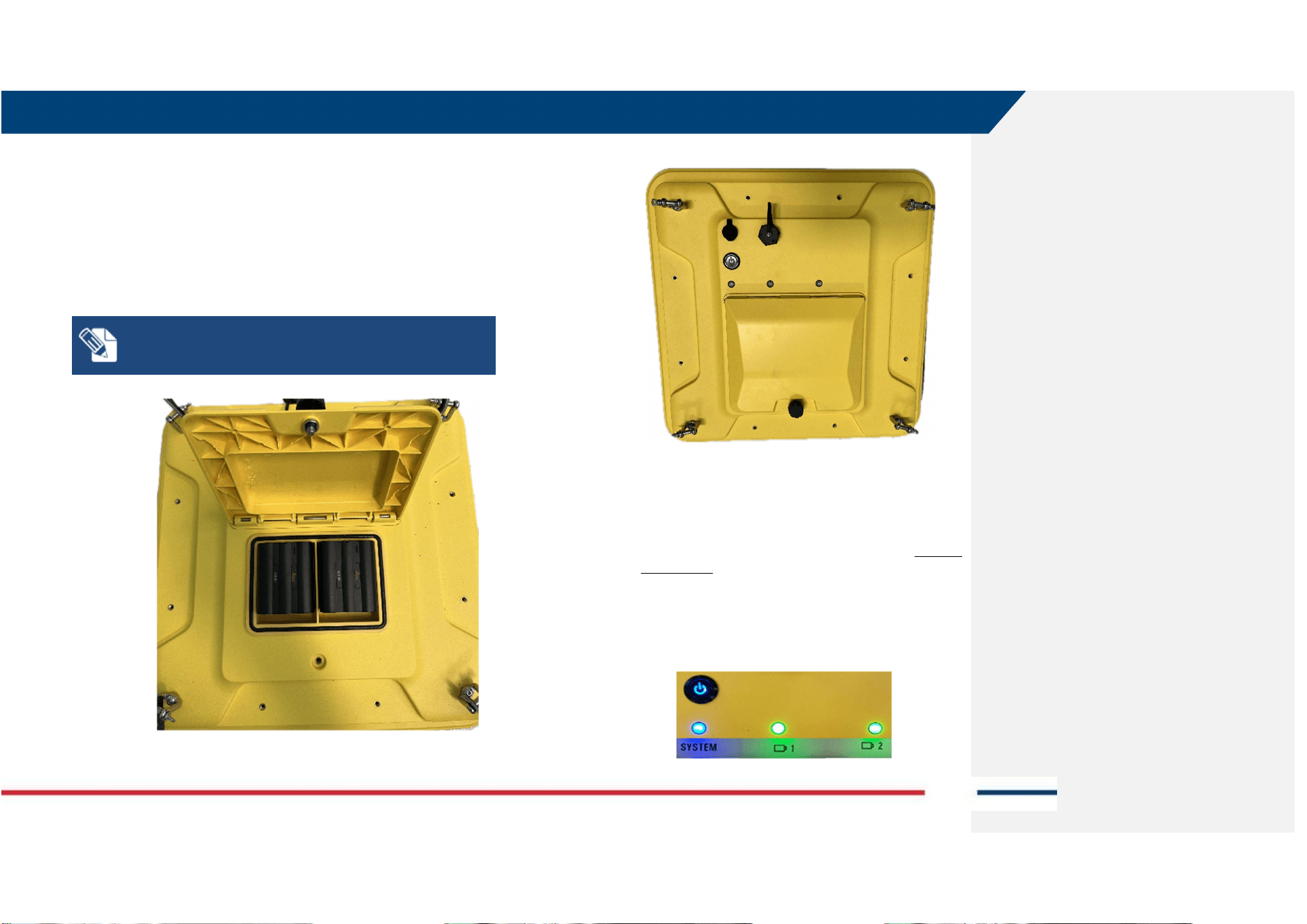
Opera XR can be deployed in 2 different orientations of the antenna, namely
in HH Polarization (Horizontal, internal dipoles perpendicular with respect
to the push/pull direction) or VV Polarization (Vertical, internal dipoles
parallel with respect to the push/pull direction).
1. HH Polarization acquisition mode:
Front of the antenna (with respect to direction of acquisition) with battery
compartment opposite to the Operator (or towards Operator).
FRONT SIDE
OR
OPERATOR SIDE
2. VV Polarization acquisition mode:
Front of the antenna (with respect to direction of acquisition) with battery
compartment right to the Operator (or left to the Operator).
FRONT SIDE
OR
OPERATOR SIDE
Antenna
TOP View
Opera XR
TOP View
Antenna
TOP View
Opera XR
TOP View
6 HOW TO WORK ON SITE WITH OPERA XR
Mod: MDM/011/M2 Rev 10
IDS GeoRadar Srl MNG/2024/006 Rev. 1.1 27/ 44
6.2 How to connect the field PC and the Opera XR antenna
The connection between the field PC (where uMap-Logger, the data
acquisition SW, is installed) and the Opera XR is fulfilled via LAN Cable.
The steps to start up the system before commencing any data acquisition on
site are:
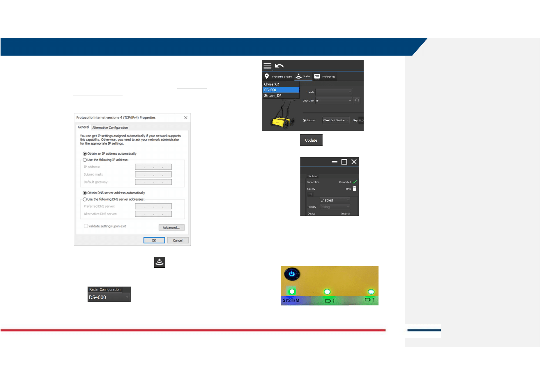
a. Open the battery compartment on top of the antenna
case and insert the (2) batteries.
NOTE: Opera XR can operate with one battery only, with
reduced field operability time. Battery hot swap is possible.
b. Then close the battery compartment.
c. Connect the field PC and the Opera XR antenna via the
LAN cable provided with the system: on one side to the
antenna LAN connector, on the opposite side to the LAN
port of the PC.
d. Press the O/I button beside the battery compartment to
start up the antenna. This button shall turn blue. Antenna
Led status is:
i. System LED BLU: Antenna powered but not
connected to PC
ii. Battery 1 LED Green: Fully charged
iii. Battery 2 LED Green: Fully charged
6 HOW TO WORK ON SITE WITH OPERA XR
Mod: MDM/011/M2 Rev 10
IDS GeoRadar Srl MNG/2024/006 Rev. 1.1 28/ 44
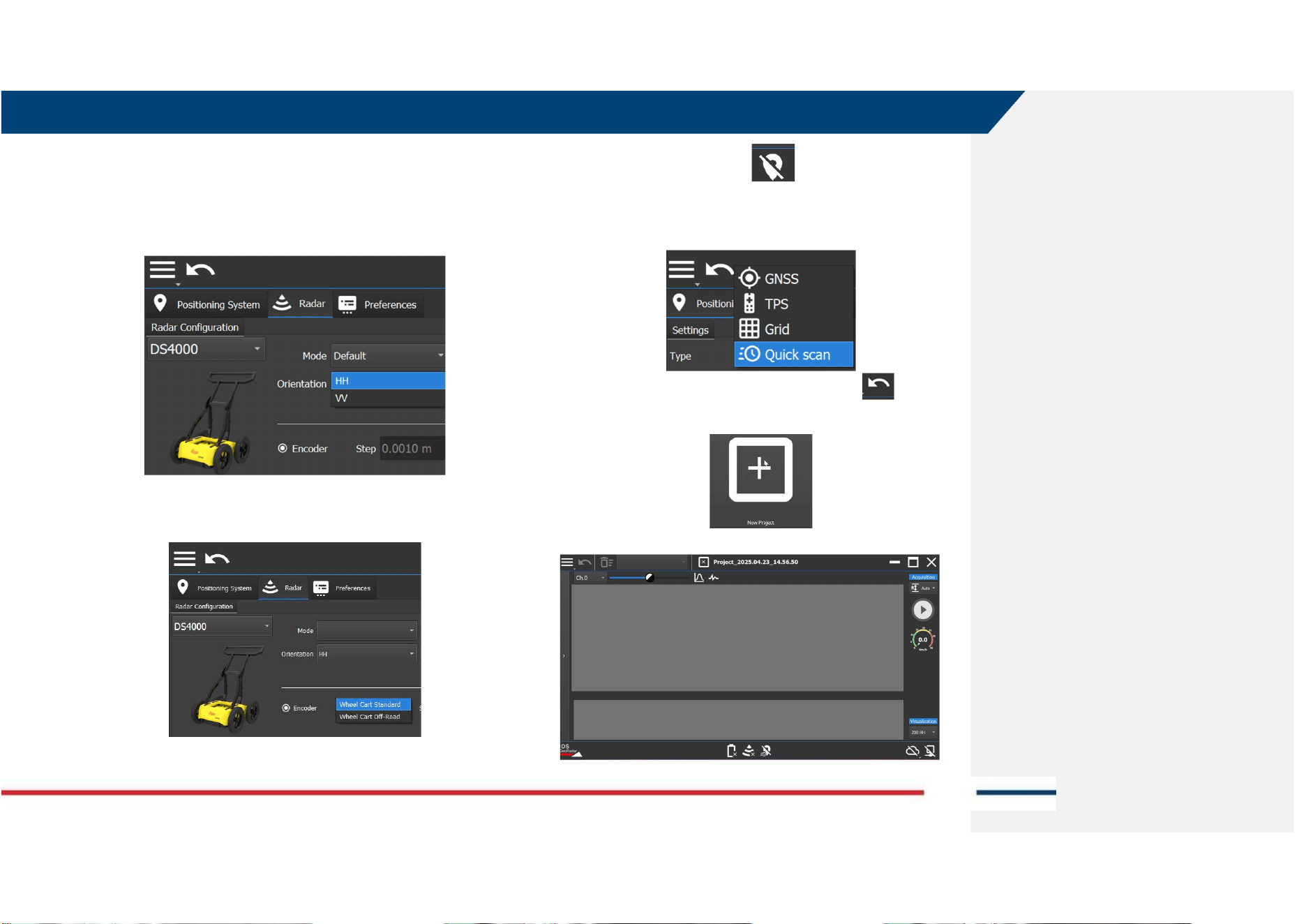
e. Turn on the field PC where the uMap-Logger software is
installed (note: refer to the specific uMap-Logger user’s
manual for details on installation. Also, firewall and
antivirus must be OFF). The IP address of the Ethernet port
of the PC must be set to DHCP (Dynamic mode and NOT
Static IP address).
f. Turn on uMap-Logger,
g. Press on the Radar Settings icon of the SW main
page,
h. Select DS4000 from the Radar Configuration drop-down
menu ,
i. press update , and the connection between the
antenna and the PC is established.
j. Antenna LED status is now:
i. System LED Green: System powered and
connected to PC
ii. Battery 1 LED Green: Fully charged
iii. Battery 2 LED Green: Fully charged
Opera XR, is now ready to be used on site for data acquisition.
6 HOW TO WORK ON SITE WITH OPERA XR
Mod: MDM/011/M2 Rev 10
IDS GeoRadar Srl MNG/2024/006 Rev. 1.1 29/ 44
6.3 How to collect Opera XR data in Quick Scan mode
The steps to be taken to start gathering data in Quick Scan mode are:
1. Follow all steps described in par. 6.1 and par 6.2,
2. Select the Antenna orientation (HH or VV), from the Orientation
drop down menu,
3. Select Encoder type (depending if A310 or A380 Wheels are
mounted),
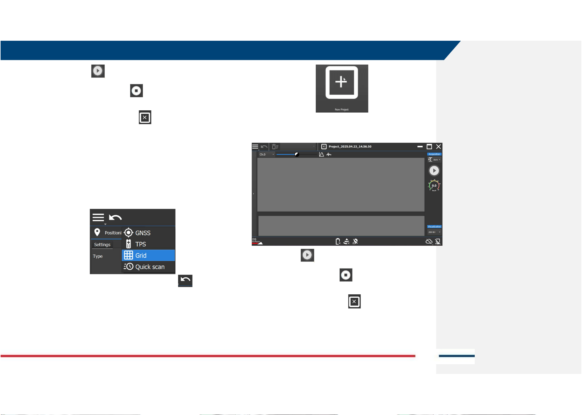
4. Click on the positioning icon to switch to the Positioning
view tab,
5. From the drop-down menu of Positioning tab select the Quick Scan
Mode,
6. Go back to the previous page by pressing the icon ,
7. Then, press on the New Project icon to start a new project window.
8. In the Project Window:
6 HOW TO WORK ON SITE WITH OPERA XR
Mod: MDM/011/M2 Rev 10
IDS GeoRadar Srl MNG/2024/006 Rev. 1.1 30/ 44
9. press the Play button to start the acquisition,
10. Press the Stop Acquisition button to close the swath
acquisition,
11. Press the close current project button to close the active
project.
12. Refer to uMap-Logger Software User’s Manual for specific software
tools.
6.4 How to collect Opera XR data in GRID mode
The steps to be taken to start gathering data in GRID mode, are:
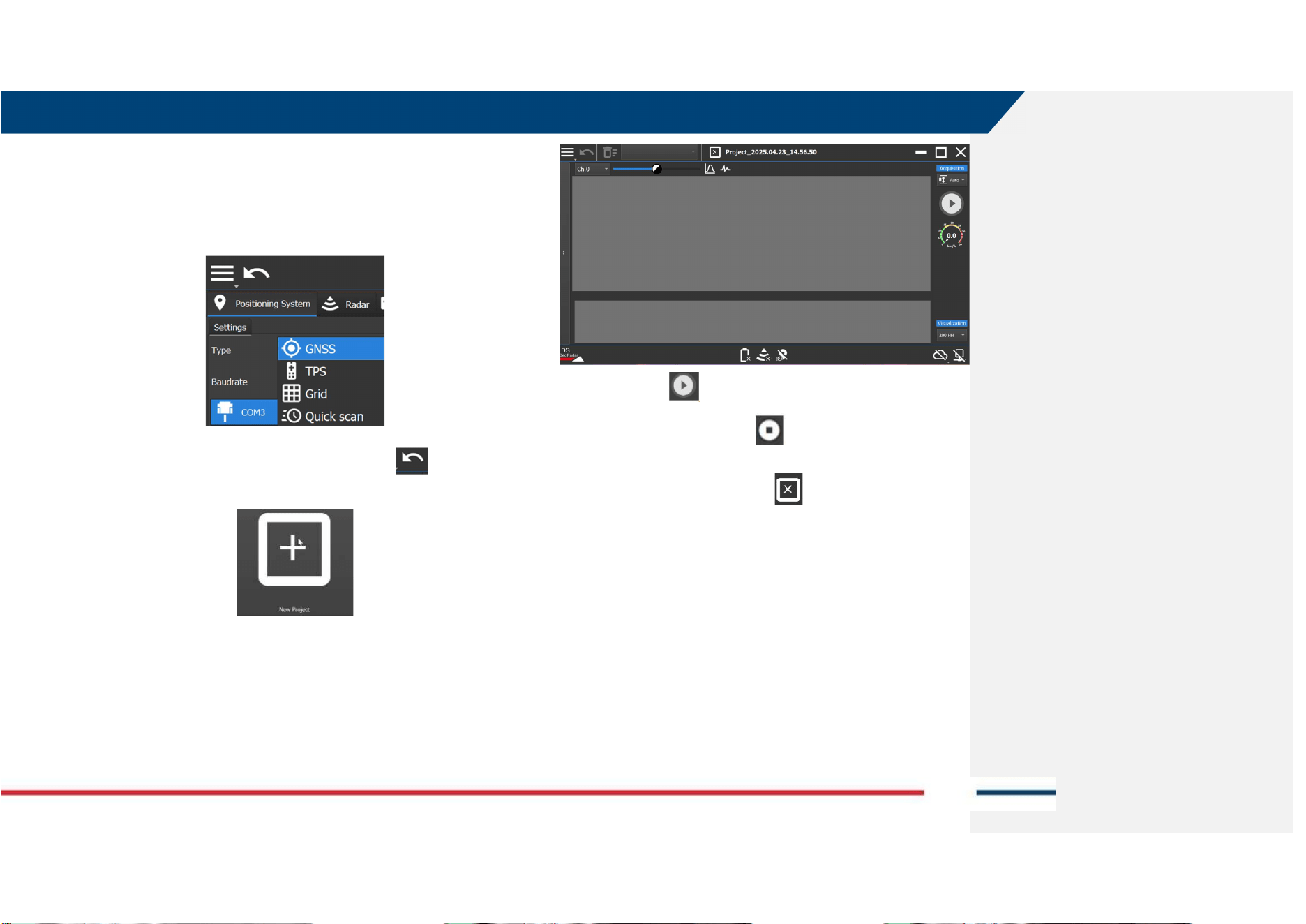
1. Select Steps 1 to 4 of par 6.3,
2. From the Positioning tab select the GRID Mode from the drop-down
menu,
3. Go back to the previous page by pressing the icon ,
4. Then, press on the New Project icon to start a new project window.
5. Customize the Grid trajectory, based on the project specification,
and use the tools described in uMap-logger User’s manual.
6. In the Project Window:
7. press the Play button to start the acquisition,
8. Press the Stop Acquisition button to close the swath
acquisition,
9. Press the close current project button to close the active
project.
10. Refer to uMap-Logger Software User’s Manual for specific software
tools.
6 HOW TO WORK ON SITE WITH OPERA XR
Mod: MDM/011/M2 Rev 10
IDS GeoRadar Srl MNG/2024/006 Rev. 1.1 31/ 44
6.5 How to collect Opera XR data in GNSS mode
The steps to be taken to start gathering data in GNSS mode are:
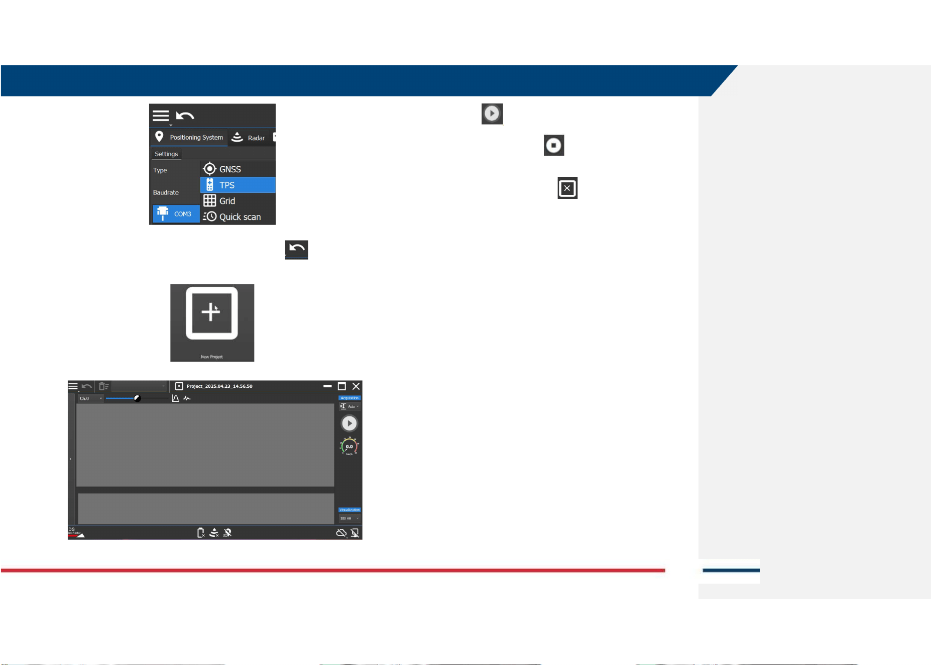
1. Follow all steps 1 to 4 of par 6.3,
2. From the Positioning tab select the GNSS Mode from drop-down
menu,
3. Go back to the previous page by pressing the icon ,
4. Then, press on the New Project icon to start a new project window.
5. In the Project Window:
6. press the Play button to start the acquisition,
7. Press the Stop Acquisition button to close the swath
acquisition,
8. Press the close current project button to close the active
project.
9. Refer to uMap-Logger Software User’s Manual for specific software
tools.
6.6 How to collect Opera XR data in TPS mode
The steps to be taken to start gathering data in TPS mode are:
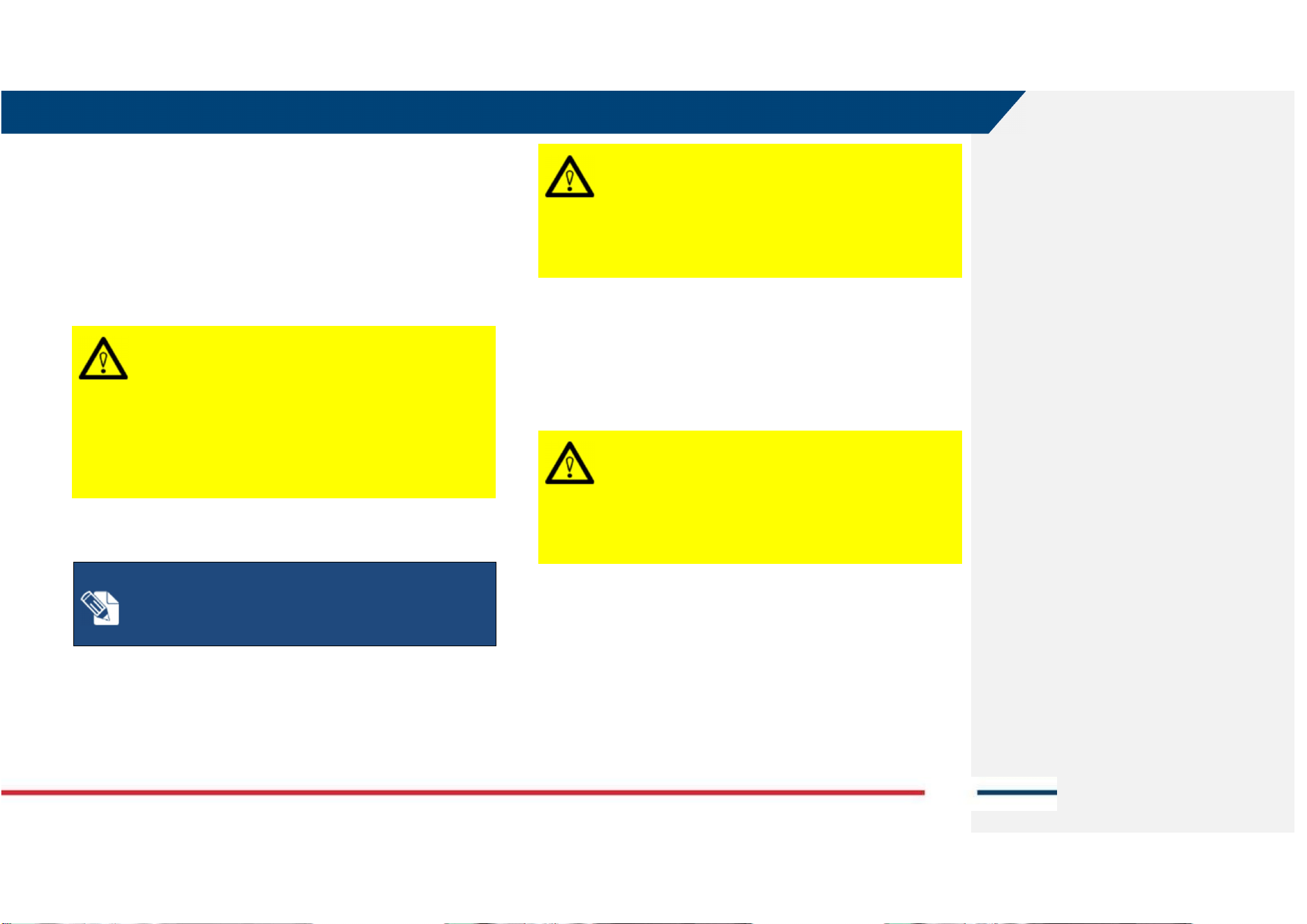
1. Follow all Steps 1 to 4 of par 6.3,
2. From the Positioning tab select the TPS Mode from drop-down
menu,
6 HOW TO WORK ON SITE WITH OPERA XR
Mod: MDM/011/M2 Rev 10
IDS GeoRadar Srl MNG/2024/006 Rev. 1.1 32/ 44
3. Go back to the previous page by pressing the icon ,
4. Then, press on the New Project icon to start a new project window.
5. In the Project Window:
6. press the Play button to start the acquisition,
7. Press the Stop Acquisition button to close the swath
acquisition,
8. Press the close current project button to close the active
project.
9. Refer to uMap-Logger Software User’s Manual for specific software
tools.
7 CARE AND TRANSPORT
Mod: MDM/011/M2 Rev 10
IDS GeoRadar Srl MNG/2024/006 Rev. 1.1 33/ 44
7 CARE AND TRANSPORT
7.1 Cleaning Information
Before cleaning any of the external parts of the apparatus, make sure that all
cables and wires have been unplugged, including the power supply cable. If
a damp cloth is used, make sure it is not wet, to avoid any damage to the
electrical components of the equipment. Wait until the equipment is totally
dry before reconnecting the cables.
CAUTION: DAMAGE TO ELECTRICAL COMPONENTS
If a damp cloth is used while cleaning the system or part of it,
make sure that this is not wet, to avoid any damage to the
electrical components of the equipment
PRECAUTION: Before cleaning any of the external parts of the
apparatus, make sure that all cables and wires have been
unplugged, including the power supply cable.
The Opera XR should be cleaned periodically using a damp cloth.
NOTICE: If the system is severely dirty or clogged by dust,
connectors and encoders may not work properly.
Precautions:
After a field work, check the conditions of the system and clean
it if necessary.
Do not use solvents or abrasive detergents.
CAUTION: DAMAGE TO ELECTRICAL COMPONENTS
Consider only cleaning products appropriate for electronic
components.
PRECAUTION: Verify if the cleaning products are compliant
with electronic devices.
Do not apply liquid directly to the electrical contacts of the various
connectors.
If a specific spray is used to clean the PC monitor, make sure it is not
flammable; in any case, do not spray it directly on the screen, instead, spray
it onto the cleaning cloth.
CAUTION: DAMAGE TO ELECTRICAL COMPONENTS
Flammable spray could damage the electronic devices, as
controller laptop.
PRECAUTION: Verify if the cleaning products are compliant
with electronic devices.
7.2 Battery Removal Information
Remove batteries from the product and the charger before storing.
• After storage recharge batteries before using.
• Protect batteries from damp and wetness. Wet or damp batteries must be
dried before storing or use.
• A storage temperature range of −20 °C to +50 °C/
−4 °F to +122 °F
in a dry
7 CARE AND TRANSPORT
Mod: MDM/011/M2 Rev 10
IDS GeoRadar Srl MNG/2024/006 Rev. 1.1 34/ 44
environment is recommended to minimize self-discharging of the battery.
• At the recommended storage temperature range, batteries containing a
40% to 50% charge can be stored for up to one year. After this storage
period the batteries must be recharged.
As for the Laptop Batteries please, do refer to the PC manufacturer user’s
manual.
7.3 Periodical Check
The Operator should periodically check the status of the antenna sledge,
shells, all cables, any rotating part, and any (potentially) consumable part.
The system must not be used in case of any malfunctioning or broken part,
as this may cause other parts to be damaged and/or malfunction
consequently.
NOTICE: The Sledges should be periodically checked out to
verify their status, and should be removed and replaced, when
needed. Prior starting any survey, the status of the sledge
should be verified for integrity.
Precautions:
If the antenna shell is exposed, even partially, because of the
sledge being consumed, the sledge must be replaced
immediately.
NOTICE: All the cables and connectors should be verified at
each use of the system
Precautions:
In case of any damage of cables or connectors, immediately
inform IDS GeoRadar to follow up on removal and
replacement.
NOTICE
:
All the connectors on the antenna
and
the
accessories, must be plugged at any time either by the
corresponding cable plug, or by the connector cap, when not
in use. This is to prevent dust or water ingress, that may
damage the connector itself and its functionality.
Precautions:
Verify the connectors status before running a survey.
7.4 Proper system use
Always use the system as indicated in this manual, by following instructions.
When not in use, the system should always be transported and/or shipped
by using the case with which the system is delivered. Transporting and/or
shipping the system outside this packaging or by using other shipping boxes
may cause the system, or part of it, to be damaged.
CAUTION: MECHANICAL DAMAGE OF THE SYSTEM
Transporting and/or shipping the system outside its original
packaging or by using other shipping boxes may cause the
system, or part of it, to be damaged.
PRECAUTION: The system should always be transported
and/or shipped by using the hard case with which the system
is delivered.
7 CARE AND TRANSPORT
Mod: MDM/011/M2 Rev 10
IDS GeoRadar Srl MNG/2024/006 Rev. 1.1 35/ 44
8 IDS GEORADAR SUPPORT
8.1 myWorld
IDS GeoRadar is part of Hexagon Geosystems division, having Leica
Geosystems as parent company. myWorld platform of Leica Geosystems
offers a wide range of services, information, and training material. With
direct access to myWorld, the User can access all relevant services. The
availability of services depends on the instrument model.
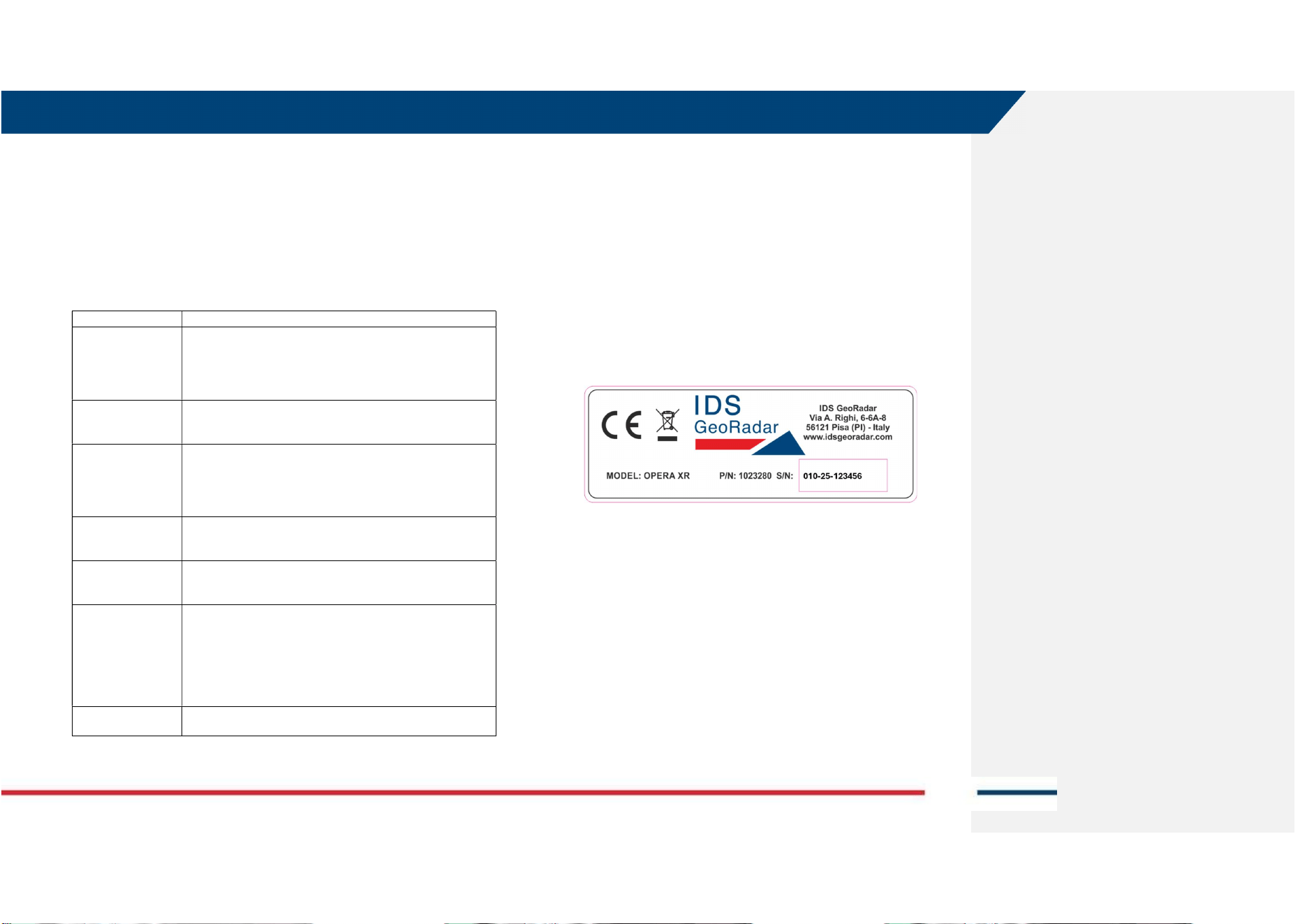
SERVICE
DESCRIPTION
myProducts
Add all IDS GeoRadar products that you and your company own
and explore your world of Leica Geosystems. View detailed
information on your products and update your products with
the latest software and keep up to date with the latest
documentation.
myService
View the current service status and full-service history of your
products in IDS GeoRadar service centres including detailed
information on the services performed on your system.
mySupport
Create new support requests for your products that will be
answered by your local Support Team. View the complete
history of your support requests and view detailed information
on each request in case you want to refer to previous support
requests.
myLearning
Welcome to the home of Leica Geosystems online learning!
There are numerous online courses – available to all customers
with products that have valid CCPs (Customer Care Packages).
myTrustedServices
Add your subscriptions and manage users for Leica Geosystems
Trusted Services, the secure software services, that assist you
to optimise your workflow and increase your efficiency.
mySmartNet
HxGN SmartNet is the GNSS correction service built on the
world’s largest reference station network, enabling GNSS-
capable devices to quickly determine precise positions in the
range of one-to-two-centimetre accuracy. The service is
provided 24/7 by a highly available infrastructure and
professional support team with more than 10 years of
experience reliably delivering the service.
myDownloads
Downloads of software, manuals, tools, training material and
news for IDS GeoRadar products.
8.2 How to manage return for Service
On occasions, your GPR may need to be returned to the factory for repairs.
These events, depending on circumstances, may be handled under
maintenance or warranty conditions.
IDS GeoRadar, implements an internal ticket system to handle the repair of
its Products worldwide. In this respect, for the global IDS Customer Support
to be able to troubleshoot in case of need, it is necessary to identify the GPR
system first hence, it is mandatory providing information including Serial
number and Product Number of the system or part of it that need repair.
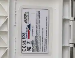
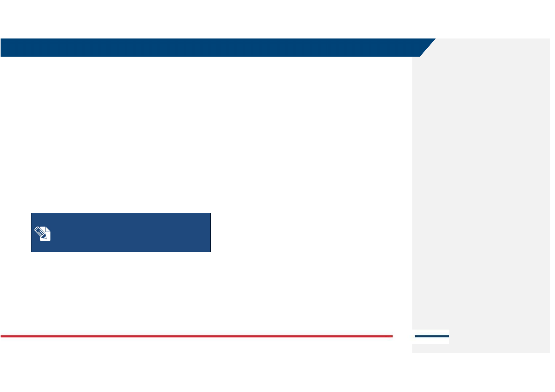
This information may be found on a label placed on top of the system (e.g.:
inside the battery housing, on top of the antenna, on the side of the rudder,
on top of the SCU, etc...). An example of this label is illustrated in Fig. 7.
Fig. 7 Example of an IDS GPR system label
In any event, the workflow to follow up on a support request is:
1. Contact, by using the local Support mailing list, your local
representative of IDS Customer Support, or enter a support case into
the mySupport page of myWorld, Indicating the following:
a. Type of System or part of it (defined by Product Number or
Article number, that is PN 1023280 in Fig. 7)
b. Serial Number (SN 010-25-123456, in Fig. 7)
c. Type of issue
2. The local Representative of IDS Georadar Customer Support or the
Central IDS Georadar Customer Support shall follow up on the case
7 CARE AND TRANSPORT
Mod: MDM/011/M2 Rev 10
IDS GeoRadar Srl MNG/2024/006 Rev. 1.1 36/ 44
by a first level, remote troubleshooting to assess the system and the
possible issue.
3. If a further, direct assessment of the system is necessary, the system
shall be returned for analysis. Based on this, a repair under warranty
or maintenance conditions, may be carried out. Depending on cases
and the type of possible repair, return may be towards the local
Representative of IDS or to the IDS GeoRadar main factory.
4. Prior return of the goods, wait for the IDS Georadar logistic office to
provide a reference number for the return case and shipping
instructions.
5. As the system reaches IDS Georadar repair premises, this is analyzed
to find the root cause of the issue, and repaired ONLY after signed
approval of the quotation, in case where the warranty does not
apply. The status of the repair may be checked onto the mySupport
page of myWorld.
6. At the end of the repair, the system is shipped back to the shipping
address indicated at the beginning of the procedure, and this is
conducted based on contractual agreements.
NOTICE: The above, is meant solely as a broad indication of
the workflow for the return of a system for repair.
Precautions:
Please, refer to the Contractual Terms and Conditions for more
detailed information.

APPENDIX A DISCLAIMER
Mod: MDM/011/M2 Rev 9
IDS GeoRadar Srl MNG/2024/006 Rev. 1.1 37/ 44
APPENDIX A DISCLAIMER
1. General
i. The present Disclaimer applies to all products designed, produced
and distributed by IDS GeoRadar S.r.l., its Subsidiaries, Affiliated
and authorized Distributors (the “Products”). IDS GeoRadar S.r.l.
reserves full ownership and intellectual property rights of any
“Information” contained in this Disclaimer including Trade Marks
and Graphics. No part of this Disclaimer may be used or
reproduced in any forms without the prior written agreement of
IDS GeoRadar S.r.l.
ii. In the event that any provision of this Disclaimer may be invalid,
unlawful or incapable of being enforced by a rule of law, all other
provisions shall, nonetheless, remain in full force and effect. Failure
to either enforce or exercise any right, privilege, or legal remedy at
any time, any provision contained in this Disclaimer, shall not be
deemed a waiver of such provisions or right, remedy, or privilege.
iii. This Disclaimer shall be interpreted, governed, construed and
enforced in accordance with the laws of Italy. User/Buyer hereby
consents to the exclusive jurisdiction of Pisa.
2. Initial Precautions for Setting-up and Use of the Products.
i. The User/Buyer, for setting-up and using the Products, shall consult
the official documentation provided by IDS GeoRadar S.r.l. for the
Products (“Reference Documentation”) and carefully ascertain the
compliance with national laws and requirements, which may limit
or even forbid their use.
ii. For Products which shall operate by circulation in Public
Areas/Roads, with or without moving traffic, Buyer/User shall verify
the approval of local authority and/or site’s owner according to their
specific procedures. IDS GeoRadar S.r.l. shall not be liable for any
direct, indirect, special, incidental or consequential damages or
injuries, including without limitation, lost revenues or lost profits,
resulting by un-authorized use of the Products in Public
Areas/Roads.
iii. Buyer/User further warrants:
that these Products are not being used, in the design,
development, production or use of chemical, biological,
nuclear ballistic weapons. Buyer/ User will defend,
indemnify and hold IDS GeoRadar S.r.l. harmless against any
liability (including attorney’s fees) for non-compliance with
the terms of this article.
That, if IDS GeoRadar S.r.l. requires that Buyer/User shall
carry out a training with reference to some Product
categories, no operation or use of the Products shall be
started before its designated Operator/s has got the User
Certificate, as defined by IDS GeoRadar S.r.l. specific
procedure which the Buyer confirms to know and accept.
iv. For Products which include specific “Operational” software with
automatic data processing and analysis “Tools”, e.g. the IBIS
Products and Hydra Products, User shall be aware that the results
provided by these “Tools” may be not error free. User that
completely relies on the outcomes provided by these Tools only,
does it at his own risk.
v. In no event IDS GeoRadar S.r.l. shall be liable for special, direct,
indirect, incidental, exemplary, punitive or consequential damages
including, but not limited to, loss of profits or revenue, caused by
the use of the Products, either separately or in combination with
other products or relied upon the results provided by the above
“Tools”.
3. Disclaimer for the “Use” of the Products.
i. The User shall follow the instructions provided by IDS GeoRadar
S.r.l. in its official “Reference Documentation” for the Product, in
particular the User’s Technical Manual which contains all the
specific steps and recommendations for a correct setting-up and use
of the Product.

APPENDIX A DISCLAIMER
Mod: MDM/011/M2 Rev 9
IDS GeoRadar Srl MNG/2024/006 Rev. 1.1 38/ 44
ii. In no event IDS GeoRadar S.r.l. shall be liable for special, direct,
indirect, incidental, exemplary, punitive or consequential damages
including, but not limited to, loss of profits or revenue, caused by
the missed or incomplete observance of the instructions and
prescriptions for the use of the Products, either separately or in
combination with other products, including but not limited to the
following main aspects:
a. Use of IDS GeoRadar S.r.l. Products outside its limitation of
use, without proper and adequate scientific/technical
knowledge or without specific training.
b. Use of results/outcomes of the measurements performed
by the Product aimed to safety aspects without using
adequate control procedures and assessment by skilled
personnel.
c. Opening of the Equipment (for HW Products) without
express written authorization of IDS GeoRadar S.r.l.;
d. Unauthorized changes and additions to the Products.
e. Use of the Products connected to suspected non-working
equipment or with equipment (mainly PC) having
characteristics not in compliance with the required
specifications of IDS GeoRadar S.r.l. not expressly
authorized by IDS GeoRadar S.r.l.;
f. Poor or faulty operation of the electrical and
telecommunication networks not directly managed by IDS
GeoRadar S.r.l. or its delegates.
g. Poor or faulty operation Software/Hardware of the third
parties connected with IDS GeoRadar S.r.l. Equipment.
h. Poor or faulty operation of the Products due to Software
Virus which infected the Products after their delivery.
i. Use of the Products which have encountered suspected
manumissions, accidents, electrostatic shocks, flashes, fire,
earthquake, flooding or other natural disasters or
unexpected events.
j. Use or storage of the Products outside the limits of the
“Operational Temperature Range” specified by IDS
GeoRadar S.r.l.
APPENDIX B TECHNICAL SPECIFICATIONS
Mod: MDM/011/M2 Rev 9
IDS GeoRadar Srl MNG/2024/006 Rev. 1.1 39/ 44
APPENDIX B TECHNICAL SPECIFICATIONS
Number of channels 2 (deep channel @200MHz, shallow channel @ 900MHz)
Inspection range 80MHz-1500MHz
Polarization HH and VV (depending on acquisition mode)
Power consumption Stand-by: 5W up to 12 W; Acquisition: 7W up to 16W
Max Operating Time
Up to 18h (acquisition), with two batteries. Extended, by hot swap
capability
Dimension (Operating mode)
750x625x1000 mm (30x25x40 in)
Dimension (Transport mode) 750x625x420mm (30x25x17 in)
Weight
20Kg (44lbs)
Operating Temperature
-20 °C to +50 °C (-4 °F to 122 °F)
IEC 60068 2-1/2
Environmental
IP65
Certification EC, FCC, IC, UKCA
Vibration
Compliant with IEC 60068-2-64:2012
Shock
Compliant with IEC 60068-2-31
Recommended Laptop
Panasonic FZ-G2
Positioning Encoder; External GNSS and TPS
SOFTWARE SPECIFICATIONS
uMap-Logger
Acquisition Software
Automatic calibration for an easy and quick start-up Visualization
and storage of radar data Real-time visualization of radar
tomography (time-slices). Connection with NMEA positioning.
Device multi-language. Supports both Metric and Imperial units
IQMaps
Processing Software
Advanced 3D processing software with a direct export link to
AutoCAD
Tab. 1 –Technical Specifications
Exposure to Radio Frequency (RF) Signals:
For this the minimum distance between the user and any
radiating elements is about 200 mm.
SAR evaluation is not required because the output power
value is less than exemption limit at such separation
distance.
Commented [SM1]:
Meglio riferire la IEC 60068-2-31
APPENDIX C CONFORMITY TO EUROPEAN and UK REGULATIONS
Mod: MDM/011/M2 Rev 9
IDS GeoRadar Srl MNG/2024/006 Rev. 1.1 40/ 44
APPENDIX C CONFORMITY TO EUROPEAN and UK
REGULATIONS
We,
IDS Georadar s.r.l.
via A. Righi, 6, 6 A, 8, 56121 PISA, ITALY
declare under our sole responsibility that the product:
Ground Penetrating Radar (GPR)
Model No(s): AE4H or AE4H2
To which this declaration relates, is in conformity with the essential
requirements of
2014/53/EU Directive (RED)
Directive 2011/65/UE + 2015/863/UE RoHS
Regulation (EC) No 1907/2006 REACH
The product(s) has been tested according to the following standards or
technical specifications:
Essential requirements Standard
Essential requirements for the protection
of the health and safety of people, pets and
goods, Article 3.1a)
- Assessment for conformity to Art. 3.1a
(Safety)
- Assessment for conformity to Art. 3.1a
(Health)
Essential requirements on electromagnetic
compatibility levels, Article 3.1b)
ETSI EN 301 489-33 V2.2.1 (2019-04)
ETSI EN 301 489-1 V2.2.3 (2019-11)
Essential requirements for the effective use
of radio spectrum, Article 3.2
ETSI EN 302 066 V2.2.1 (2020-06)
RoHS EN IEC 63000:2018
Electrical Safety IEC 62368-1
We,
IDS Georadar s.r.l.
via A. Righi, 6, 6 A, 8, 56121 PISA, ITALY
declare under our sole responsibility that the product:
Ground Penetrating Radar (GPR)
Model No(s): AE4H or AE4H2
To which this declaration relates is in conformity with the relevant
legislation of United Kingdom:
UK SI 2017 No. 1206 The Radio Equipment Regulation 2017
The following BSI standards and technical specifications have been applied:
standard(s) or other normative document(s):
Essential requirements Standard
Radio Testing (UK Part 2 Chapter 1(6)(2)) ETSI EN 302 066 V2.2.1 (2020-06)
EMC testing (UK Part 2 Chapter 1(6)(1)(b) ETSI EN 301 489-33 V2.2.1 (2019-04)
ETSI EN 301 489-1 V2.2.3 (2019-11)
Safety testing (UK Part 2 Chapter 1(6)(1)(a)) - Assessment for conformity to UK Part 2
Chapter 1(6)(1)(a) (Safety)
- Assessment for conformity to UK Part 2
Chapter 1(6)(1)(a) (Health)
Electrical Safety IEC 62368-1

APPENDIX D IMPORTANT NOTE FOR US CUSTOMERS
Mod: MDM/011/M2 Rev 9
IDS GeoRadar Srl MNG/2024/006 Rev. 1.1 41/ 44
APPENDIX D IMPORTANT NOTE FOR US CUSTOMERS
FCC ID: UFW-AE4H
OR
FCC ID: UFW-AE4H2
This device complies with part 15 of the FCC Rules:
Operation is subject to the following conditions:
1. This device may not cause harmful interference, and
2. This device must accept any interference received, including interference that may
cause undesired operation
Warning: Changes or modifications to this unit not expressly approved by the party
responsible for compliance could void the user’s authority to operate the
equipment.
Operation of this device is restricted to law enforcement, fire and rescue officials,
scientific research institutes, commercial mining companies, and construction
companies. Operation by any other party is a violation of 47 U.S.C. § 301 and could
subject the operator to serious legal penalties.
Note: This equipment has been tested and found to comply with the limits for a Class
A digital device, pursuant to part 15 of the FCC Rules. These limits are designed to
provide reasonable protection against harmful interference when the equipment is
operated in a commercial environment. This equipment generates, uses and can
radiate radio frequency energy and, if not installed and used in accordance with the
instructions, may cause harmful interference to radio communications. Operation of
this equipment in a residential area is likely to cause harmful interference in which
case the user will be required to correct the interference at his own expense.
Coordination Requirements.
(a) UWB imaging systems require coordination through the FCC before the
equipment may be used. The operator shall comply with any constraints on
equipment usage resulting from this coordination.
(b) The users of UWB imaging devices shall supply detailed operational areas to the
FCC Office of Engineering and Technology who shall coordinate this information with
the Federal Government through the National Telecommunications and Information
Administration. The information provided by the UWB operator shall include the
name, address and other pertinent contact information of the user, the desired
geographical area of operation, and the FCC ID number and other nomenclature of
the UWB device. This material shall be submitted to the following address:
Frequency Coordination Branch., OET
Federal Communications Commission
445 12th Street, SW
Washington, D.C. 20554
ATTN: UWB Coordination
(c) The manufacturers, or their authorized sales agents, must inform purchasers and
users of their systems of the requirement to undertake detailed coordination of
operational areas with the FCC prior to the equipment being operated.
(d) Users of authorized, coordinated UWB systems may transfer them to other
qualified users and to different locations upon coordination of change of ownership
or location to the FCC and coordination with existing authorized operations.
(e) The NTIA/FCC coordination report shall include any needed constraints that apply
to day-to-day operations. Such constraints could specify prohibited areas of
operations or areas located near authorized radio stations for which additional
coordination is required before operation of the UWB equipment. If additional local
coordination is required, a local coordination contact will be provided.
(f) The coordination of routine UWB operations shall not take longer than 15
business days from the receipt of the coordination request by NTIA. Special
temporary operations may be handled with an expedited turn-around time when
circumstances warrant. The operation of UWB systems in emergency situations
involving the safety of life or property may occur without coordination provided a
notification procedure, similar to that contained in CFR47 Section 2.405(a)-(e), is
followed by the UWB equipment user.
Notice: This device devices may not be employed for the operation of toys.
Operation onboard an aircraft, a ship or a satellite is prohibited.

APPENDIX D IMPORTANT NOTE FOR US CUSTOMERS
Mod: MDM/011/M2 Rev 9
IDS GeoRadar Srl MNG/2024/006 Rev. 1.1 42/ 44
In order to comply with FCC RF Exposure requirements, this device must be installed
to provide at least 200 mm separation from the human body at all times
APPENDIX E IMPORTANT NOTES FOR CANADIAN CUSTOMERS
Mod: MDM/011/M2 Rev 9
IDS GeoRadar Srl MNG/2024/006 Rev. 1.1 43/ 44
APPENDIX E IMPORTANT NOTES FOR CANADIAN
CUSTOMERS
IMPORTANT NOTE FOR THE CANADIAN CUSTOMERS
IC Certification Number:
8991A-AE4H
OR
IC Certification Number:
8991A-AE4H2
This device complies with the requirements of IC Standard RSS-220
This Ground Penetrating Radar Device shall be operated only when in contact with or
within 1 m of the ground.
This Ground Penetrating Radar Device shall be operated only by law enforcement
agencies, scientific research institutes, commercial mining companies, construction
companies, and emergency rescue or firefighting organizations.
This device contains licence-exempt transmitter(s)/receiver(s) that comply with
Innovation, Science and Economic Development Canada’s licence-exempt RSS(s).
Operation is subject to the following two conditions:
1. This device may not cause interference.
2. This device must accept any interference, including interference that may cause
undesired operation of the device.
This device complies with Health Canada's Safety Code for mobile use. The installer of
this device should ensure that RF radiation is not emitted in excess of the Health
Canada's requirement.
NOTE IMPORTANTE POUR LES UTILISATEURS CANADIENS
IC Certification Number:
8991A-AE4H
OR
IC Certification Number:
8991A-AE4H2
Cet appareil est conforme aux exigences de la norme RSS IC-220
Cet équipement géoradar doit être utilisé que lorsqu’il est en contact ou à moins de 1
mètre du sol.
Cet équipement géoradar doit être utilisé que par des organismes d'application de la loi,
des instituts de recherche scientifique, des sociétés minières commerciales, des
entreprises de construction et de secours d'urgence ou les organisations de lutte contre
les incendies.
Cet appareil contient des émetteurs/récepteurs exempts de licence qui sont conformes
aux RSS(s) exempts de licence d’Innovation, Sciences et Développement économique
Canada. L’exploitation est soumise aux deux conditions suivantes :
1. Cet appareil ne peut pas causer d’interférence.
2. Cet appareil doit accepter toute interférence, y compris les interférences qui peuvent
provoquer un fonctionnement indésirable de l’appareil.
Cet appareil est conforme avec Santé Canada Code de sécurité 6 pour les appareils
mobiles. L’installateur de cet appareil doit s'assurer que les rayonnements RF n'est pas
émis au-delà de I'exigence de Santé Canada.
APPENDIX F CONTACTS
Mod: MDM/011/M2 Rev 9
IDS GeoRadar Srl MNG/2024/006 Rev. 1.1 44/ 44
APPENDIX F CONTACTS
The IDS GeoRadar Support team is available to answer any question about:
general enquiries
request of advertising material
technical issues
As well as listening to your suggestions too.
Please, feel free to contact us at:
IDS GeoRadar S.r.l.
via Augusto Righi, 6/6A/8
Ospedaletto - 56121
Pisa, Italy
(39) 050 8934 122